Glaciers in Ganga Basin
The higher altitude range of Himalayas consists of a number of small and large glaciers. Their occurrence is controlled by climatic conditions, which are responsible for accumulation of snow and ablation. The Himalaya has one of the largest concentrations of glaciers outside the Polar Regions and is often referred to as the Third Pole. The Ganges River system remains the main source of freshwater for about half the population of India and Bangladesh and nearly the entire population of Nepal. The snow and ice present in the Himalaya acts as a huge reservoir for freshwater which makes it a very precious resource. The cryosphere in the Himalayan region are continuously undergoing natural changes. These changes are accelerated by the increasing population, industrialisation, and rising levels of urbanisation. Green House Gas led global warming and related climate change impacts also lead to the enhanced melting of the glaciers. The deglaciation of Himalayan glaciers can be attributed principally to the increasing temperatures linked to global warming due to increase in anthropogenic emission of green- house gases. The relatively high population density near the Himalayan glaciers and consequent deforestation and landuse changes has also adversely affected these glaciers.
Glacier covered area of Ganga Basin within Uttarakhand Himalayas is shown below:
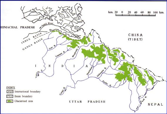
Total number of glaciers identified in Ganga basin is 968 with the glacier covered area coming to about 2,850 sq. km, which is less than 8% of the total basin area. Largest number of glaciers- totalling 407- has been identified in the Alaknanda basin that occupies 1,230 sq. km, which accounts for almost 11% of total basin area. Yamuna basin has the least number at glaciers, numbering 52, occupying 145 sq. km as the glacier covered area, which comes to just about 2% of the total basin area. Mean glaciation level varies from 5,154 masl (Alaknanda Basin) to 5,189 masl (Yamuna Basin) as shown below:
Distribution of Glaciers in Ganga Basin
|
S.NO. |
Name of Sub-basin |
Total Area (km2) |
Number of Glaciers
|
Glacier Covered Area (km2) |
Percentage of the Glacier Covered Area (%) |
Mean Glaciation Level (masl)
|
|
1. |
Bhagirathi |
7502 |
238 |
755 |
10.06 |
|
|
2. |
Alaknanda |
11132 |
407 |
1204 |
10.81 |
5154 |
|
3. |
Kaligarga/Ghagra |
8792 |
271 |
969 |
11.02 |
5169 |
|
4. |
Yammuna |
10688 |
52 |
205 |
1.91 |
2189 |
|
|
Total |
30612 |
968 |
2378 |
7.77 |
|
Glaciers in Uttarakhand
Uttarakhand cradled in the lap of Himalayas has a vivid topography. From the arduous terrains, the lush green meadows to the gigantic glaciers every little drop of nature is a sight to behold. The mighty glaciers of Uttarakhand serve as a vital source of providing fresh water to the state. These pristine glaciers are also the source of some of the important river bodies of India. The snow-clad glaciers of 'Dev Bhoomi' not only feed the perennial rivers, but they are a popular tourist attraction. The adventure enthusiasts hike on the summits of the glaciers of Uttarakhand which offer a surreal view of the enchanting land. While some of these glaciers are considered as holy and some are admired for this magnificence.
The important glaciers of Kumaon region in Uttarakhand are Kaphini Glacier, Maiktoli Glacier, Milam Glacier, Namik Glacier, Pindari Glacier, Ralam Glacier and Sunderdhunga Glacier. Bander Punch Glacier, Chorbari Bamak Glacier, Dokriani Glacier, Doonagiri Glacier, Gangotri Glacier, Khatling Glacier, Nanda Devi group of Glacier, Satopnath and Bhagirathi-Khark Glacier and Tipra Bamak Glacier are important glaciers of Garhwal region of Uttarakhand.
Bandarpunch Glaciers
|
Glacier Length |
Altitude |
Base Camp |
District |
Division |
|
12 Kms |
4442 mts |
Taluka village on Har ki Dun road |
Uttarkashi |
Garhwal |
The majestic Bandarpunch Glacier also known as Banderpoonch Glacier perched in the Garhwal division of the Himalayas is an important glacier of Yamuna basin. This glacier is about 12 km long situated on the northern slopes of Banderpoonch peak (6,316 m), Banderpoonch West (6,102 m) and Khatling Peak (6,387 m). The Banderpoonch Glacier is formed by these three cirque glaciers and later joins the Yamuna River. The Banderpoonch Glacier is highly significant as it is the prime source of fresh water for the Yamuna basin.
The snow-clad glacier of Bandarpunch offers exhilarating trekking opportunities to the adventure enthusiasts in the summer months of May and June. One can admire the scenic vista and breaths in the scent of the freshly bloomed flowers in this season.
The glacier is accessible by bus from Dehradun to Sankri-Saur and from Sankri-Saur to Talukam (11 km) by jeep, then Osia 14 km. The Osia Ruinsara Tal, nestled below the snout of the glacier is an ideal camping site.
Chorabari Glacier
|
Glacier Length |
Altitude |
Base Camp |
District |
Division |
|
7 Kms |
3800 mts |
Sonprayag |
Rudraprayag |
Garhwal |
The enormous Chorabari Glacier also known as Chorabari Bamak Glacier is situated in the Garhwal Himalayas of Uttarakhand. This glacier is close to Kedarnath shrine, which is a sacred place for Hindu pilgrims. One of the two snouts of this glacier serves as a prominent source for the mandakini River, which is tributary of Alaknanda River. The other snout at 3,835 meters about 12,582 feet above sea level drains into Chorabari Tal.
The Chorabari lies between latitudes 30°44’50”N and 30°45’30”N and longitudes 79°1’16”E and 79°5’20”E, from an altitude of approximately 6,000 metres (20,000 ft) at the slopes of Kedarnath peak to 3,800 metres (12,500 ft). The glacier has a length of 7 km, the basin area of the glacier is 38 square km and the ice cover of the glacier is about 5.9 square km. The glacier slope is 11 degrees to the south.
Chorabari Glacier is easily accessible because it is situated near to Kedarnath temple which is a very famous shrine of Hindus. Jolly Grant airport of Dehradun is the nearest airport and Rishikesh is the nearest railway station from where you can take bus o car to Sonprayag. From Sonpyrayag one can start trekking to Chorabari Glacier.
Dokriani Glacier
|
Glacier Length |
Altitude |
Base Camp |
District |
Division |
|
5 Kms |
3800 mts |
Gujjar Hut in Gangotri Region |
Uttarkashi |
Garhwal |
The Dokriani glacier also referred to as Bamak by the locals is a medium sized glacier of the Bhagirathi basin. This glacier is formed by the two cirques, originating at the northern slope of the Draupadi Ka Danda perched at 5,600 m and Jaoni Peak at 6,000 m respectively. This 5 km long glacier drains in the northwest direction, terminating at an elevation of 3,800 m.
The glacier forms a stream from its melting waters called Dingea, which joins other snow melted streams and finally merges with Bhagirathi near Bukki village. The pristine meadows and the emerald lakes situated at a distance of 2 km from the snout of the glacier serve as a good composite.
One can easily access this glacier from Uttarkashi. A 56 km road journey from Uttarkashi to Gangotri will make you reach Bukki Village. The bus terminus situated on the right bank of Bhagirathi River is about 2 km from this village. One has to cover a 23 km trek to reach Dokriani glacier.
Doonagiri Glacier
|
Glacier Length |
Altitude |
Base Camp |
District |
Division |
|
5.5 Kms |
5150 mts |
Doonagiri Village |
Chamoli |
Garhwal |
The Doonagiri Glacier is a vital glacier of Dhauli Gang system of glaciers, where more than 500 glaciers of different shapes and sizes lie in the deep and narrow valleys. This glacier is located 47 km north of Ranikhet in Almora district of Uttarakhand state.
The important glaciers are the Changbang, Girthi Hoti and Niti glaciers. Doonagiri glacier which is about 5.5 km long extends 5150 metres from its head to about 4240 metres to the snout, which is the terminal point of the glacier. A pristine stream originating from the glacier merges with Dhauliganga near the Juma village.
The Doonagiri glacier can be accessible from Juma village, which is on the way to Joshimath-Malari road, The Doonagiri village will be reached after a journey of 8 km. A 12 km trek from Doonagiri village along the Doonagiri stream goes straight to the snout of the glacier. The Bagini glacier also lies in this valley. Doonagiri village is the last village located near the Doonagiri glacier.
Gangotri Glacier
|
Glacier Length |
Altitude |
Base Camp |
District |
Division |
|
30 Kms |
3892 mts |
Gangotri in Uttarkashi |
Uttarkashi |
Garhwal |
Gangotri glacier perched in the magnificent Garhwal Himalayas is situated in the Uttarkashi district of Uttarakhand. This glacier originates at the northern slope of Chaukhamba range of peaks. This glacier serves as a vital source of Ganga river and is the largest glacier in the Himalayas, having an estimated volume of about 27 cubic km. This glacier lies between 30°43’22” - 30°55’49” latitude and 79°4’41” - 79°16’34” longitude, extending in height from 4120 to 7000 m.a.s.l. The total ice cover of Gangotri glacier is approximately 200 km and has about 20 km of ice in volume. This glacier is about 30 km long and about 2 to 4 km wide. The Gangotri glacier is surrounded by majestic peaks of Gangotri Group, offering arduous trekking to Shivling. Thalay Sagar, Maru and Bhagirathi III.
This glacier is a combination of several other glaciers that drains into it and forms a huge mass of ice. The Bhrigupanth (6772 m), Kirti stambh (6285), Sumeru Parvat (6380) respectively and, Ratavana Bamak, Charurangi Bamak ans Swachand Bamak which lies on the northeast slope of Srikailash, Man parvat, Satopanth and an un-named group of peaks.
Gangotri glacier is a popular Hindu pilgrimage site. Bathing in the icy cold water of Gangotri glacier is considered to be pious. Gomukh which means cow’s mouth is the terminus of the Gangotri ‘glacier. Gomukhs which resembles a cow’s mouth is about 19 km from the Gangotri town. It is the precise sources of the Bhagirathi River. One needs to trek from Gangotri till Gaumukh, passing Devgadh, Chirbhasa, Bhojwasa en route.
One can easily reach the Gangotri glacier as it is well connected by motorable roads up to Gangotri temple. From there a 17 km, long bridle path will take you to the right bank of the Bhagirathi River and then to Gomukh.
Kaphini Glacier
|
Glacier Length |
Altitude |
Base Camp |
District |
Division |
|
3 Kms |
3840 mts |
Khati Village of Bageshwar |
Bageshwar |
Kumaon |
The majestic Kaphini Glacier is located in the district of Bageshwar in Kumaon region of Uttarakhand state. This tranquil Kaphini glacier is situated on the left of pindar Valley, below Nandakot peak (6,860 m) and southeast of Nanda Devi peak.
This glacier is perched at an altidutde of 3,853 metres above sea level. The river Kaphini, a tributary of Pindar river emerges from this glacier. This region has an irresistible charm as it is blessed with scenic splendor, which makes it an ideal trekking destination. A wide variety of wild animals, flora and fauna can be seen in this region. One can savour the refreshing views of the snowcapped peaks, lush green meadows and flowering boulevards along the trekking trails.
Kaphini Glacier is located at a distance of 12 km from Dwali. The travelers can commence their journey to Bali Udiyar which is at a distance of 8 km from Dwali. This valley is bestowed with nature’s abundance. One can see scarlet coloured rhododendrons which bloom in the entire valley.
Khatling Glacier
|
Glacier Length |
Altitude |
Base Camp |
District |
Division |
|
3717 mts |
Ghuttu in Tehri Garhwal |
Tehri |
Garhwal |
3717 mts |
The Khatling glacier is perched at an elevation of 4,600 meters in the Garhwal Himalayas of Uttarakhand. This flank glacier is encircled by snow clad peaks of the Jogin group (6,466 m), Sphetic Pristwar (6905 m), Kirti Stambh (6902 m) and Meru. The moraines on the side of the glaciers look like standing walls of gravel mud. The best time to visit this glacier is between the summer months of April to May and September to October.
The travelers need to reach Ghuttu from where the trek to Khatling glaciers starts. One can easily reach Ghuttu by motorabloe journey from Dehradun, Tehri, Mussoorie and Rishikesh. On reaching Ghuttu, one has to trek about 45 km and pass through tiny hamlets surrounded by thick Kharsao forests and lush green meadows. The Bhilangana Valley offers pristine spots for camping.
Maiktoli Glacier
|
Glacier Length |
Altitude |
Base Camp |
District |
Division |
|
5 Kms |
Khati Villaage in Bageshwar |
Bageshwar |
Kumaon |
5 Kms |
Maiktoli Glacier is situated to the west of the Pindari glacier in the Kumaon Himalayas. This glacier is 5 km long and is situated on the southern slope of the Sunderdhunga Khal. One can also savour enchanting views of the Mrigthuni glacie situated on the western side of Mailtoli glacier. Maiktoli glacier serves as an important source of the Sunderdhunga River which forms the Sunderdhunga Khal, situated on the southern slope of the Pindari Glacier. This river later merges with the Pindar River. This glacier is bestowed with natural grandeur, the crimson rays which fall on the glacier makes the aura divine. The aesthetic beauty of this glacier makes it ideal for trekking and camping. The distance from the base camp of Song to the Maktoli Glacier is 44 km.
One can easily reach this glacier as Bageshwar is well connected with major towns of the state. Taxis are easily available from here. The nearest railhead is Kathgodam situated at a distance of 180 km. The nearest airport is Pantnagar Civil Aerodrome situated at a distance of 206 km.
Milam Glacier
|
Glacier Length |
Altitude |
Base Camp |
District |
Division |
|
16 Kms |
4242 mts |
Munsiyari |
Pithoragarh |
Kumaon |
The spectacular Milam Glacier is cradled in the Kumaon Himalayas of Uttarakhand state. It is situated in Munsiyari tehsil of Pithoragarh district, about 15 km northeast of Nanda Devi.
The Milam glacier is perched at an impressive elevation of about 5,500 meters (18,000 feet) to 3,870 meters (12,700 feet) above sea level, at its snout. The glacier sprawls over 37 km square (14 sq mi) and is 16 km (10 mi) long. Milam glacier is a vital source of the Goriganga River. It originates from the eastern slope of Trishuli and the southern slope of its eastern subsidiary Kohli.
These subsidiary glaciers emerge from the peaks of Hardeol, Mangraon (6,568 m), Deo Damla (6, 637 m) and Sakram (6,254 m) on the eastern rim of Nanda Devi Sanctuary, which flow into it from the west. While on the east, it is fed by Nanda Gond (6,315 m) and Nanda Pal (6,306 m).
Milam glacier is one of the favorite destinations of the hikers. One can approach this glacier easily as Joshimath as Munsiyari are well connected by motorable roads. The nearest railhead is at Nainital about 297 km from Johsimath and 273 km from Munsiyari. The nearest airport is Jolly Grant Airport at Dehradun about 267 km from Johsimath or Pantnagar Airport about 304 km from Munsiyari. The hikers will have to star their trek from Munsiyari for Milam glacier. The tiny hamlet of Milam lies near the snout of the glacier.
Namik Glacier
|
Glacier Length |
Altitude |
Base Camp |
District |
Division |
|
3 Kms |
3600 mts |
Munsiyari |
Pithoragarh |
Kumaon |
Namik Glacier is situated in Pithoragarh district of Uttarakhand. This glacier is perched at an altitude of 3,600 meters about 11,800 feet above sea level, in the Kumaon Himalayas. This glacier is the source of Ramganga River and is surrounded by the astounding Nanda Devi (25,748 feet), Nanda Kot (22,510 ft) and Trishuli (23,360 ft.) The Namik Glacier lies on 30°13’03’’ N 80°07’03’’ E. The length of this glacier is about 3 km.
The majestic Namik Glacier falls on the Indo-Tibet tade route. It is about 40 km from the Munsiyari tehsil. The picturesque hemlets of Gogina and Namik are in the vicinity of Namik glacier. Namik as the name symbolizes is a place where saline water springs are present. One can admire the soul refreshing views of rumbling waterfalls, creeks and sulphur springs.
This glacier is easily approachable as Uttarakhand is well connected by motorable roads. The nearest railhead is at Kathgodam and the nearest airport is Naini Saini Airport in Pithoragarh, about 128 km away. The glacier can be reached by trekking from Bala village on Thal – Munsiyari road near Birthi Fall. It is 129 km from Pithoragarh.
Nanda Devi Group of Glaciers
|
Glacier Length |
Altitude |
Base Camp |
District |
Division |
|
19 Kms |
3300 mts |
Lata Village in Chamoli |
Chamoli |
Garhwal |
The awe-inspiring Nanda Devi Group of Glaciers refers to the cluster of seven glorious glaciers namely Bartoli, Kururntoli, Nanda Devi North, Nanda Devi South, Nandakna, Ramani and Trishul in Chamoli district of Uttarakhand. Among these, Nanda Devi North and Nanda Devi South having a length of 19 km each originates from Nanda Devi peak which is 7,108 meters above sea level. These peaks are the source of the several rivers adorned in the Uttarakhand state and the whole India.
The Nanda Devi Group of Glaciers lies in the Nanda Devi Sanctuary protected as Nanda Devi National Park or Nanda Devi Biosphere Reserve. Amidst the lush green Himalayas peaks, the Nanda Devi Group of Glaciers offers serene trekking trails. One can see the lustrous beauty of the alpine meadows, the glittering peaks and pristine streams. The melted water from the gorges of Nanda Devi Group of Glaciers forms several streams and rivers. These rivers later drain Rishi Gang River which then joins Dhauliganga, one of the tributaries of Gang River. Later on, it meets Alaknanda River at Vishnuprayag.
Pindari Glacier
|
Glacier Length |
Altitude |
Base Camp |
District |
Division |
|
3 Kms |
4625 mts |
Bageshwar |
Bageshwar |
Kumaon |
The Pindari Glacier proudly sits atop the Kumaon Himalayas in Uttarakhand state. This glacier is situated to the southeast of the enchanting sister peaks, Nanda Devi and Nanda Kot. The melted ice water of the glacier flows to the south for a short distance of 3 km. The glacier is about 0.25 km in breadth and gives rise to the Pindar River, which meets Alaknanda at Karnaprayag in the Garhwal division of the Himalayas.
The 90 km trek to Pindari Glacier crosses the quaint villages of Saung, Laharkhet. Then it passes through Dhakuri Pass and continues onto Khati village, Dwali, Phurkia and zero Point (Pindar). Even though, most of the trail is along the banks of Pindar River still, the river is almost hidden until one reaches khati, which is the last inhabited village on the way to the glacier.
Ralam Glacier
|
Glacier Length |
Altitude |
Base Camp |
District |
Division |
|
2290 mts |
Munsiyar |
Pithoragarh |
Kumaon |
2290 mts |
Ralam Glacier is an enchanting Himalayan glacier idyllically situated in Munsiyari tehsil of Pithoragarh district of Uttarakhand. It lies on the foothills of the Great Himalayas, The glaciers located near Ralam Dhura at Ralam Khal in Kumaon region. Ralam glacier is perched at an altitude of 2,290 meters about 7,510 feet above sea level. This glacier is divided into two parts namely Upper Ralam and Lower Ralam. Also, there are three pristine glaciers which meet Ralam glacier namely Kalabaland, Sutela and Yangchar. The length of Ralam glacier from Munsiyari is about 15 km. The best time to trek is from the last week of April to last week of June and the first week of September to the first week of November.
Munsiyari is well connected with motorable roads, which makes it easy for the adventure enthusiasts to trek on Ralam Glacier. Munsiyari is about 612 km away from Delhi, 288 km from Delhi and about 261 km from Kathgodam. The nearest airport is Naini Saini Airport at Pithoragarh located at a distance of 128 km. The maximum altitude of this trek is 3,900 meters above sea level. One has to trek about 50 km from Munsiyari in order to reach the Ralam glacier. The hikers can rest at the tiny hamlets of Lilam, Pnaton and Sapa-Odiyar which will come on the way. From Ralam village, the hikers will have to cover a walking distance of 15 km to reach the glacier.
Satopanth Glacier and Bhagirathi-Kharak Glacier
|
Glacier Length |
Altitude |
Base Camp |
District |
Division |
|
3820 mts |
Mana village - Badrinath |
Chamoli |
Garhwal |
3820 mts |
The Satopanth and Bhagirathi Kharak glaciers are located at the head of Alaknanda Valley in Chamoli district of Uttarakhand. Both Satopanth glacier (13 m) and Bhagirath Kharak glacier (18.5 m) have an average width of 750-850 meters. These glaciers sprawl over an area of 21.17 and 31.17 square km respectively. The eastern slope of Chaukhamba group of peaks feed the ice to these glaciers. The towering peaks raging from 5,288 to 7,068 meters are snow-clad during winers. These two glaciers are separated by a linear ridge. Both the glaciers have a sinuous course as their paths are obstructed by a number of spurs. The ablation zones of both the glaciers are covered by a thick layer of debris and their snouts are located at 3858 m and 3796 m above sea level. The Alaknanda River originates from Satopanth glacier and meets Uttar Gang upstream to Alkapuri. At Mana, Alaknanda meets Saraswati River and there onwards it drains in the Badrinath basin. The enchanting Vasudhara Fall is located on the route of these glaciers.
These glaciers can be accessible from Joshimath in the Chamoli sub-division, by following the Badrinath and Mana (3,128 m) motorable road. The route follows the course of Alaknanda River from Mana village. One can savour the views of the cascading Vashudhara waterfall (145 km) which lies on the right bank of Alaknanda River at an elevation of 3,250 meters. The snout of the glaciers opens at about 5 km upwards Vasudhara. About 2 km down the valley, the left bank if the river is suitable for pitching tents. One can reach the Satopanth Glacier and Bhagirathi-Kharak Glacier in summers only.
Sunderdunga Glacier
|
Glacier Length |
Altitude |
Base Camp |
District |
Division |
|
4320 mts |
Bageshwar |
Bageshwar |
Kumaon |
4320 mts |
The magnificent Sunderdhunga glacier is erected on the beauteous Sunderdhunga Valley. The glacier is situated to the west of Pindar Valley. The Sunderdhunga glacier is perched at an altitude of 3,200 meters to 6,050 meters. It is encircled by the glorious peaks of Panwalidwar in the north, Mrigthuni (6,856 m), Maiktoli (6,804 m) and the Tharkot (6,100 m) in the west.
Sunderdhunga which means the “Valley of beautiful stones” literally lives up to its name, as the valley possesses some of the magnificent glaciers and peaks, including Maiktoli Glacier (6804 m) and Sukhram glacier.
The adventure lovers can start hiking from Saung village which is about 125 km away from Ranikhet. One can easily reach Ranikhet, which is located at a distance of 94 km from Kathgodam. The nearest railhead is at Kathgodam (219 km) and the nearest airport is Pantnagar. The hikers will have to commence a 5 km trek from Loharkhet, then another 11 km trek to Dhakuri and 14 km trek to Jailoti to Sunderdhunga one needs to trek for 21 km via Khatuli.
Tiprabamak Glacier
|
Glacier Length |
Altitude |
Base Camp |
District |
Division |
|
6 Kms |
Govind Ghat in Chamoli |
Chamoli |
Garhwal |
6 Kms |
Tiprabamak referred to as “Bamak” by the locals,is a 5 km long glacier if the Bhyundar Gang basin in the Alaknanda catchment. About 16 glaciers having different sizes and shapes drain in this basin out of which Tiprabamak and adjoining Ratanban glaciers have significance. The Tiprabamak glacier coordinates between 3043’18’’N and 7939’54’’E. The melted ice water of the Tiprabamak glacier and Ratanban glacier emerges from the single ice cave at the snout of Tiprabamak. The surface of the glacier is dominated by heavy deposits of debris. The nearby cities are Nainisain, Kandara, Khatyari, Karnaprayag and Kausani.
Tiprabamak Glacier is easily approachable from Joshimath-Badrinath road, which will take you to Govind Ghat. Upon reaching Govind Ghat, the hikers must follow an 18 km bridle path which runs via Bhiundhar village up to Ghangaria. From there a 4 km will lead you to the famous Valley of Flowers, at the foothills of the Kagbhusndi Mountain ranges. Ghangaria is the only place where the hikers can set up their camps while visiting Tiprabamak Glacier.
(Source : 1. Glacier atlas of India, Geological Society of India 2. http://www.euttaranchal.com/uttarakhand/glaciers-in-uttarakhand accessed on 03.03.2017)