Annual Precipitation
The weather in the Ganga basin is characterized by a distinct wet season
during the period of south
west monsoon (June to September). The southwest monsoon makes landfall at
the mouth of the Ganga around the first week of June and advances upstream.
By the end of July the monsoon
reaches the western end of the Ganga basin. In the majority of the basin,
the rainy season spreads
over three months (July, August and September) and usually 70 to 80% of the
total annual
rainfall occurs during this period. In the eastern part of the basin, such
as in West Bengal and Bihar, the wet season is longer, usually starting in
June and continuing until the end of September or early
October.
Sub-Basin Wise Annual Rainfall (mm) (1971 - 1987)
|
Year |
1971 |
1972 |
1973 |
1974 |
1975 |
1976 |
1977 |
1978 |
1979 |
1980 |
1981 |
1982 |
1983 |
1984 |
1985 |
1986 |
1987 |
|
Above Ramganga Confluence Sub Basin |
1451 |
915 |
1121 |
793 |
1209 |
951 |
1068 |
1442 |
809 |
1163 |
949 |
1191 |
1316 |
906 |
1084 |
992 |
618 |
|
Banas Sub Basin |
761 |
441 |
945 |
627 |
918 |
774 |
726 |
737 |
556 |
541 |
599 |
630 |
824 |
518 |
506 |
521 |
376 |
|
Bhagirathi and others (Ganga Lower) Sub Basin |
2220 |
1252 |
1856 |
1845 |
1625 |
1474 |
1879 |
1682 |
1384 |
1873 |
1705 |
1314 |
1618 |
2107 |
1655 |
1731 |
1974 |
|
Chambal Lower Sub Basin |
1135 |
654 |
792 |
753 |
1032 |
851 |
872 |
746 |
538 |
857 |
725 |
950 |
950 |
535 |
889 |
680 |
594 |
|
Chambal Upper Sub Basin |
967 |
605 |
1493 |
777 |
905 |
1133 |
906 |
969 |
768 |
738 |
848 |
794 |
891 |
898 |
707 |
943 |
635 |
|
Damodar Sub Basin |
2013 |
1206 |
1561 |
1340 |
1343 |
1183 |
1649 |
1691 |
992 |
1356 |
1345 |
1115 |
1311 |
1604 |
1288 |
1518 |
1449 |
|
Gandak and others Sub Basin |
1686 |
884 |
1401 |
1281 |
1158 |
1094 |
1232 |
1174 |
957 |
1468 |
1267 |
1010 |
1219 |
1487 |
1400 |
1447 |
1576 |
|
Ghaghara Confluence to Gomti confluence Sub Basin |
1580 |
788 |
1017 |
789 |
1057 |
993 |
1040 |
1218 |
750 |
1336 |
1019 |
947 |
921 |
1133 |
1074 |
1053 |
1135 |
|
Ghaghara Sub Basin |
1687 |
861 |
1171 |
953 |
1293 |
1011 |
961 |
1121 |
842 |
1530 |
1205 |
1229 |
1338 |
1170 |
1378 |
1138 |
949 |
|
Gomti Sub Basin |
1500 |
674 |
1020 |
774 |
1194 |
893 |
838 |
1229 |
807 |
1415 |
1024 |
1157 |
1125 |
1052 |
1124 |
905 |
750 |
|
Kali Sindh and others up to Confluence with Parbati Sub Basin |
1209 |
697 |
1293 |
887 |
1083 |
985 |
959 |
936 |
681 |
821 |
823 |
963 |
971 |
814 |
951 |
1027 |
802 |
|
Ramganga Sub Basin |
1494 |
877 |
1241 |
784 |
1210 |
1016 |
1057 |
1323 |
748 |
1239 |
959 |
1128 |
1440 |
975 |
1234 |
994 |
592 |
|
Sone Sub Basin |
1609 |
1116 |
1166 |
878 |
1225 |
1128 |
1338 |
1465 |
774 |
1336 |
1054 |
1091 |
1128 |
1260 |
1167 |
1171 |
1284 |
|
Tons Sub Basin |
1435 |
953 |
1058 |
743 |
1241 |
996 |
1213 |
1449 |
719 |
1408 |
962 |
1062 |
1057 |
1120 |
1028 |
1040 |
1035 |
|
Upstream of Gomti confluece to Muzaffarnagar Sub Basin |
1231 |
720 |
919 |
685 |
1013 |
824 |
1003 |
1196 |
664 |
1156 |
856 |
934 |
982 |
872 |
909 |
831 |
624 |
|
Yamuna Lower Sub Basin |
1240 |
801 |
983 |
820 |
1110 |
885 |
1063 |
1107 |
608 |
1233 |
805 |
1150 |
1177 |
825 |
1096 |
889 |
817 |
|
Yamuna Middle Sub Basin |
755 |
600 |
636 |
590 |
826 |
746 |
925 |
707 |
389 |
679 |
635 |
680 |
913 |
529 |
685 |
487 |
323 |
|
Yamuna Upper Sub Basin |
1194 |
742 |
896 |
727 |
1055 |
885 |
931 |
1218 |
671 |
760 |
728 |
943 |
1011 |
711 |
825 |
752 |
545 |
|
Kosi Sub Basin |
1820 |
762 |
1483 |
1575 |
1234 |
1348 |
1242 |
1176 |
1128 |
1449 |
1409 |
793 |
1243 |
1667 |
1598 |
1491 |
1990 |
|
Sub-Basin Wise Annual Rainfall (mm) (1988 - 2004) |
|
|
Year |
1988 |
1989 |
1990 |
1991 |
1992 |
1993 |
1994 |
1995 |
1996 |
1997 |
1998 |
1999 |
2000 |
2001 |
2002 |
2003 |
2004 |
|
Above Ramganga Confluence Sub Basin |
1203 |
946 |
1282 |
767 |
884 |
1142 |
974 |
1073 |
1080 |
1130 |
1354 |
914 |
1267 |
906 |
918 |
1196 |
979 |
|
Banas Sub Basin |
543 |
492 |
729 |
561 |
653 |
537 |
732 |
702 |
774 |
821 |
627 |
556 |
415 |
507 |
300 |
580 |
575 |
|
Bhagirathi and others (Ganga Lower) Sub Basin |
1805 |
1814 |
1892 |
1915 |
1471 |
1895 |
1427 |
2252 |
1705 |
1875 |
2276 |
2404 |
1924 |
1842 |
1768 |
1814 |
1749 |
|
Chambal Lower Sub Basin |
725 |
483 |
835 |
680 |
813 |
750 |
805 |
877 |
845 |
853 |
751 |
866 |
635 |
753 |
415 |
725 |
618 |
|
Chambal Upper Sub Basin |
837 |
641 |
1061 |
754 |
689 |
859 |
1120 |
753 |
1051 |
973 |
830 |
801 |
496 |
664 |
528 |
829 |
873 |
|
Damodar Sub Basin |
1398 |
1351 |
1627 |
1490 |
1254 |
1460 |
1496 |
1713 |
1435 |
1686 |
1514 |
1924 |
1406 |
1538 |
1437 |
1461 |
1340 |
|
Gandak and others Sub Basin |
1337 |
1342 |
1235 |
1112 |
913 |
1189 |
1182 |
1187 |
1285 |
1353 |
1421 |
1500 |
1251 |
1303 |
1122 |
1255 |
1058 |
|
Ghaghara Confluence to Gomti confluence Sub Basin |
971 |
1039 |
1233 |
962 |
792 |
891 |
1088 |
951 |
1024 |
1145 |
1077 |
1184 |
965 |
1101 |
842 |
1103 |
573 |
|
Ghaghara Sub Basin |
1118 |
1102 |
1287 |
916 |
840 |
1175 |
935 |
994 |
1076 |
1121 |
1308 |
1001 |
1276 |
1022 |
901 |
1166 |
860 |
|
Gomti Sub Basin |
866 |
781 |
1026 |
882 |
834 |
793 |
770 |
835 |
971 |
988 |
1030 |
968 |
962 |
877 |
736 |
1089 |
680 |
|
Kali Sindh and others up to Confluence with Parbati Sub Basin |
832 |
621 |
1103 |
779 |
765 |
979 |
1104 |
905 |
1039 |
1008 |
831 |
1008 |
632 |
796 |
578 |
872 |
821 |
|
Ramganga Sub Basin |
1098 |
906 |
1345 |
781 |
872 |
1248 |
855 |
1092 |
1019 |
1081 |
1362 |
950 |
1339 |
853 |
1009 |
1381 |
904 |
|
Sone Sub Basin |
997 |
978 |
1307 |
1018 |
907 |
1045 |
1462 |
1036 |
1091 |
1353 |
1187 |
1238 |
971 |
1312 |
986 |
1374 |
1009 |
|
Tons Sub Basin |
961 |
843 |
1251 |
980 |
952 |
898 |
1228 |
954 |
949 |
1187 |
1011 |
1318 |
1033 |
1123 |
869 |
1261 |
821 |
|
Upstream of Gomti confluece to Muzaffarnagar Sub Basin |
887 |
623 |
922 |
753 |
773 |
717 |
819 |
802 |
904 |
925 |
985 |
961 |
839 |
774 |
701 |
1023 |
568 |
|
Yamuna Lower Sub Basin |
908 |
670 |
1155 |
812 |
927 |
936 |
1032 |
865 |
994 |
1015 |
939 |
1138 |
811 |
925 |
749 |
1105 |
771 |
|
Yamuna Middle Sub Basin |
751 |
424 |
694 |
512 |
705 |
644 |
631 |
817 |
812 |
736 |
800 |
654 |
516 |
513 |
430 |
780 |
469 |
|
Yamuna Upper Sub Basin |
1054 |
763 |
1020 |
642 |
753 |
800 |
919 |
966 |
1047 |
1008 |
1052 |
686 |
839 |
761 |
574 |
778 |
819 |
|
Kosi Sub Basin |
1414 |
1594 |
1228 |
1193 |
956 |
1450 |
931 |
1250 |
1261 |
1401 |
1570 |
1723 |
1380 |
1296 |
1092 |
1279 |
1096 |
The average annual rainfall for Ganga basin varies from 400 - 2000 mm.
The value of rainfall for 34 years (1971-2005) the Ganga basin can be
broadly is classified into 11
zones based on the rainfall received in that area. About 27.31% of total
area of Ganga basin
receives a rainfall of 1000-1200mm, 23.14% area receives 800-1000mm, 15.51%
area of the basin receives 600-800mm and 14.29% of basin area receives
1200-1400mm. The trend of monthly average from 1971 to 2004 is given below :
Trend
of monthly average rainfall (1971-2004)
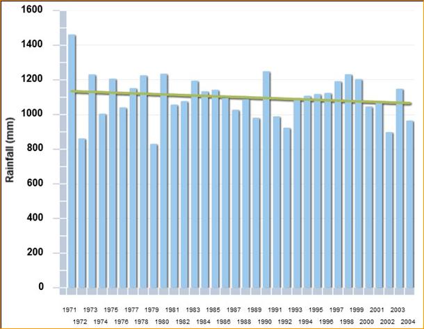
The annual average rainfall in the basin varies between 400 - 2000 mm. 80%
of the rainfall occurs during the monsoon months i.e. between June and
October. Because of large temporal
variations in precipitation over the year, there is wide fluctuation in the
flow characteristics of the river. The highest rainfall of 1441.26 mm
is observed in 1971 and lowest rainfall of 786.57 mm is observed in 1979.
The trend line of monthly average rainfall (1971-2004) shows that there is a
marginal decrease in average annual rainfall. The average annual rainfall
for the basin is estimated as 1059.74 mm.
Within the Ganga basin, every square kilometer of land surface area receives
an average of 1 MCM
of water annually through rainfall. However, less than half of this is
actually available, after
accounting for water lost through evapo-transpiration (30%) and seepage into
the ground (20%).
Since the vast majority is concentrated in a three month span in most of the
basin, the water
available from rainfall usually exceeds what is lost through evaporation
during this period, allowing
some surplus water to flow down the Ganga and its tributaries.
Ministry
of Rural Development (MoRD), in 2002, has identified the districts and
blocks that are affected by drought and declared them as drought prone under
Drought Prone Area Programme (DPAP). As per DPAP scheme, the Ganga basin has
76 districts of 9 states are affected by drought (Bihar - 6 districts,
Chhattisgarh - 3 districts, Himachal Pradesh - 1 districts, Jharkhand - 14
districts, Madhya Pradesh - 16 districts, Rajasthan - 8 districts,
Uttarakhand - 7 districts, Uttar Pradesh - 16 districts, West Bengal - 5
districts).
(1. Source: India-WRIS
2. NGBRA report on Environmental and Social Management Framework)