|
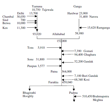
Hydrology with River Line Diagram of Ganga & it's tributaries
The headwater reaches of the river receive a considerable part of precipitation as snow and some mountain peaks in the region are permanently snow covered. The average annual rainfall in the basin varies from 35 cm at the western end to nearly 200 cm near the delta. The average annual discharge of the Ganga rivers is 16,650 m 3/s, respectively. The average annual flow of Ganga at Farraka is about 525×105Mm3. There are large variations in the flow of Ganga with time. Snow and glacier melt during the hot months (March to June) and provide large summer flows to Ganga and its tributaries. The maximum discharge in these rivers is observed during monsoon months (June to September). At Goalundo, the average annual flow of the Ganga River is 11,470m3/s. The maximum and minimum flow at this site is 70,934 and 1,161m3/s. The peak flow at Farakka in 1971 was estimated at 70,500m3/s.
A line diagram of Ganga and its main tributaries showing average annual flows at various gauging points/ tributaries in million cubic metres is given below:
There are several features which immediately attract attention. The south bank tributaries (left side of figure) contribute less than the northern tributaries; the discharge at Delhi, far upstream of Yamuna, is relatively quite small; the total flow of the Brahmaputra is greater than that of the Ganga; and significantly, no figure is given for discharge down the River Bhagirathi. What the simple figure does not show is: the huge fluctuation between monsoon flows and the low season, when many of the south bank rivers simply dry up, and the north bank rivers have a vastly reduced flow; the fluctuation from year to year; and current and projected storage dams and their capabilities, which could smooth out the irregularities on an annual or inter-annual basis.
The surface water resource potential of the Ganga and its tributaries in India has been assessed at 525 billion m 3 out of which 250 billion m3 is considered to be utilizable. Based on the 1991 census, the per capita water availability in the basin was nearly 1,471m3 per year. Although the Ganga basin is bestowed with abundant water resource, its occurrence/availability both in quantity and quality is not uniformly distributed either spatially or temporally. More than 75% of the annual rainfall occurs in monsoon months of June to September.As a result, large areas are subjected to floods on one hand and droughts on the other.
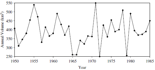
The storage potential of the Ganga Basin in India has been identified at 8446×104Mm3. However, till 1995 a total of 368×104Mm3 of the storage space could be created. Water resources development schemes to create storage of 1706×104Mm3 are under construction and projects to provide another 2956×104Mm3 of storage are in the pipeline. The total replenishable ground water resource of the Ganga basin is estimated at 171×105Mm3 out of which, about 486×104Mm3 was being utilized by 1999. The Ganga River carries one of the world’s highest sediment loads, equal to nearly 1,451 million metric tons per annum. During the lean season, the discharge in Ganga at Narora could be as low as 321 cumec. Further down at Kannauj, it is 1,542 cumec and at Kanpur 1,679 cumec. At Allahabad, where Yamuna meets Ganga, lean season flow has been recorded as 1,870 cumec; at Varanasi it is 4,120 cumec, at Patna it is 5,693 cumec, and at Mungher the lean season flow is about 7,250 cumec. The annual discharge of Ganga at Farakka for the period 1950 to 1985 is shown below:
Except in the Uttarakhand and Uttar Pradesh Himalayas, PE exceeds precipitation and water deficit conditions prevail in the entire Ganga basin. Only during the monsoon season, especially during the early rainy season, rainfall first recharges soil moisture, which was used up previously and then, raises the groundwater level. Surface and sub-surface runoff is produced when soil becomes saturated. Ballia, Pipri in eastern UP and districts in western part of the state like Agra, Aligarh, Meerut, Mainpuri, Kanpur and Bareilly do not show any water surplus. In the foothills of Himalayas in the Tarai areas, water surplus occurs during the monsoon period. The Ganga and its tributaries have formed a large flat and fertile plain in North India. The availabilities of abundant water resources, fertile soil, and suitable climate have given rise to a highly developed agriculture based civilization and one of the most densely populated regions of the world. The net sown area in the Ganga basin in India is around 44 million hectares (M-ha) and the net irrigated area is 23.41 M-ha. Migration of the tributaries draining the eastern part of the basin has resulted in conspicuous back-swamp and meander bolt deposits. These sedimentological features play a dominant role in the hydrodynamics of the region. The length and origin of major rivers and tributaries are: Length of major rivers
(Source: India-WRIS) |