|
Topography
The
catchment area of the Ganga
falls in four countries, namely India,
Nepal, Tibet (China),
and Bangladesh.
The major part of the geographical area of the Ganga
basin lies in India which comprises of three large topographic
divisions of Indian subcontinent, namely the Himalayan
Young Fold
Mountains, the Gangetic Plain, and the Central Indian highlands. The Himalayan Fold
Mountains comprises the Himalayan ranges
including their foot hills with numerous snow peaks rising above 7000m. Each of these peaks is
surrounded by snow fields and glaciers. All the tributaries are characterized by well regulated flows and assured
supply of water throughout the year by
these glaciers. The Gangetic plains, in which the
main stem of Ganga lies, situated between the Himalayas and the Deccan plateau, constitute the most of the
sub-basin ideally suited for intensive
cultivation. It consists of alluvial formation and is a vast flat
depositional surface at an elevation
below 300m. The Central highlands lying to the south of the Great
Plains consists of mountains,
hills and plateaus intersected by valleys and river plains. They are largely
covered by forests. Aravali uplands, Bundelkhand
upland, Malwa plateau, Vindhyan
ranges and Narmada
valley lies in this region.
The Gangetic
plains are mostly divided into three parts, Upper Ganga
plains, Middle Ganga plains and Lower Ganga plains. The Upper Ganga
plain is the part of the Great Plains lying
approximately between the Yamuna in the west covering the parts of Uttarakhand and Uttar Pradesh. The region is delimited in the north by 300m contour which
separates it from the Garh - Kum
Himalaya west of Sarda while theInternational
boundary of Nepal
marks the limit towards the east. In the south the
Yamuna demarcates its border with the Bundelkhand. The axis of the topographic trough paradoxically lies nearer the peninsular block or
along the Ganga
which traverses the area in a south-southeasterly direction. Thus
there is, though not perceptible, a tract adjacent to the foot hills where the slope is higher and has resulted in the
preponderance of numerous small streams, assigning a somewhat medium to fine texture to this part. The southern
counterparts, particularly north of the Ganga are
characterized by the sluggishly-flowing streams like the Ramganga
and the Ghaghara studded with ox-bows, sandy stretches (the Bhurs) etc. The topographic diversities produced by the changing river courses are
predominantly observed in the Ramganga and the Ghaghara valleys,
particularly in their flood plains.
The streams such as the Kali, the Hindan, and the Pandu etc. have
to go a long way parallel to their master streams to empty themselves. Distinct, though areally insignificant, in topographic expressions is the Yamunapar or the Yamuna-lower Chambal tract. The deep valley separated by sharp spurs and buttresses are the
main features of Upper Ganga Plain. Topographically
most significant and complex part of the
region is the submontane belt, running at the foot
of the Shiwaliks from
west to east across the area on the northern border consisting of the two
parallel strips - the piedmont zone, the Bhabar
(the Doab region) and the adjoining relatively
gently sloping Tarai belt.
The Middle Ganga
Plain is the largest among the three plains of the Ganga. It covers the Bihar plains and the Eastern Uttar Pradesh lying
on the entire side of the Ganga and the Ghaghara within the Himalayan
and the peninsular ramparts on the north and the south respectively. Structurally
the region is the
segment of the great Indo-Ganga trough; however it
has some marginal portions of the other two major formations that are Siwaliks in the northern part of the Champaran
district and the fringes and the projections of the peninsular block in the south. In
general, it is below 100m above the sea level, except that is gradually rises from Domariaganj in Basti up to 130m
in the North West
and up to 150m in the south in cooperating the projections of the southern
uplands; in the east the Kosi plain ranges between
30m in the south to 75m in the extreme north. A more pronounced relief is
occasioned when the plain meets the hilly area in the north bearing the stamp
of their loosely-set gravelly nature, particularly in the extreme north,
where the surface appears to be broken by large rivers like the Ghaghara,
the Rapti, the Gandak,
the Bagmati, the Kosi
etc., which comb the region with their
affluents in an intricate pattern.
The Lower Ganga
Plain includes the Kishanganj district of Bihar,
whole of West Bengal excluding the Purulia
district and the mountainous parts of Darjeeling
district and most of the parts of Bangladesh. The region embraces the area from the foot of
the Darjeeling Himalayas in the north to the Bay of Bengal in the south and
from the edge of the Chottanagpur
Highlands in the west to the border
of Bangladesh and Assam in the east. Topographic
expressions in the region hardly speak of any well-defined stage of their evolution. The monotonous
surface is dissected frequently by the channels of the tributaries or
distributaries of the main stream, the Ganga. There are:
·
The Malda west Dinajpur tract where the inliers of the lateritic alluvium are sufficient to break the general
monotony of the plain,
·
The tract bordering the Chottanagpur
Highlands,
·
The Midnapore
Coast where the sand dunes on the terraces appear to be
more significant element of landforms,
·
The Duars of Jalpaigurl and Darjeeling. To the east of the shoreline
lies bulge of the Ganga
(Sundarbans) where the depositional activity of the stream is prominent and new
surface is being continuously added.
Many
important tributaries of Ganga originate in the
Himalayas in India and Nepal; Bangladesh lies in the deltaic
region of the basin. The total length of the Ganga River
is 2,525 km which makes it the 20th longest river in Asia
and the 41st longest in the world (Philips World Atlas). The navigable length
of Ganga River is 631 km which mostly lies in Bihar. An index map of the basin is given here.
Although
the headwaters region of Ganga in the Himalayas is
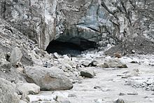
dotted by a number of mighty tributaries, the Bhagirathi River
that rises from the Gangotri glacier near Gomukh at an elevation of about 7,010m above mean sea
level is traditionally considered to be the source of Ganga River.
The other main stream that originates in the Uttarakhandl
state of India
is the Alakhnanda. Flowing downhill, Bhagirathi and Alakhnanda are
joined by a number of streams, such as the Mandakini,
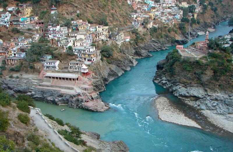
the Dhuli Ganga, and the Pindar. These two rivers (Bhagirathi
and Alakhnanda) meet at a place called Devprayag and thereafter the combined flow is known by
the name Ganga.
Ganga enters into
plains near Haridwar and from here it flows in
south/southeasterly direction. Yamuna is the most
important tributary of the Ganga that joins it on
the right bank at Allahabad.
After confluence with Yamuna, the Ganga River flows in an eastward direction and is joined
by a number of tributaries, such as the Ramganga, the
Gomti, the Ghaghra, the Gandak, the Bagmati, the Kosi, the Sone and the Damodar.
The
delta of Ganga is
said to begin at a place known as Farakka where a
barrage has been constructed to control river flow. At about 40 km downstream
of Farakka, the river splits in two arms. The right
arm, the Bhagirathi
River, flows towards south and
enters the Bay of Bengal about 150 km downstream of Calcutta. The left arm, known as Padma, turns towards east and enters Bangladesh. While flowing in Bangladesh, Padma
meets the Brahmaputra
River at a place known
as Goalundo. The combined flow, still known as Padma, is joined by another mighty river, Meghna, at Chandpur, 105 km
downstream of Goalundo. Further down, the river
ultimately flows into the Bay of Bengal.
The
Ganga basin
extends over an area of 1,086,000km2. It lies between east
longitudes 73° 30' to
89° 0' and
north latitudes 22° 30' to
31° 30'. The drainage area lying in India is 862,769km2
which is nearly 26.2% of the total geographical area of the country. Some
tributaries, such as the Ghagra, the Gandak and the Kosi, drain
areas in Nepal
amounting to 190,000km2. The delta of the Greater Ganga basin covers an area of 56,700km2. The Ganga basin is bounded on the north by the Himalayas, on
the west by the Aravalis and the ridge separating
it from the Indus basin, on the south by the Vindhyas
and Chhotanagpur plateaus and on the east by the Brahmaputra ridge. The basin
lies in the States of Uttarakhand, Uttar Pradesh,
Madhya Pradesh, Bihar, Rajasthan, West Bengal,
Haryana, Himachal Pradesh
and the Union Territory of Delhi. The State-wise distribution of the drainage
area is given in Himalayas, on the west by the Aravalis
and the ridge separating it from the Indus basin, on the south by the Vindhyas and Chhotanagpur
plateaus and on the east by the Brahmaputra
ridge. The basin lies in the States of Uttaranchal,
Uttar Pradesh, Madhya Pradesh, Bihar, Rajasthan, West
Bengal, Haryana, Himachal
Pradesh and the Union Territory of Delhi. The State-wise distribution of the
drainage area is given in below:
State-wise distribution of the drainage area
of Ganga River in India
|
State
|
Drainage area (km2)
|
|
Uttarakhand
and Uttar Pradesh
|
294,410
|
|
Madhya Pradesh
|
199,385
|
|
Bihar
|
143,803
|
|
Rajasthan
|
112,490
|
|
West
Bengal
|
72,618
|
|
Haryana
|
34,271
|
|
Himachal
Pradesh
|
4,312
|
|
U.T. of Delhi
|
1,480
|
|
Total
|
862,769
|
From
a hydrological studies point of view, the entire run of Ganga River
in India
can be divided in three stretches or reaches. The upper reach extends from
the origin to Narora, the middle reach from Narora to Ballia, and the lower
reach from Ballia to its delta. The main physical
sub-divisions of the Ganga basin are the Northern Mountains,
the Gangetic Plains and the Central Highlands.
Northern Mountains comprise the Himalayan
ranges including their foothills. The Gangetic
plains, situated between the Himalayas and the Deccan plateau, constitute the most fertile
plains of the basin that are ideally suited for intensive cultivation. The
central highlands lying to the south of the Great Plains
consists of mountains, hills and plateaus intersected by valleys and river
plains. They are largely covered by forests. Aravalli
uplands, Bundelkhand upland, Malwa
plateau, Vindhyan ranges and Narmada valley lie in this region.
The terrain of the basin is very rugged in the north-eastern
part and flat towards downstream side. The
Himalayan region of the basin contains nine of the fourteen highest peaks in the
world over 8,000m in height, including Mount Everest
which is the highest point of the basin. The
other peaks over 8,000m in the basin are Kangchenjunga,
Lhotse, Makalu, Cho Oyu, Dhaulagiri,
Manaslu, Annapurna and Shishapangma.
The Himalayan portion of the basin includes the southeastern portion of the state of Himachal
Pradesh, the entire state of Uttarakhand and the
extreme north-western portion of the state of West
Bengal. Major area of the basin falls within 300-500 m elevation
zone. The elevation variation the basin is given below :
Elevation
zones
|
Sl. no.
|
Elevation (m)
|
Area (Sq.km.)
|
% of Total Area
|
|
1
|
< 5
|
10441.16
|
1.21
|
|
2
|
5-10
|
8320.58
|
0.97
|
|
3
|
10-50
|
58940.57
|
6.84
|
|
4
|
50-100
|
122902.46
|
14.27
|
|
5
|
100-200
|
200790.42
|
23.31
|
|
6
|
200-300
|
123124.65
|
14.29
|
|
7
|
300-400
|
105002.90
|
12.19
|
|
8
|
400-500
|
114920.62
|
13.34
|
|
9
|
500-750
|
59722.04
|
6.93
|
|
10
|
750-1000
|
8741.36
|
1.01
|
|
11
|
1000-1500
|
11636.73
|
1.35
|
|
12
|
1500-2000
|
10699.95
|
1.24
|
|
13
|
2000-3000
|
9540.63
|
1.11
|
|
14
|
3000-4000
|
4886.73
|
0.57
|
|
15
|
4000-5000
|
6320.05
|
0.73
|
|
16
|
5000-6000
|
5096.32
|
0.59
|
|
17
|
> 6000
|
364.8297
|
0.042351
|
(Source: India_WRIS)
|