Ajay River
Ajay River is a major river in Jharkhand and West Bengal. It
originates in the low hills near Deoghar in the Santhal Pargana District of Jhakhand and flows in a south-easterly direction passing through the Monghyr District and Birbhum and Burdwan Districts of West Bengal. Ultimately the river falls into the Bhagirathi River at Katwa about 216 km above Calcutta. The Ajay River system lies between the Mayurakshi on the north and Damodar and the Banka/Khari River system on the south. The catchment of the Ajay River spreads between latitudes 23°25' N and 24°35' N and longitudes 86°15' E and 88°15' E.

(Source: https://www.google.co.in/maps access on 08.06.2016)
The habitation in the catchment on the whole is dense and requires a reliable flood warning system which can provide timely warning to the people with sufficient lead time to take precautionary measures which can save lives and their valuables.
The Ajay River traverses a total length of 299 km, 24 km being in Monghyr, 102 km in District Santhal Pargana, 22 km along the boundary of Santhal Pargana and Burdwan, 115 km along the boundary between Singhbhum and Burdwan and the rest of the total length falls in the Burdwan district of West Bengal. It meets the Bhagirathi near Katwa. The river has a catchment area of 6,050 sq. km. The various tributaries of the Ajay River are Darua, Pathro, Jainti, Hinglo, Tumuni, Kane, Kanur and Kundur.
The catchment area of the Ajay River is long and narrow. The river course has remained more or less firm and there is no evidence of marked changes in the course. The bed slope of the river in different reaches varies considerably. The slope of the main river is flatter than that of the tributaries and slope in the plains of West Bengal is much flatter than that in its upper reaches. The Ajay catchment lies in the path of tropical depressions or cyclonic storms which form in the Bay of Bengal in the monsoon period and move generally in the north-west direction. Abnormally heavy rain spells are generally associated with these storms during monsoon. The average annual rainfall in the river catchment varies from 1,280mm to 1,380 mm; higher values being associated with hills. Nearly 75% to 80% of the rainfall is concentrated in the four monsoon months of June to September.
The important tributaries of the Ajay are Pathro and Jayanti in Jharkhand, and Tumuni and Kunur in Bardhaman district of West Bengal.
The river system is divided into three reaches from the point of view of floods. The upper reach is almost hilly, having comparatively steep slope. The middle reach is subjected to occasional flooding caused due to breaches and overtopping of the embankment during high floods in the river. Whenever the river is in high stage, flood locking of its tributaries takes place, which causes heavy spill on both sides of the rivers. Even during moderately high discharge the lower reach is the worst flood prone reach of the river and it suffers from very frequent inundation.
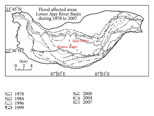
There has been at least 14 recorded floods in the 20th century in the Ajay river. The lower reaches of the river have embankments to prevent flooding. Flood affected areas of Lower Ajay River Basin during 1978 to 2007 is given below:
(Source : http://www.hindawi.com/journals/geography/2013/214140.fig.003a.jpg access on 08.06.2016)