Damodar River
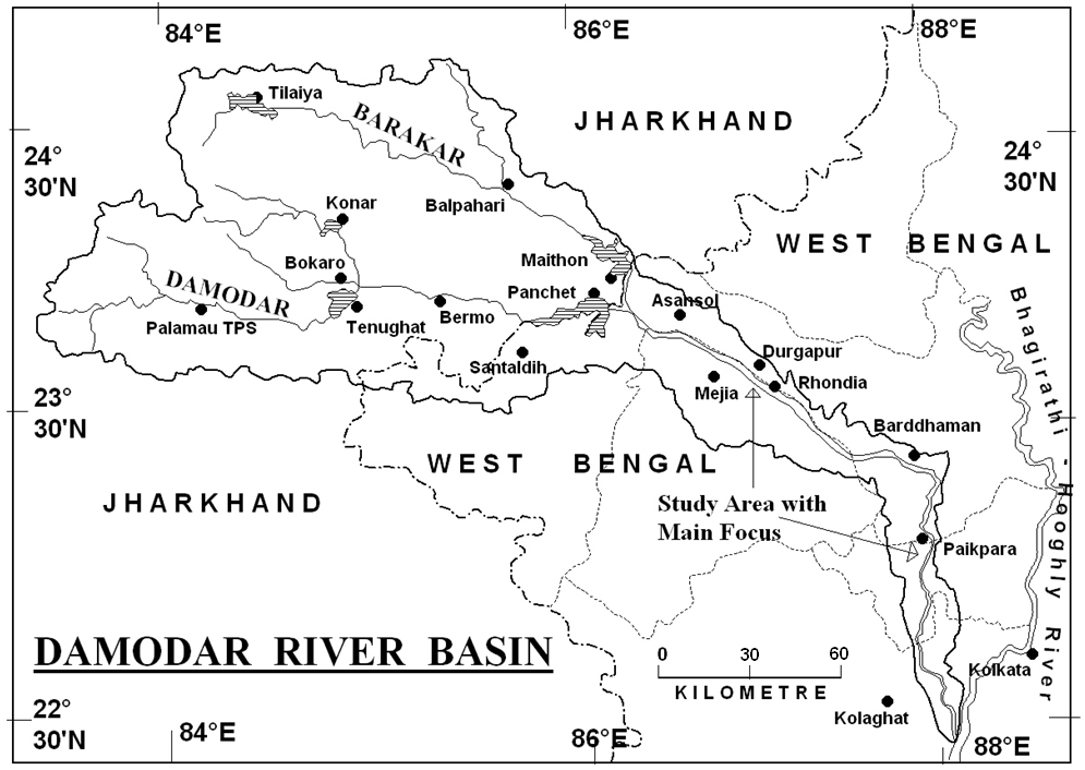
The Damodar River rises in the Palamau hills of Choota Nagpur at an elevation of about 609.75 m. It flows in a south-easterly direction entering the deltaic plains below Raniganj. Near Burdwan, the river abruptly changes its course to a southerly direction and joins Hooghly about 48.27 km below Calcutta. Its slope during the first 241.35 km is about 1.89 m/km, during the next 160.9 km about 0.568 m/km and during the last 144.8 km about 0.189 m/km. The total length of the river is nearly 547 km and a total drainage area is 22,005 sq. km. The principal tributary Barkar joins the Damodar after traveling for about 241 km. The catchment area of the river above the confluence is fan shaped and as such is susceptible to the concentration of flood flows but the catchment below the confluence is narrow and has an average width of 16.09 km. The upper catchment is rough hilly areas denuded of forest and vegetal cover and is subject to erosion while the lower catchment is silt covered and fertile. There are no irrigation facilities in the upper catchment and the cultivation is solely dependent on monsoon rains. However the lower portion had irrigation from the Anderson Weir situated at Rhondia on the Damodar nearly 19 km below the Durgapur Barrage.
(source : http://www.cibtech.org/J-GEOLOGY-EARTHENVIRONMENT/PUBLICATIONS/2013/Vol_3_No_2/JGEE...11-017%E2%80%A6%20SANDIPAN%E2%80%A6%20ESTIMATION%E2%80%A6%20INDIA.pdf accessed on 10.06.2016)
Damodar basin lies in the states of Jharkhand and West Bengal. Based on the 2001 census, the population of the basin is close to 14.25 million. For this population, domestic demand has been estimated at 338.46 MCM/year. This demand is likely to increase to 507 MCM/year by the year 2021 (Roy et al. 2004). For the industrial sector, the present water demand is 663 MCM/year which is about 15.36% of the utilizable water potential of the basin. This demand is likely to increase to about 884 MCM/year by the year 2021 due to new thermal power plants, brick fields, rice mills, and cold storages etc.
Two irrigation canals, the Left Bank Main Canal and the Right Bank Main Canal take off from the Durgapur barrage. The cultivable command area in the basin is 3,940 sq. km. Water demand for agricultural uses in the Damodar basin for the year 2001 was nearly 652.41 MCM/year. This demand is projected to sharply rise to 1,948 MCM/year by the year 2021. At present, the infrastructure for irrigation is highly inadequate in the basin.
Tributaries of Damodar
The tributaries and subtributaries of the Damodar include Konar, Barakar, Haharo, Bokaro, Ghari, Jamunia, Khadia, Guaia and Bhera. The biggest tributary of the Damodar River is the Barakar. The source of Barakar is located in the vicinity of Padma in Hazaribagh district. Subsequently, the river runs through Jharkhand prior to joining the Damodar close to Dishergarh in West Bengal. The Barakar and the Damodar get the Chota Nagpur flat terrain divided into three parts. The rivers flow through mountainous regions with enormous might, overwhelming anything that comes in their way.
Climate
The climate of the area consists of very mild winters and hot-wet summers. During the months of December to March the general flow of surface air is northeasterly. It is of continental origin and is less humid. During June to September, the flow of wind is southwesterly, from sea to land, and this period has high humidity. Transition seasons of the hot weather months of April and May and the retreating monsoon months of October and November lie between the above two principal seasons. In general the months of June to October are known as monsoon season and nearly 90% of the mean annual rainfall of about 1,250 mm occurs in this period. The months of November to May are known as non-monsoon or dry period when rainfall is small. For the five sub-catchments, namely, Tilaiya, Konar, Maithon, Panchet, and Durgapur, the average annual precipitation is 1,117.7 mm, 1,320.8 mm, 1,141.7 mm, 1,142.0 mm, and 1,320.8 mm respectively.
Heavy rainfall occurs generally in the Damodar Valley due to:
-
The monsoon depression from head bay moving in a north west direction over the catchment or west-north-west direction passing near the catchment area., and
-
The land low developing over Gangetic West Bengal or Bihar Plateau and the remaining stationary or moving slowly across or near the Damodar Valley.
The average yearly precipitation on the Chota
Nagpur terrain is approximately 1400 mm, and nearly the whole amount of it
takes place in the monsoon season, between June and August. The enormous
quantity of water that runs through the Damodar River and its tributaries at
the time of the monsoons was mighty and the flow was quite vehement in the
higher basins of the plateau. However, in the lower basins, the river
flooded its banks and inundated other big localities nearby.
In the past, the Damodar River used to cause frequent and immense flood damages in Bihar and West Bengal, so much so that the river came to be associated with sorrow and sufferings. To overcome these, the then government decided to build a series of dams on the pattern of developments in the Tennessee Valley in the USA. Accordingly, five dams were constructed in the Damodar Valley, namely, Maithon, Panchet, Konar, Tilaiya and Tenughat and a barrage was constructed at Durgapur. Further, the Damodar Valley Corporation (DVC) was established in 1948 for management of the Damodar Valley water resources. The dams in the Damodar system serve for different purposes, viz., domestic and industrial water supply, flood control, irrigation, and hydropower generation.
Present Scenario
At present, the Damodar is the most contaminated river in India, due to the various industries that have mushroomed on its riverbanks, which are good resources of minerals. There are a number of coal-oriented industries that are scattered over the Damodar basin. Majority of them are government-owned coke oven plants; coal washeries, important iron and steel plants in India; glass, zinc, and cement plants; and thermal power plants. The contamination was a result of excessive excavation, oil, fly ash, poisonous metals, as well as coal dust.
(Source:
http://www.mapsofindia.com/maps/rivers/damodar.html and
http://www.indianetzone.com/33/origin_damodar_river_indian_river.htm
accessed on 09.06.2016)