Gandak River
Gandak River is a tributary of the Ganga
or Ganges River. It is one of the major rivers in Nepal and India. It is also known as the Kali Gandaki and Narayani after the
confluence with Trisuli in Nepal. It is a
north bank tributary of the Ganga in India. It rises at 7620 m in Tibet near
the Nepal border and overlooks the Dhualagiri peak. It is distinguished for
the deep gorge across which it flows and for a large hydroelectric facility
in Nepal. This river also provides water for a major Irrigation cum
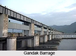
Hydroelectric power facility at the Indo-Nepal border at Valmikinagar. The
river has a total catchment area of 46,300 sqkm out of which 7620 sq km is
located in India. The Gandaki River is mentioned in the ancient Sanskrit
epic Mahabharata.
The Kali Gandaki starts at the north of Tibetan plateau of the Himalayas in
the Mustang District of Nepal, near the Tibetan border. The two headwaters
of river, Nup Chhu and Shar Chhu meet near the town of Lo Manthang in upper
Mustang. These two rivers are also called the "West River" and "East River.
These rivers then flow southwest with the name of Mustang Khola. In Kagbeni
a major tributary, Kak Khola, flowing from Muktinath, meets Mustang Khola,
and since then together this river is called the Kali Gandaki.
The course of this river advents southwards through a steep gorge known as
the Kali Gandaki Gorge, or Andha Galchi, between the mountains Dhaulagiri
(rising up to 8167 m) to the west and Annapurna (8091 m) to the east side.
If one measures the depth of a canyon by the difference between the river
height and the heights of the highest peaks on either side, the Gorge is the
world's deepest. The course of the river between the Dhaulagiri and
Annapurna massifs is at a height of between 1300 metres and 2600 metres. The
river is much more older than the Himalayas.
The river is joined by Rahught Khola at Galeshwor at the south of the gorge,
Myagdi Khola at Beni, Modi Khola near Kushma and Badigaad at Rudrabeni. The
river then takes a right-angle turn and runs east. The largest
hydroelectricity project in Nepal is located along this stretch of the
river. A major tributary, Trishuli, at Devighat, joins Kali Gandaki just as
the river exits the foothills of the Himalayas into the southern plains of
Nepal. Masryangdi is a major tributary of Trisuli. From Devighat, the river
flows southwest and is called Narayani or Sapt Gandaki. The river then
meanders back towards the southeast and enters India.
The river flows across the Gangetic plain of Bihar state and eventually
merges with the Ganga near at Hajipur or Patna. The entry point of the river
at the Indo-Nepal border is at the convergence of Gandak, known as Triveni.
Here, the rivers meet with Pachnad and Sonha also sliding into India from
Nepal. Pandai River flows into the Indian state of Bihar from Nepal in the
eastern end of the Valmiki Sanctuary and finally meets Masan. The drainage
area of this river in India is 7620 sqkm. After the river enters India at
Triveni, it flows for an extended length of 300 km and then joins the Ganga.
Before merging with the river Ganga near Patna, it flows through the
districts of Champaran, Sarang and Muzaffarpur. The total length of the
Gandak River is 630 km out of which 330 km flows in Nepal and Tibet.
It
is said that the Gandak River has changed and shifted its track about 80 km
to the east due to slanting in the last 5000 years. The Gandak plains are
called the Gandak Megafan and it comprises of Eastern Uttar Pradesh and
North Western Bihar and lies in the Middle Gangetic Plains. The Gandaki
river basin is known to contain 1025 glaciers and 338 lakes.
The important towns along the river are considered to have mythological
importance. The major towns and cities located along the banks of the Gandak
River are Lo Manthang, Jomsom, Devghat, Beni, Kusma, Baglung, Narayangarh,
Ridi, Valmikinagar and Triveni. The river also forms the western border of
the popular Chitwan National Park. Gorkha is an important town in the
Trisuli river basin. Kali Gandaki is a well-known whitewater adventure spot.
Chitwan National Park of Nepal and Valmiki National Park of India are
located just beside each other in the area of Valmikinagar around the Gandak
Barrage. The park encompasses an area of 932 km²and is the oldest national
park of Nepal established in 1973.
Valmiki National Park and Tiger Reserve is another park located on the banks
of this river. Valmiki sanctuary covers about 800 km² of forest and is the
18th Tiger Reserve of the country and ranked fourth in terms density of
Tiger population. Valmikinagar is also a well-inhabited town located in the
northernmost part of the West Champaran district, bordering Nepal. The
floral and faunal composition of this park with the prime protected
carnivores in the National Conservation Programme of the Project Tiger in
the year 1994 was remarkable. As per Zoological Survey of India's report of
1998 the Sanctuary is known to have 53 mammals, 145 birds, 26 reptile and 13
amphibians.
The notable selection of Wild Fauna include Tiger, Wild boar, Wild dog,
Leopard, Bison, Bear, Partridge, Peacock, Hill mynah, Hornbill, python,
Woolly-necked stork, Crocodile, Blue bull, Deer, Sambar, Hog deer and
Barking deer. According to the Botanical Survey of India report 1998 there
are seven types of vegetation consisting of seven categories of forests with
84 species of trees.
Navigation in Gandak River -
Nepal and India has carried out studies on the possibility of having
navigational use of the Gandak River. Studies indicate that a) it is
feasible only in the lower reaches, b) link it with India's number 1 highway
from Allahabad to haldia, and c) cognizance has to be taken of the adverse
situation which could arise due to increased irrigation use in dry season
which could restrict the level for maintaining river the river level for
possible navigation
(Source:
http://www.indianetzone.com/29/gandak_indian_river.htm accessed on
12.12.2016)