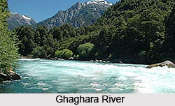
Ghaghara River
Ghaghara River is also called the Gogra, Ghaghara or Ghagra, Nepali Kauriala or Manchu or the Karnali. However, the literal meaning of the river is ' holy water from the sacred mountain', the term Karnali also means "Turquoise River" and is a trans-boundary perennial river that originates on the Tibetan plateau. The Karnali is called K'ung-ch'iao Ho in Chinese. This river near Manasarovar, cuts through the Himalayas in Nepal on its way to the convergence with the Sarda River at Brahmaghat in India where it forms the Ghaghara River. The Ghaghara River is a major left bank tributary of the Ganges. It is the longest and largest river in Nepal with a length of around 507 km and one of the largest affluent of the Ganges.
River course of Ghaghara River
The river rises at an altitude of about 3962 metres, in the
southern slopes of the Himalayas in Tibet, in the glaciers of Mapchachungo.
The river flows south through Nepal as the Karnali River and flows through
one of the most deserted and least explored areas of Nepal. Seti River is a
202 Km long stream feeding this river and drains the western part of the
catchment, and joins the Karnali River in Doti north of Dundras hill.
Another feeder stream is the Bheri river that is 264 Km long and drains in
the eastern part of the Catchment and converges with the Karnali River near
Kuineghat in Surkhet.
Moving southwards across the Siwalik Hills, it splits into
two branches, first Geruva on the left bank and Kauralia on the right bank
near downstream Chisapani to rejoin south of the Indian border and form the
Ghaghra proper. Other tributaries originating in Nepal are the Rapti and the
little Gandak. Another important tributary of Ghaghara is the Sarayu River
in India. This tributary is famous for the location of Ayodhya (the capital
of King Dasarath's Kingdom) on its banks. It flows southeast through Uttar
Pradesh and Bihar to join the Ganga along the town of' Chapra, after a
course of 1080 km. It carries more water than the Ganga before its
convergence. Sarayu River is stated to be identical with the modern Ghaghara
River or as a tributary of it.
Between the mountain ranges of Dhaulagiri and Nanda Devi lies
the Karnali basin. The basin is in the western part of Nepal. In the north,
the tributary lies in the rain shadow of the Himalayas. The basin formed by
the river has a total catchment area of 127,950 sq km of which 45% lies in
India. The growth and development patterns of various indicators associated
to demographic, socioeconomic and development programmes in the Basin in
Nepal are briefly explained. The population of Basin districts in Nepal
increased from 1.9 million in 1971 to 4.7 million in 2001 and almost 250%
increase over three decades. The average population density of the Basin
area have also increased from 87 persons/km2 in 2001 from 53 person/ km2 in
1981.There is steady growth in the cost-effectively active population in
Ghaghara Basin districts.
Glaciers in Ghaghara River Basin
The Nepal Himalaya have 3,252 glaciers and 2,323 lakes above
3,500 m above sea level. These glaciers cover an area of around 5,323 km2
with a probable ice reserve of 481 km3. Out of this, the Karnali River basin
has 1,361 glaciers and 907 lakes, with glaciers covering an area of 1,740.22
km2 and an estimated ice reserve of 127.72 km3.
In India, the administrative districts in the Ghaghara
catchment include places like Ambedkarnagar, Peoria, Azamghar, Basti,
Barabanki, Ballia, Bahraich, Gonda, Faizabad and Gorakhpur Districts.
Districts like Sant kabirnagar Jaunpur, Lakhimpur, kheri, Sitapur of Uttar
Pradesh and Siwan district of Bihar are also along the banks of Ghaghara
River.
Important towns in India along the banks of Ghaghara River
include Akabarpur, Bahraich, Ayodhya Faizabad, Gorakhpur, Barabanki,
Dohrighat, Basti, Deoria , Gonda, Khaililabad, Siddharthnagar, Sitapur,
Saint Kabirnagar and Tanda in Uttar Pradesh and Chapra, Deoria, Siwan,
Saran, Sonepur in Bihar.
Geology of Ghaghara River is unique, since it marks the shift
where the Southern Gondwana land collided with the Northern Eurasian land
lifting the sediments of the then existing Tethys sea and forming the
Himalayas. As a result, the Southern and Northern parts of Nepal show widely
differing formations. One finds the Archean crystalline formations covered
deep beneath the Alluvium of the Terai, the marine sedimentary deposits that
were squeezed to form the high mountains, and also the Siwalik formation
formed by earlier East-West flowing rivers.
Several National parks are constructed along the river
Ghaghara. The protected area of Karnali basin constitutes nearly 14% of the
total Basin area. The Basin area includes 4 out of the 9 National Parks, 1
out of 3 Wild Life Reserves, the only Hunting Reserve, and two out of 6
Buffer Zones of Nepal. The Basin and its influence area alone constitute
around 27% of the total Protected Area, 63% of National Park, 25% of the
Buffer Zone, 100% of the Hunting Reserve and 31% of Wildlife Reserve. The
Shey Phoksundo National Park in Dopa was established in 1984 and is situated
in the trans-Himalayan region of Northwestern Nepal. The copious forests
mainly composed of blue pine, spruce, poplar, cypress, fir and birch and is
habitat for the rare snow leopard and the blue sheep and many species of
birds like the Impeyan pheasant, blood pheasant, cheer pheasant, red and
yellow billed cough, rave, jungle crow and snow partridge. It is considered
as a religious Buddhist site. Rara National Park and Royal Bardia Wildlife
Park are more two parks located along the banks of this river.
The Karnali basin provides the upper range for the Gangetic
river dolphin or the Platanista gangetica. These are the largest freshwater
mammals found on the Indian subcontinent. They are considered susceptible
species. These dolphins survive at the upstream range limit. Dolphins in the
Ghaghara River are particularly vulnerable to threats from habitat
deprivation. The Ghaghara River supports the last potentially practical
population of the Ganges River dolphin in Nepal. These dolphins are at their
furthest upstream range and inaccessible by the Girijapur Barrage, located
about 16 km downstream of the Nepal/India border.
White water rafting is one of the most prominent activities
in the river Ghaghara. Volumes of water bullet down these canyons in a
series of wild rapids. It is so intense that it can only be tackled at low
and medium water. It is considered as one of the finest rafting rivers and
one of the top 3 rivers in the world.
Navigation in River Ghaghara - In the past the Karnali River
was well thought-out to be attractive for the development of navigation
starting from the Indo-Nepal border till the convergence of this river and
the Ganges. The lower reach of this river - called the Ghaghara in India was
used in the past for navigation by steamers. Apart from in the foothills of
the Himalayas where most of the streams were simply fast-moving water
throughout the greater part of the year and not navigable when flowing
rapidly, most of the rivers with steadier currents had boats on them. The
Ganga, the Ghaghara, the Yamuna, the Gomti, the Sharda and the Rapti were
the most important navigable rivers in the Northwestern provinces and Oudh.
(Source : http://www.indianetzone.com/14/ghaghara_river.htm accessed on 10.06.2016)