Kosi River
The Koshi or Kosi River drains the northern slopes of the Himalayas in the Tibet Autonomous Region and the southern slopes in Nepal. From a major confluence of tributaries north of the Chatra Gorge onwards, the Koshi River is also known as Saptakoshi for its seven upper tributaries. These include the Tamur Koshi originating from the Kanchenjunga area in the east, Arun River from Tibet and Sun Koshi from the Gosainthan area farther west. The Sun Koshi's tributaries from east to west are Dudh Koshi, Bhote Koshi, Tamba Koshi and Indravati Koshi. The Saptakoshi crosses into northern Bihar where it branches into distributaries before joining the Ganges near Kursela in Katihar district.
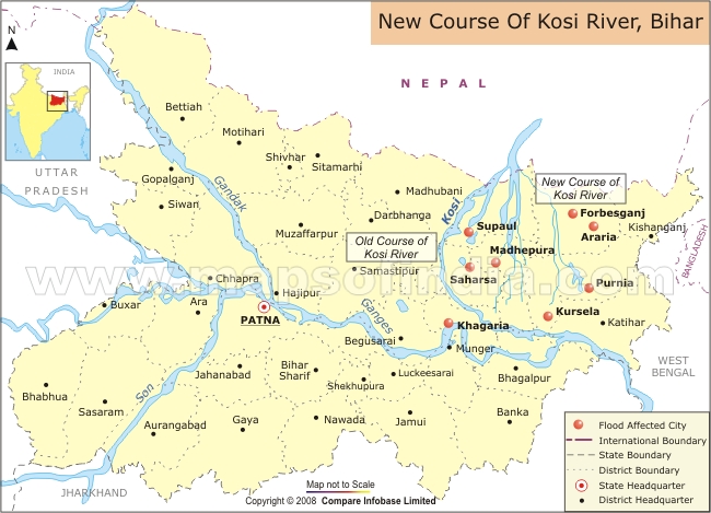
(Source: www.mapsofindia.com accessed on 10.06.2016))
The Koshi is 720 km (450 mi) long and drains an area of about 74,500 km2 (28,800 sq mi) in Tibet, Nepal and Bihar. In the past, several authors proposed that the river has shifted its course for more than 133 km (83 mi) from east to west during the last 200 years. But a review of 28 historical maps dating 1760 to 1960 revealed a slight eastward shift for a long duration, and that the shifting was random and oscillating in nature.
The river basin is surrounded by ridges which separate it from the Yarlung Tsangpo River in the north, the Gandaki in the west and the Mahananda in the east. The river is joined by major tributaries in the Mahabharat Range approximately 48 km (30 mi) north of the Indo-Nepal border. Below the Siwaliks, the river has built up a megafan some 15,000 km2 (5,800 sq mi) in extent, breaking into more than twelve distinct channels, all with shifting courses due to flooding. Kamalā, Bāgmati (Kareh) and Budhi Gandak are major tributaries of Koshi in India, besides minor tributaries such as Bhutahi Balān.
Its unstable nature has been attributed to the heavy silt it carries during the monsoon season and flooding in India has extreme effects. Fishing is an important enterprise on the river but fishing resources are being depleted and youth are leaving for other areas of work.
Geography
The Kosi River catchment covers six geological and climatic belts varying in altitude from above 8,000 m (26,000 ft) to 95 m (312 ft) comprising the Tibetan plateau, the Himalayas, the Himalayan mid-hill belt, the Mahabharat Range, the Siwalik Hills and the Terai. The Dudh-Kosi sub-basin alone consists of 36 glaciers and 296 glacier lakes. The Kosi River basin borders the Tsangpo River basin in the north, the Mahananda River basin in the east, the Ganges Basin in the south and the Gandaki River basin in the west. The eight tributaries of the basin upstream the Chatra Gorge include from east to west:
-
Tamur River with an area of 6,053 km2 (2,337 sq mi) in eastern Nepal;
-
Arun River with an area of 33,500 km2 (12,900 sq mi), most of which is in Tibet;
-
Sun Kosi with an area of 4,285 km2 (1,654 sq mi) in Nepal and its northern tributaries Dudh Kosi, Likhu Khola, Tama Koshi, Bhote Koshi and Indravati.
The three major tributaries meet at Triveni, from where they are called Sapta Kosi meaning Seven Rivers. After flowing through the Chatra Gorge the Sapta Kosi is controlled by the Koshi Barrage before it drains into the Gangetic plain.
Peaks located in the basin include Mount Everest, Kangchenjunga, Lhotse, Makalu, Cho Oyu and Shishapangma. The Bagmati river sub-basin forms the south-western portion of the overall Koshi basin. The Dudh Kosi joins the Sun Kosi near the Nepalese village of Harkapur. At Barāhkṣetra in Nepal it emerges from the mountains and becomes the Koshi. After flowing another 58 km (36 mi) it crosses into Bihar, India, near Bhimnagar and after another 260 km (160 mi) joins the Ganges near Kursela.
The Kosi alluvial fan is one of the largest in the world covering northeast Bihar and eastern Mithila to the Ganges, 180 km (110 mi) long and 150 km (93 mi) wide. It shows evidence of lateral channel shifting exceeding 120 km (75 mi) during the past 250 years, via at least twelve major channels. The river, which flowed near Purnea in the 18th century, now flows west of Saharsa. A satellite image shows old channels with a confluence before 1731 with the Mahananda River north of Lava.
Floods
The Kosi River is known as the "Sorrow of Bihar" as the annual floods affect about 21,000 km2 (8,100 sq mi) of fertile agricultural lands thereby disturbing the rural economy.
The Koshi has an average water flow (discharge) of 2,166 cubic metres per second (76,500 cu ft/s). During floods, it increases to as much as 18 times the average. The greatest recorded flood was 24,200 m3/s (850,000 cu ft/s) on 24 August 1954. The Kosi Barrage has been designed for a peak flood of 27,014 m3/s (954,000 cu ft/s).
Extensive soil erosion and landslides in its upper catchment have produced a silt yield of about 19 m3/ha/year (10 cu yd/acre/yr), one of the highest in the world. Of major tributaries, the Arun brings the greatest amount of coarse silt in proportion to its total sediment load. The river transports sediment down the steep gradients and narrow gorges in the mountains and foothills where the gradient is at least ten metres per km. On the plains beyond Chatra, the gradient falls below one metre per km to as little as 6 cm per km as the river approaches the Ganges. Current slows and the sediment load settles out of the water and is deposited on an immense alluvial fan that has grown to an area of about 15 000 km2. This fan extends some 180 km from its apex where it leaves the foothills, across the international border into Bihar state and on to the Ganges. The river has numerous interlacing channels that shift laterally over the fan from time to time. Without channelisation, floods spread out very widely. The record flow of 24 200 m3/s is equivalent to water a metre deep and more than 24 km wide, flowing at one metre per second.
The Kosi's alluvial fan has fertile soil and abundant groundwater in a part of the world where agricultural land is in great demand. Subsistence farmers balance the threat of starvation with that of floods. As a result, the flood-prone area is densely populated and subject to heavy loss of life. India has more flood deaths than any country except Bangladesh.
Multipurpose Projects
The National Flood Control Policy in 1954 (following the disastrous floods of 1954 in a large part of the Koshi river basin) planned to control floods through a series of dams, embankments and river training works. The Kosi project was thus conceptualized (based on investigations between 1946 and 1955), in three continuous interlinked stages – the first was a barrage to anchor the river that had migrated about 120 km (75 mi) westward in the last 250 years laying waste to a huge tract in north Bihar and to provide irrigation and power benefits to Nepal and India. The second part was to build embankments both below and above the barrage to hold the river within the defined channel. The third part envisaged a high multipurpose dam within Nepal at Barakshetra to provide a substantial flood cushion along with large irrigation and power benefits to both countries. This was followed by the Kosi Agreement between Nepal and India signed on 25 April 1954 and revised on 19 December 1966 to address Nepal's concerns. Further letters of Exchange to the Agreement between the two countries identified additional schemes for providing benefits of irrigation. While the first two parts of the plan were implemented by the Government of India, the Koshi High dam, the linchpin of the whole plan, for various political reasons has yet precluded any action for several years but has since been revived under a fresh agreement, in a modified form for further investigations and studies.
Kosi Barrage and Irrigation
Koshi Barrage, also called Bhimnagar Barrage, was built between 1959 and 1963 and straddles the Indo-Nepal border. It is an irrigation, flood control and hydropower generation project on the Kosi River built under a bilateral agreement between Nepal and India: the entire cost of the project was borne by India. The catchment area of the river is 61,788 km2 (23,856 sq mi) in Nepal at the barrage site. The highest peaks lie in its catchment. About 10% is snow-fed. The Eastern Canal and the Western Canal taking off from the barrage, were designed for a discharge capacity of 455 cubic metres per second (16,100 cu ft/s) to irrigate 6,125 square kilometres (1,514,000 acres) and 210 cubic metres per second (7,400 cu ft/s) to irrigate 3,566.1 square kilometres (881,200 acres), respectively. A hydropower plant has been built on the Eastern Canal, at a canal drop (3.6 km (2.2 mi) from the Koshi Barrage), to generate 20 MW. The Western Kosi Canal provides irrigation to 250 square kilometres (62,000 acres) in Nepal. A valuable bridge over the barrage opened up the East-West highway in the eastern sector of Nepal.
An inundation canal taking off at Chatra, where the Koshi debouches into the plains, has been built to irrigate a gross area of 860 km2 in Nepal.
Kosi Embankment System
The Kosi barrage with earth dams across river, afflux bunds and embankments above and below the river confines the river to flow within embankments. Embankments on both sides downstream of the barrage with a length of 246 km (153 mi) was constructed to check the westward movement of the river. The embankments have been kept far apart, about 12 to 16 km (9.9 mi), to serve as a silt trap.
Sapta Kosi High Multipurpose Project (Indo-Nepal)
The governments of India and Nepal agreed to conduct joint investigations and other studies for the preparation of a detailed project report of Sapta Koshi High Dam Multipurpose Project and Sun Kosi Storage-cum-Diversion Scheme to meet the objectives of both countries for development of hydropower, irrigation, flood control and management and navigation.
Envisaged are a 269-meter (883 ft) high concrete or rock-filled dam, a barrage, and two canals. The dam is on the Sapta Koshi River with an underground powerhouse, producing 3,000 MW at 50% load factor. The barrage is planned for the Sapta Koshi about 8 km (5.0 mi) downstream of Sapta Koshi High Dam to re-regulate the diverted water. The Eastern Chhatra Canal and Western Chhatra Canal, off-take from the barrage site to provide water for irrigation both in Nepal and India and navigation through Koshi up to Kursela and also in the reservoir of Sapta Koshi dam.
A power canal existing Koshi barrage at Hanuman Nagar is proposed for conveying water for irrigation from the Eastern Chatra Canal and also water that may be required downstream for navigation. To utilize the head available between Chatra and Hanuman Nagar barrages for power generation, three canal power houses, each of 100 MW installed capacity are proposed on the power canal.
Extra storage capacity of Sapta Koshi High Dam would be provided to moderate downstream flooding.
Chatra Canal System would provide irrigation to large areas in Nepal and India (particularly in Bihar).
Hydropower
Nepal has a total estimated potential of 83,290 MW with economically exploitable potential of 42,140 MW. The Koshi river basin contributes 22,350 MW of this potential including 360 MW from small schemes and 18750 MW from major schemes. The economically exploitable potential is assessed as 10,860 MW (includes the Sapta Koshi Multipurpose Project [3300MW] mentioned above).
(Source: wikipedia)