NMSHE Study Area
To see Districts,Drainage, Drainage Boundary in NMSHE Study Area Click Here!!!
The Ganges also known as Ganga is a trans-boundary river of Asia which flows through the nations of India and Bangladesh. The 2,525 km (1,569 mi) river rises in the western Himalayas in the Indian state of Uttarakhand, and flows south and east through the Gangetic Plain of North India. After entering West Bengal, it divides into two rivers: The Hooghly River, or Adi Ganga, flows through several districts of West Bengal and into the Bay of Bengal near Sagar Island. The Ganges is one of the most sacred river of India. It is also a lifeline to millions of Indians who live along its course and depend on it for their daily needs.
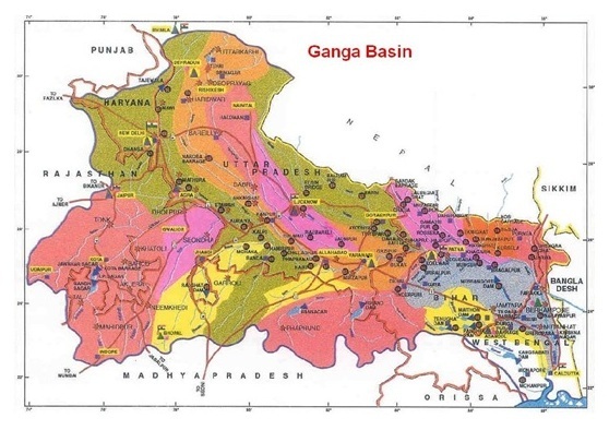
Ganga Basin
The Ganga basin lies between latitude 22°30N and 31°30N, and longitudes 73°30E and 89° 0E. The river extends through India, Nepal and Bangladesh, with a total catchment area of 1,086,000 km2. In India its length is 2,525 km, whilst the catchment area covers 861,404 km2. The surface water resources potential of the Ganga has been assessed at 525 billion cubic meters (BCM) per year (AHEC, 2009). The months of December-May are considered as the lean flow months. Since time immemorial, human communities have settled in the Ganga basin. Several cities and towns have been established at the banks of the river including - Rishikesh, Haridwar, Meerut, Delhi, Agra, Kanpur, Allahabad, Varanasi, Patna and Kolkata. For the millions of people residing in the Ganga basin, the major source of surface water is the Ganga. It is becoming increasingly clear that, regionally and globally, freshwater ecosystems are being more heavily impacted by human uses, and that their biodiversity is becoming even more severely endangered than that of terrestrial or marine systems. One of the key threats to the upper Ganga and other Himalayan rivers is water abstraction for hydropower, irrigation, urban and industrial needs. To address this, the concept of ‘minimum flows’ has recently been proposed and is being implemented in some river basins. However, this is still not based on a full understanding of the regime of flows needed in a river to maintain its ecological integrity as well as support human needs. The study in the Upper Ganga was also important because of the impact of a series of dams and barrages on the habitat requirements for maintaining biodiversity. As a whole, this stretch of the river represents most of the problems the Ganga is facing today, such as diversions for hydropower, water abstraction from dams and barrages, agricultural pollution, industrial pollution, sewage disposal from cities, and the inflow of the most polluted tributaries of the Ganga, such as the Ramganga and Kali rivers. In addition to these threats, the presence of endangered aquatic biodiversity such as two species of mammals (river dolphins, otters), crocodiles (gharial and mugger), 12 species of turtles and 75 species of fishes (including mahseer, Tor putitora) makes this a unique ecosystem. (Source: WWF-India, 2012)
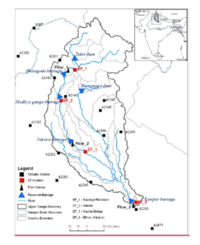
Upper Ganga Basin
The upper Ganga region is being considered in the 800 km stretch of the river Ganga from Gangotri to Kanpur. It is in sections of this upper stretch of the Ganga that the most serious problems of water quality and quantity are recorded, whereas in the middle reaches, i.e. downstream of Allahabad, once the Yamuna joins the Ganga, the quality and quantity improves.
The majority area of upper Ganga lies is in hilly state Uttarakhand. The elevation ranges in this state varies from 210 to 7817 m. The state shares its border with China (Tibet) in the north, Nepal in the east, inter-state boundaries with Himachal Pradesh in the west and north-west and UP in the south. Broadly, the region constitutes of 13 districts falling in two major administrative units, viz., Garhwal (north-west portion) and Kumaon (south-east portion). Garhwal Division consists of seven districts, i.e. Dehradun, Haridwar, Uttarkashi, Tehri, Pauri, Rudraprayag and Chamoli, while the remaining six districts, viz., Pithoragarh, Bageshwar, Almora, Nainital, Champawat and Udham Singh Nagar, fall in Kumaon Division. Hindi, Garhwali and Kumauni are commonly spoken languages in the state. For NMSHE project, the study area of upper Ganga is taken up to Rishikesh.
| General Profile | |
|---|---|
| Main crops | Rice, barley, maize |
| Main fruits | Apple, litchi, plum, peach, malta |
| Main rivers | Bhagirathi, Alaknanda, Mandakini, Pindar, Tons, Yamuna, Kali, Bhilangna, Sarayu, Ramganga |
| Main tourist and historic places | Nainital, Mussoorie, Pauri, Almora, Ranikhet, Khirsu |
| Main religious places | Badrinath, Kedarnath, Gangotri, Yamunotri, Panchakedar, Panchabadari, Panchaprayag, Haridwar, Rishikesh, Hem Kund Sahib |
| Key industries | Auto and auto-components, agro and food processing, paper, machinery and equipment, pharmaceuticals, FMCG, tourism, hydro power, saw mills, plywood and resin factories and other forest-based industries |
| S.No. | Zone/Altitude | Farming situation | Soil | Rainfall (mm/ year) | Districts | Principal farm produce and livestock |
|---|---|---|---|---|---|---|
| 1. | Zone A. upto 1.000 m | Tarai irrigated | Alluvial | 1400 | U.S. Nagar, Haridwar | Rice, wheat, sugarcane, lentil, chickpea, rapeseed- mustard, mango, litchi, guava, peach and plums. Livestock: Buffalo and cattle |
| Bhabhar irrigated | Alluvial mixed with boulders | 1400 | Nainital, Dehradun and Pauri Garhwal | Rice, wheat, sugarcane, rapeseed-mustard, potato, lentil, mango, guava | ||
| Irrigated lower hills(600-1000 m) | Alluvial sandy soil | 2000-2400 | Champawat, Pauri, Dehradun. Garhwal. Nainital, Garhwal. Tehri | Rice, wheat, onion, chillies, peas, potato. Radish, cauliflower, pulses, oilseeds, soybean, mango, guava. Plums and peaches. Livestock: Buffalo and cattle | ||
| Rain-fed lower hills (600-1000 m) | Residual sandy loam | 2000-2400 | Champawat, Pauri Dehradun. Garhwal. Bageshwar. Nainital, Tehri | Finger millet, maize, rice, wheat, pulses, mango, guava, plums and peaches. Livestock: Buffalo, cattle and goat. | ||
| 2. | Zone B, 1000-1500 m | Mid hills, south aspect (1000-1500 m | Sandy loam | 1200-1300 | Champawat, Nainitai, Almora. Dehradun, Tehri, Bageshwar | Rice, finger millet, wheat, potato, tomato, peas. Cole crops, pulses, peaches and plums. Livestock: Cattle, sheep and goat. |
| 3. | Zone C, 1500-2400 m | High hills (1500-2400 m) | Red to dark | 1200-2500 | Pithoragarh. Almora, Chamoli, Bageshwar | Amaranth, finger millet. French beans, ole crops, potato, peas, pear, peaches, plums, apple, stone fruits. Livestock: Cattle, sheep and goat. |
| 4. | Zone D, >2.400 m | Very high hills | Red to black clay | 1300 | Pithoragarh. Chamoli, Uttarkashi | Amaranth, peas, buckwheat, cole crops, apple and potato. Livestock: Sheep, goat. |
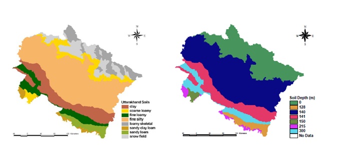
Soils and soil depth map of Uttarakhand by NBSS & LUP1
Soil is one of the most important natural resources and the biodiversity of a region strongly depends upon soil and climatic elements. Soil also greatly influences the productivity (performance) of agro-ecosystems. Soil resources in Uttarakhand vary from the deep, alluvial and fertile soils of the Tarai tract to the recently laid down alluvium of the dun valley; the thin fragile soil of the Shivalik hills; the black soils of the temperate zone; and the arid, bare soil of the inner dry valleys. Soils in the bottom of valleys are more fertile than those found on the ridge top due to the presence of a large quantity of humus, mineral nutrients and moisture and due to the suitable soil depth. This natural resource is depleting gradually, day by day, as soil erosion in the area is increasing with the increase in deforestation and degradation.
On the basis of soil texture, the National Bureau of Soil Survey & Land Use Planning (NBSS&LUP), Nagpur has divided the soils of Uttarakhand into eight different categories, namely sandy loam, sandy clay loam, fine loam, fine silt, clay, coarse loam, loamy skeletal and snow field. Owing to its largely mountainous regions, the state is endowed with unique ecosystems. The northern region of the state is part of the great Himalayan range, covered with snow and glaciers. Two of the Indian sub-continent’s major rivers – the Ganga and the Yamuna – also originate from the glaciers of Uttarakhand. Other parts of Uttarakhand are covered with dense forests that make up the bulk of the natural resources base.
Owing to its largely mountainous regions, the state is endowed with unique ecosystems. The northern region of the state is part of the great Himalayan range, covered with snow and glaciers. Two of the Indian sub-continent’s major rivers – the Ganga and the Yamuna – also originate from the glaciers of Uttarakhand. Other parts of Uttarakhand are covered with dense forests that make up the bulk of the natural resources base.
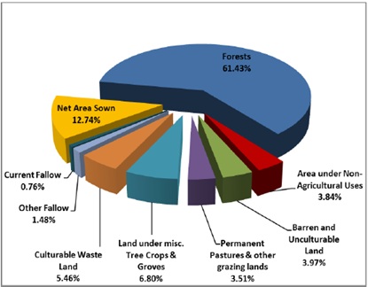
Land use pattern
As in most other hill economies, the people of Uttarakhand practice integrated systems of farming, forestry, horticulture, livestock rearing and off-farm activities.
The climatic conditions experienced in Uttarakhand vary from hot and moist subtropical in the southern part to cold alpine in the upper reaches of the Himalayan Mountain in the northern parts. Warm and cool temperate climate persists over the areas between southern and northern parts of the state. The climate at particular place in the state is influenced by (a) Altitude/ elevation (b) Latitude or location (c) Slope and topography. The climate of Uttarakhand is sharply demarcated in case of two distinct divisions the predominant hilly terrain and the smaller plain region. The areas of high hills even become inaccessible in winter due to extreme cold of climate causing prolonged snowfall. The mountain range itself exerts an appreciable extent of influence on monsoon and rainfall patterns. Cold alpine climate is experienced at higher reaches where summers are cool and winters are harsh. At altitudes over 4800 m, the climate is bitterly cold with temperatures consistently below the freezing point of water and the area is perennially shrouded in snow and ice.
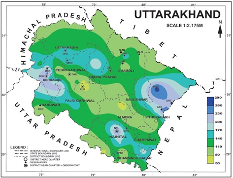
Temperature regimes in Uttarakhand
The state lies in the mountainous region except for some plain areas in the districts along the southern boundary of the state. The temperature in the state therefore, varies considerably from place to place in the state accordingly elevation, location, slope and topography. The temperature starts to rise from March and steadily rises till it reaches its peak in May to the middle of June, when the mean maximum temperature in southern part of the state is at about 34°C to 38°C and mean minimum temperature is at about 20°C to 24°C. At places at about 2 km altitude, mean maximum and mean minimum temperatures are around 23 - 24°C and 15°C respectively. On individual days maximum temperature rises to 42°C in the valleys and southern part of the state and 30°C in stations at about 2 km elevation. The highest maximum temperature on record at any individual station was 47.4°C at Roorkee observatory on 22nd May 1978.. The lowest minimum temperature on record at any individual station was -15.1°C at Joshimath observatory on 15th January 1974.
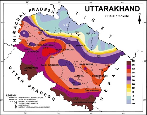
Annual Normal Rainfall in Uttarakhand
The region receives rainfall mainly due to low pressure areas and monsoon depressions originating in the Bay of Bengal during the southwest monsoon season. During the monsoon season most of the depressions originating in the Bay of Bengal cross inland and move north westwards or westwards over the state, some of them reach near the hilly districts. The total annual rainfall for the state as a whole is about 133 cm and total annual number of rainy days are about 63. The precipitation in the state occurs in the form of rain and snow. Snowfall occurs mostly in winter months from December to February associated with western disturbances. January is the month with the heaviest snowfall. The rainfall in the state varies from place to place due to its rugged topography. Pithoragarh district in Kumaon division received the maximum amount of precipitation i.e. at about 177cm in a year, whereas Almora district in Kumaon division received the minimum amount of precipitation i.e. at about 97 cm in a year. It is seen that the rainfall generally increases in the valley regions towards the hills and decreases beyond the highest range (leeward side).
The rivers play a vital role in the economic, cultural, social and environmental issues of India. Major source of water in rivers in Uttarakhand state is glacier melt. The main drainage system of Uttarakhand which contribute water to the rivers has been grouped into the following six catchments:
Yamuna Catchment
The Yamuna River originates from the base of Bandar punch peak. It has carved a deep V-shaped gorge. The Yamuna cuts across the Nag Tibba range and Mussoorie range near a place called Yamuna Bridge. The rivers Tons, Pabar and Aglar are its important tributaries. It passes through the Doon valley at its western boundary.
Bhagirathi Catchment
This is one of the two rivers that join to form the River Ganga. It originates from the snout of the Gangotri glacier at Gaumukh, which is at the base of Chaukhamba peak. The Bhagirathi River has cut a deep gorge across the granitic rocks of the higher Himalaya of Garhwal. Its main tributaries are the river Janhavi and the Bhilangna.
Alaknanda Catchment
The Alaknanda River joins the River Bhagirathi at Devprayag to form the River Ganga. It originates from the eastern slopes of Chaukhamba, from the Bhagirathi Kharak and Satopanth glaciers. The river flows by the side of the Badrinath temple. Its main tributaries are the Khiraonganga, Pindar Dhauliganga, Birahi, Nandakini, Mandakini, etc. It has formed a broad valley at Srinagar (Garhwal).
Mandakini Catchment
It comes out from the Mandakini glacier near Kedarnath. It cuts through a gorge of glacial debris. The river has formed road terraces at Augustmuni and Tilwara. At Tilwara, it is joined by the River Lastar Gad. The River Mandakini joins the river Alaknanda at Rudraprayag.
Pindar Catchment
The River Pindar originates from the Pindari Glacier, which is located between Nanda Devi and Nanda Kot peaks. The Sundardhunga River joins the Pindar near Dhakuri. The Pindar joins the River Alaknanda near Karanprayag.
Kali Catchment
The River Kali forms the boundary between Kumaon and Nepal. The Towns of Champawat and Pithoragarh are situated on the back of the Kali River. Its important tributaries are Darma and Saryu rivers
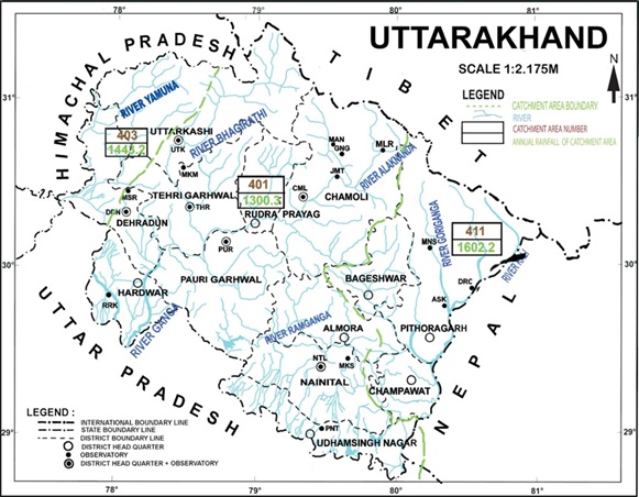
Map of Uttarakhand showing rivers with catchment area.
I. Bhagirathi River
The Bhagirathi River is a Himalayan River which flows in Uttarakhand state. It is one of the two headstreams of the pious Ganga River. This river has a length of 205 km and basin about 6,921 km2. According to Hindu mythology, it is believed that Bhagirathi River is the source-stream of Ganga River. Whereas, hydrology report states Alaknanda, the other headstream as the source stream, because of its great length and discharge.
The headwaters of Bhagirathi River are formed at Gaumukh, perched at an elevation of 3,892 metres about 12,769 feet above sea level, at the foot of Gangotri glacier and Khatling glaciers in the Garhwal Himalaya. It is then joined by its various tributaries, Kedar Ganga at Gangotri, Jadh Ganga at Bhaironghati, Kakora Gad and Jalandhari Gad near Harsil, Siyan Gad near Jhala, Asi Ganga near Uttarkashi and Bhilangna River near Old Tehri.
Bhilangna, which is the major tributary of Bhagirathi River, rises at the foot of the Khatling Glacier, perched at an elevation of 3,717 metres about 12,195 feet above sea level. It is approximately 50 km south of Gaumukh. The Bhilangna river flows about 205 km from its source, before meeting Alaknanda River at an elevation of 475 metre about 1,558 feet above sea level, in the town of Devprayag. The downstream of this confluence is considered pious by the Hindus. The highest point of the Bhagirathi basin is Chaukhamba I. The famous Tehri Dam lies at the confluence of Bhagirathi and Bhilangna River near Tehri Garhwal.
Bhilangna River :
Bhilangna River in Uttarakhand India is a major tributary of Bhagirathi River, which is the source-stream of Ganga River. The length of this river is 80 km. Bhilangna River rises at the foot of Khatling Glacier, perched at an elevation 3,717 metres, about 12,195 feet above sea level. The river is approximately 50 km south of Gaumukh, which is considered as the traditional source of Bhagirathi and Ganga rivers. It flows into Bhagirathi at Old Tehri, the site of the Tehri Dam. Bhilangna meets its major tributaries namely Bal Ganga at Ghyansali at 976 metres about 3,202 feet above sea level.
II. Alaknanda River
The Alaknanda River flowing in Uttarakhand is one of the two headstreams of holy river Ganga. The source of Alaknanda River is the confluence of Satopanth Glacier and Bhagirathi Kharak Glacier. The length of Alaknanda River is 190 km (Devprayag to Chamoli 120 km and Chamoli to Badrinath 100 km) and the basin is about 10,882 km square.
The river flows in Garhwal division of Uttarakhand and passes through Chamoli, Rudraprayag, and Pauri Garhwal districts. Several rivers flowing in the Garhwal division of Uttarakhand state merges with Alaknanda River at PanchPrayag, also known as “holy confluence of the rivers”. Alaknanda meets Dhauliganga River at Vishnuprayag, Nandakini River at Nandaprayag, Pindar River at Karnaprayag, Mandakini River at Rudraprayag then it meets Bhagirathi River at Devprayag, where it officially becomes Ganga River. Its left-bank tributaries are Saraswati, Dhauliganga, Nandakini, Pindar and its right-bank tributary is Mandakini. The towns along the banks of River Alaknanda are Badrinath, Vishnuprayag, Joshimath, Chamoli, Nandaprayag, Karnaprayag, Rudraprayag, Srinagar and Devprayag.
Mandakini River :
Mandakini River emerges from Chorabari Glacier near Kedarnath in Uttarakhand, India. This river is a tributary of Alaknanda River and is fed by Vasukiganga River at Sonprayag. The river merges with Kaliganga near Kalimath temple and with Madhyamaheshwar Ganga near Ukhimath. The Mandakini River drains into Alaknanda at Rudraprayag. Alaknanda then makes its way to Devprayag and merges with Bhagirathi rivet to form the mighty Ganga River. This river has a length of 72 km.
III. Ganga River
The Ganga River also referred to as the Ganges emerges from Devprayag traversing through Biyasi Rishikesh and exists at Haridwar, in Uttarakhand. The source of Ganga River is Gangotri Glacier, Satopanth Glacier, Khatling Glacier and the melted water from the snow-clad peaks of Nanda Devi, Trishul, Kedarnath, Nanda Kot and Kamet.
The Ganga River begins at the confluence of the holy rivers Bhagirathi and Alaknanda at Devprayag. The length of this river in Uttarakhand is about 96 km. Ganga flows through the Himalayan Valley, originates from the mountainous terrains of Rishikesh and debouches onto the Gangetic Plain at the holy city of Haridwar. The left bank tributaries of Ganga are Ramganga, Gomti, Ghaghara, Gandaki, Bagmati, Koshi, Mahananda. Its right bank tributaries are Yamuna, Tamsa, Son and Punpun.
The holy Ganga River gushes from Gaumukh in Gangotri Glacier and flows in eternity to nourish the Indo-Gangetic plain. The towns along Ganga River are Gangotri, Rishikesh, Haridwar, Allahabad and Varanasi.Many small and big streams comprise the headwaters of Ganga, but the six longest streams and their five confluences are considered sacred. The six headstreams are Alaknanda, Dhauliganga, Nandakini, Pindar, Mandakini and Bhagirathi rivers. The Dhauliganga joins Alaknanda at Vishnuprayag, Nandakini joins at Nandprayag, Pindar joins at Karnaprayag, Mandakini joins at Rudraprayag and finally Bhagirathi joins the Alaknanda at Devprayag, thus forming the Ganga River.
Ramganga West River :
Ramganga West River emerges from Dudhatoli ranges in PauriGarhwal district of Uttarakhand. The length of Ramganga River is 155 km and the catchment area of the basin is 30,641km square. This river flows to the southwest from Kumaun Himalayas. Ramganga is a tributary of Ganga, which originates from the high-altitude zone of 800m to 900 m. It passes through Corbett National Park, near Ramnagar in Nainital district and descends to the plains.
The entire river flows in Uttarakhand and Uttar Pradesh states. The important tributaries of Ramganga are Kho, Gangan, Aril, Kosi and Deoha also known as Gorra. Ramganga flows through various places and consolidates many places into one. It passes through Taal, Chaukhutia, Bhagoti, Masi, Bhikyasen etc. which comes under Kumaon region.
IV. Yamuna River
The Yamuna, an Inter-state river, is the most important tributary and Western -most river of Ganga river-system, joining it on the right bank. The whole Yamuna basin lies between the north latitudes 22° 35' to 31° 25' and east longitudes 73° 25' to 81° 50' and extends over an area of 2,26,755 sq.km (excluding the Chambal) lying between the Himalayas in the north and the Vindhyas in the south . In the east, it is separated by a ridge from the Ganga basin and in the west by another ridge from the Luni and Ghaggar basins.
River Yamuna rises in Tehri Garhwal district of Uttarakhand from Yamunotri Glacier (30° 58' N 78° 27' E) near Bunderpunch at an elevation of 6,320 m in Mussoorie range of Lower Himalayas. Many small streams like Rishi Ganga, Ulta Ganga, Hanuman Ganga and several others join it in the mountains. In the first 120 km, the river flows in south westerly direction and is joined by the largest Himalayan tributary, Tons at the right bank near Dak Pathar below Kalsi on south-west fringe of Mussoorie range. River Tons carries almost double discharge than the main river Yamuna at its confluence. River Pabar is an important tributary of Tons, which joins at Tuini. Giri, another important Himalayan Tributary rises near Shimla and joins Yamuna on the right bank near Paonta Sahib. River Asan joins Yamuna on the left bank below Paonta Sahib. The combined stream forces its way through Shiwalik range of hills to emerge into the plains near Hathni Kund. At this place a 100 years old weir is existed; from where the famous Eastern Yamuna canal, Western Yamuna canal take off for irrigation purposes in Uttar Pradesh and Haryana respectively. From Faizabad it flows in south-westerly direction for about 104 km and then turns south from Abidauii in Muzaffar Nagar district of Uttar Pradesh for 128 km to reach to Okhla in Delhi territory, where Agra Canal takes off from Okhla Head works. No major tributary joins Yamuna between HathniKund to Delhi. Above Hathni Kund, the catchment of Yamuna is fan-shaped and covers an area of 11060 sq km.
V. Kosi River
Kosi is a Himalayan river which originates from DharpaniDhar (2,500 m) in Baramandal region of Almora district in Kumaon, Uttarakhand. After emerging from DharpaniDhar, Kosiriver flows through the valleys and towns of Ramnagar, Uttarakhand, then it enters the Tarai regions of Uttar Pradesh, where it joins Ramganga river. Kosi River is referred to as “Kosila” by the locals. The length of this river is 168 km. The farmers of Kumaon region use the water of this river for cultivating of wheat, rice and other crops. The known places situated nearby this river are Bujan, BetalGhat, Corbett National park, Garjiya Devi temple, Amdana, Ramnagar etc.
VI. Sharda River
River Sharda is very important tributary of right side bank of river Ghaghra. It is formed by a combination of a number of tributaries near Burmadeo Mandi in Nepal and enters-in the plains area near Sarkhana village.
Its tributaries are Kali, Khopang, Sarju, Ladiya and Uil rivers on the right bank and Chamlia river on the left bank. It flows in the districts Almora, Pithoragarh & Champawat in Uttarakand and Pilibhit, Lakhimpur Kheri and Sitapur in U.P. It joins the river Ghaghra at up-stream of Elgin bridge site in District Barabanki. The total catchments area is about 20,720 Sq. kms. out of which only 1/5 part lies in the plains. The river has a total length of about 546.5 km out of which 223 km. lies in Nepal. The flood water of river Sharda is being controlled by Sharda Barrage. This is situated at the up-stream of Sharda nagar site in district Lakhimpur Kheri and maintained by State government
Kali River :
The Kali River also known as “Kutiyangdi” or “Mahakali River” is a Himalayan river, which flows through Uttarakhand. The traditional source of Kali River is Lipmpiya Dhura in Pithoragarh district of Uttarakhand, 3,600 metres about 11,800 feet above sea level. The length of this river is 252 km and the basin area is 18,140 square km. Kali River is the headwater stream of the Mahakali River. The river got its various names from the inhabitants, residing on the different side of the Indo-Nepal border. The Kali River is referred to as Kali Gad or Kali Ganga in Uttarakhand, where it separates Nepal’s western border with India.
The Kali leaves the Hill Region at Jogbudha Valley and meets the two tributaries namely Ladhiya and Ramgun. Then it enters the lower Shiwalik Hills. There is a tiny hamlet called Tanakpur, located above the Dam of Sharda Reservoir. The river exits the last hills into the Terai plains and crosses two towns namely Banbasa and Mahendranagar also known as BhimDatta.The Kali River descends from 3,600 meters (11,800 feet) at Kalapani to 200 meters (660 feet) on entering Terai plains.
Saryu River :
Saryu (Sarju) is a Himalayan river which flow in the Kumaon region of Uttarakhand. The source of this river is Sarmool and the end point is Pancheshwar. In local dialect, SaryuRiver is referred to as ‘Sarju’. Bhuni, Sup and Khati are the famous ‘Ghats’ situated on the Bank of this river. The SaryuRiver flows to the south-west direction and at TallaDanpur region it meets with ‘Kanal Gad’. After covering some distance a stream called ‘Punaar Gad’ also joins it.
After flowing through the enchanting valleys of MallaKatyur, the confluence of Lahur and Saryuriver take place. At Bageshwar, which is a famous city of Uttarakhand it meets with Gomti River. Near the confluence of these two rivers ancient Bagnath Temple is located. After crossing Bageshwar city, the small tributaries like Bhrapadigad, Chaugarkha-Ki-Ghat Gad, Jalaurgad, Bhaurgad, Alaknandi, Saniyangad and Panar River joins SaryuRiver. At Rameshwar confluence of Saryu and eastern Ramganga River takes place. The eastern Ramganga has three times more water than Saryu River.
Reservoirs (Dams/ Barrages)
Gharwal Region :
In gharwal region most of the water bodies are in the form of artificial reservoirs which further serves the different purpose i.e. irrigation, power generation, water s upply, ground water recharge, navigation etc. Few important reservoirs are as follows:
1. Maneri Bhali
The Maneri Dam is a concrete gravity dam (1st phase) on the Bhagirathi River located at Maneri, 8.5 kilometers east of Uttarkashi in Uttarkashi district, Uttarakhand, India. The primary purpose of the dam is to divert water into a tunnel which feeds the 90 megawatts run-of-the-river Tiloth Power Plant. The effective storage capacity of 1st stage reservoir is 510 X103 m3. Reservoir area is 180 X 103 m2.
In the second stage, water is supplied to the Dharasu power station from the Bhagirathi River using Bhali (Joshiyara) Dam located upstream near Bhali.
2. Tehri Dam
Tehri Dam & HPP (1000 MW) comprises a 260.5 M high Earth & Rockfill dam which is one of the highest dams of its type in the world, a Spillway System designed for PMF of 15540 cumecs and a drop of 220m, having one Chute Spillway and four Shaft Spillways and an underground Power House housing four Turbine/ Generator sets of 250 MW each, designed to operate with a head variation of 90 m. The effective storage capacity reservoir is 2615 Mm3. Reservoir area is 42 Mm2.
Project was commissioned in 2006-07 and all four machines of Tehri Power Station are under commercial operation. Besides providing much needed power to the Northern Grid, the command area is availing irrigation benefits from the Project and drinking water is being supplied to Delhi and UP.
Benefits from the Tehri Hydro Power Complex :
- Irrigation (additional) - 2.70 Lac ha.
- Stabilization of existing irrigation (besides above) - 6.04 Lac.ha.
- Additional Generation in downstream Projects- 200 MU
- 300 Cusecs (162 million gallons per day) of drinking water for Delhi which will meet the requirements of about 40 lac people.
- In addition, 200 Cusecs (108 million gallons per day) of drinking water for towns and villages of U.P. which will meet the requirement of 30 Lac people.
- Flood Moderation
- Integrated development of Garhwal region, including construction of a new hill station town with provision of all civic facilities; improved communication, education, health, tourism, development of horticultures, fisheries, and afforestation of the region.
3. Koteshwar Dam
Koteshwar Hydro-Electric Project (400 MW), located 22 km downstream of Tehri, is an integral part of Tehri Power Complex comprising of Tehri Dam & HPP (1000 MW), Tehri PSP (1000MW) and Koteshwar HEP (400MW) to develop Hydro-electric potential of river Bhagirathi. It will facilitate the functioning of Tehri Power Complex as a major peaking station in Northern grid as reservoir created by Koteshwar Dam having a live storage capacity of 35.0 Mm3 will function as lower (balancing) reservoir for Tehri PSP. Reservoir area is 29 Mm2.This project is also regulating water releases from Tehri reservoir for irrigation purpose.
Benefits :
- Peaking Power- 400 MW.
- Design Energy-1155MU (90% dependable year).
- Reutilization of water releases from Tehri Reservoir for irrigation Purposes.
- Koteshwar Reservoir will funtion as the pre requisite lower reservoir for Tehri PSP.
4. Ichari Dam
The Ichari Dam is a concrete gravity dam on the Tons River 13 km north of Dakpathar in Uttarakhand, India. The primary purpose of the dam is hydroelectric power production and it is a run-of-the-river-type. The dam is a 59 m tall and 155 m long concrete gravity type with a structural volume of 181,000 m3.The dam's reservoir has 8,930,000 m3capacities, of which 5,110,000 m3 is active (or "useful") capacity. The surface area of the reservoir is 8 km2.
The dam diverts water to the Chibro Power Station (240 MW) which is then returned to the Tons River before being fed to the Khodri Power Station (120 MW).
5. Ramganga Dam
The Ramganga Dam, also known as the Kalagarh Dam, is an embankment dam on the Ramganga River 3 km upstream of Kalagarh in Pauri Garhwal district, Uttarakhand, India. It is located within the Jim Corbett National Park. The dam is a 128 m tall and 715 m long earth and rock-fill embankment dam with 10,000,000 m3 of fill. The effective storage capacity reservoir is 218.77 Mm3. Reservoir area is 19.72 Mm2. It supports a 198 MW power station and provides water for the irrigation of 57,500 ha (142,086 acres) of farmland. In addition, it provides for flood control and recreation.
The project aims at providing irrigation facilities to about 6 lakh hectares of land in western and central Uttar Pradesh, supplying 200 cusecs of drinking water to the city of Delhi and controlling flood menace in central and western Uttar Pradesh.
6. Vishnuprayag Dam
The Vishnuprayag Hydro-electric Project - a run-of-the river scheme is located across river Alaknanda in district Chamoli of Uttaranchal. It is a gravity dam having length of 69.75 m. The Project utilizing the waters of river Alaknanda has an underground power station with an installed capacity of 400MW (4x100MW). The effective storage capacity of reservoir is 75.6 X10³ m3. Reservoir area is 21.17 X 10³ m2.
7. Lakhwar Vyasi Dam
75 kilometers from Dehradun lies Lakhwar Vyasi hydroelectric project, which is under construction. This project was developed on Yamuna River. It will generate 927 MU power and irrigate 40,000 hectare of land, in underdeveloped area of Uttaranchal & West U.P. It has two parts: -
(a) 192 meters high Lakhwar Dam and 300 (3*100) MW underground powerhouse with an annual energy generation of 612.93 MU in a 90% dependable year. The effective storage capacity of reservoir is 330.66 X10³ m3. Reservoir area is 9570 X 103 m2.
(b) 80 meters high Vyasi Dam, 2.7 kms long power tunnel and 120 (2*60) MW Hathyari Power House with an annual energy generation of 375.22 MU in a 90% dependable year. The maximum gross head of the scheme is 369 m and the nominal discharge is 156 m3/s. The effective storage capacity of reservoir is 3710 X103 m3. Reservoir area is 729 X 103 m2.
8. Srinagar Dam
The dam is located on Alaknanda River in Srinagar district. The length of the dam is 248.00 m and height of dam is 90 m above lowest foundation level. The dam is under construction. The effective storage capacity of reservoir is 8000 X103 m3. Reservoir area is 4500 X 103 m2.
9. Dakpathar Barrage
The Dakpathar Barrage is a concrete barrage across the Yamuna River adjacent to Dakpathar in Uttarakhand, India. In a run-of-the-river scheme, the barrage serves to divert water into the East Yamuna Canal for hydroelectric power production at the Dhakrani and Dhalipur Power Plants.
10. Asan Barrage
The Asan Barrage is a man-made lake, developed in 1967 when the Dhalipur power house was under construction. Lying at the confluence of the rivers Yamuna and Asan, it is popularly known as Dhalipur Lake and enjoys distinct summer and winter seasons. This wetland covers the area of approximately four square kilometers. A blue green lake, 43 kilometers from Dehradun, has become a hot spot for nature-lovers and birdwatchers. It has acquired a name of its own in recent years since hundreds of birds, including the migratory ones, visit this man-made sanctuary.
11. Bhimgoda Barrage
The Bhimgoda Barrage, also referred to as the Bhimgoda Weir or Bhimgoda Head Works, is a barrage on the Ganges River at Har ki Pauri near Haridwar in Haridwar district, Uttarakhand, India. The catchment area of the reservoir is 23,000 km2. The primary purpose for the barrage is irrigation but it also serves to provide water for hydroelectric power production and control floods. The area behind the barrage is known as the Neel Dhara Bird Sanctuary and is a popular destination for various water birds and tourists.
A glacier is more or less permanent and naturally accumulating mass of ice and compacted snow that moves in response to gravity and undergoes internal deformation. The Himalaya constitutes one of the most important glacier systems in the world, where more than 5000 glaciers (Indian part) of different sizes and shapes are located; nearly 968 being present in the Uttarakhand Himalayas. Since large part of the main Himalayan range lie above the snow line that generally occurs at an elevation between 4500-5400 meters, the Himalayan glaciers lie at formidable high altitudes and form a unique setting compared to other glaciers of the world. Their scientific study assumes foremost importance for the development of water resources; climate/weather prediction and understanding of the ecological system coupled with resource development and associated hazards.
Himalayan Glaciers :
The Himalayan glaciers contribute fresh water to the main river systems of the Indian sub-continent. It is estimated that 38221 km2 of Himalayan ranges are glaciated. Glaciers inventory data (Geological Survey of India) has identified more than 5000 glaciers in the Indian part of the Himalaya comprising the territories of Jammu and Kashmir, Himachal Pradesh, Uttarakhand, Sikkim and Arunachal Pradesh. Distribution of these glaciers along the Himalayan arc is uneven with the concentration of glaciers being higher in the NW than NE part of the Indian Himalaya. Such complexity is due to criss-cross mountain alignment, altitudinal variations and different climatic environments. These characteristics can be defined by the fluctuation in regional snow/firn line limit that ranges in altitudes from 4500 to 5700 m.
The records pertaining to fluctuating glacial limits are only 150 years old. Mayeswki and Jeschke (1979) studied 122 glaciers of the Himalaya and Karakoram region and concluded that most of the glaciers are retreating. Much significant work on the recession of Himalayan glaciers has been carried out by the Indian scientists during the last few decades. These studies have revealed that the glaciers are retreating with an average rate of 18 to 20 m/yr. It has also been observed that the recession rates of both small (<5 km) and large (>10 km) glaciers are more or less same, which indicates that the future of small glacier is not very encouraging.
Uttarakhand Glaciers :
There are 968 glaciers covering 3,133 km2 with the approximate 213.74 Km3 volume of water in solid form and are existing in four river major river basin of the state. This shows ~7.2% glacier area of entire Indian Himalaya exists in Uttarakhand. These glaciers are important as water discharge from these glaciers and snow melt contributes to a significant amount to the overall river runoff of Ganga and its tributary rivers and provide noteworthy contribution in hydropower development in Uttarakhand state. The Bhagirathi River is the main source stream of the Ganga River, which originates from the snout (Gaumukh; ~3950 m a.s.l.) of Gangotri Glacier, the largest valley glacier (~30 km) in the Garhwal Himalaya. The headwater of the Alaknanda River originates from the snouts of Bhagirathi Kharak and Satopanth glaciers. The Alaknanda basin has 407 glaciers covering ~1204 km2, whereas the Bhagirathi basin contains 238 glaciers covering ~755 km2 (Sangewar and Shukla, 2009).
| S. No. | Major Basin | No. of Glaciers | Area (km2) | Volume (Km3) | Snout Elevation (m. asl) |
|---|---|---|---|---|---|
| 1. | Yamuna | 52 | 205 | 12.20 | 4040 |
| 2. | Bhagirathi | 238 | 755 | 67.02 | 4150 |
| 3. | Kali | 271 | 969 | 43.77 | 4130 |
| 4. | Alaknanda | 407 | 1204 | 90.75 | 4240 |
| Total | 968 | 3133 | 213.74 |
Table of glaciers of Uttarakhand
| State | Glaciers | Area (km2) | Average size (km) | Glacier in the state (%) |
|---|---|---|---|---|
| J&K | 5262 | 29163 | 55.0 | 55.0 |
| Himachal | 2736 | 4516 | 3.35 | 28.0 |
| Uttarakhand | 968 | 2857 | 3.87 | 10.0 |
| Sikkim | 449 | 706 | 1.50 | 5.00 |
| Arunachal | 161 | 223 | 1.40 | 2.00 |