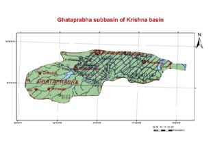
The Ghataprabha river originates in the Western Ghats at an altitude of 884 meters and flows eastward for a distance of 283 kilometers before its confluence with the Krishna River at Almatti. The catchment area of Ghatprabha lies between latitude 15° 45' and 16° 25' N and longitude 74° 00' and 75° 55' E. The Ghatprabha River flows eastwards for a distance of 283 km before joining Krishna at Kudalisangam, about 35 km north-east of Kaladgi at an elevation of 500 m. The river flows for about 60 km in the Ratnagiri and Kolhapur Districts of Maharashtra before entering the Belgaum District of Karnataka. In Karnataka, it flows through Belgaum and Bijapur Districts and joins the Krishna about 16 km from Almatti. The catchment area of Ghatprabha including its tributaries is 8,829km2.
Characteristics of the sub-basin with available runoff data
|
Code |
K3 | |
| Length (km) | 283 | |
| Area (km2) | 8,829 | |
| Total Population 2001 (millions) | 2.18 | |
| Population Density 2001 (persons/km2) | 251 | |
| Annual Rainfall Runoff (P) | (mm) | 718 |
| (km3) | 8.1 | |
| Annual Runoff (Q) (km3) | 3.6 | |
| Runoff Coefficient (Q : P) | Observed | 0.45 |
| Predicted | 0.38 | |
| Curve | LM | |
| Potential Evaporation Ep (mm/yr) | 1,385 | |
| Aridity Index (Ep/P) | 1.9 |
The catchment area for the sub-basins is the area between the gauging station and the nearest upstream gauging stations, and does not include the entire catchment area.
(Ref : Closing of the Krishna Basin: Irrigation, Streamflow Depletion and Macroscale Hydrology, Research Report 111. IWMI)