Brief Description of the Basin
Brahmani Basin
-
The
-
Brahmani basin is situated between
-
-
Out of the total basin area of 39,269 km2, the major parts of the basin covering 22,516 km2 (57.34% of the basin) falls in Orissa state. Further, about 15,406 km2 (39.23 % of the basin area) falls in Jharkhand state and about 1,347 km2 which is only 3.43% of the basin area falls in the Chhattisgarh state.
Baitarni Basin
-
The
-
The basin lies mostly in the State of
-
In Orissa part, the Districts Keonjhar, Mayurbhanj, Balasore,
-
The Baitarani River originates from Guptaganga hills in Keonjhar District of Orissa, about 2 km from Gonasika village, at an elevation of 900 m at latitude 21° 31’ N and longitude 85° 33’ E.
-
Initially the river flows in northern direction for about 80 km and then takes a sudden right turn. In this reach, the river serves as a boundary between Jharkhand and Orissa states up to the confluence of
Drainage Area of the Basin (in Km2)
Statewise Drainage Area (in Km2)
Name of State
Area of
Orissa
22,516
Jharkhand
15,406
Chhattisgarh
1,347
Climate
In Brahmani basin, maximum temperature rises to 47° C during summer while the minimum during winter may be as low as 4°C. Temperatures in the coastal region are moderate but humidity is higher.
In
Baitarni basin the maximum recorded temperature
of Keonjhar District in summer is 48.5°C and minimum in
winter is 6° C.
Water Potential of the Basin
Surface Water potential
28.48 km3
Ground Water potential
4.05 km3
Water Utilization
Surface Water Utilization
Drinking purposes
Irrigation purposes
Ground Water Utilization
Drinking purposes
Irrigation purposes
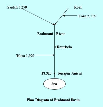
Principal Tributaries of the River
Hirakud Canal System,
Rengali dam,
Kansabahati Irrigation Project, Pitamahal Irrigation Project, Gohira Irrigation Project, Aunali Irrigation Project, Dadaraghati Irrigation Project, Derjang Irrigation Project, Ramiala Irrigation Project.
Water Quality of the Basin
Brahmani, a mighty river during
the monsoon, turns in the summer into more or less a stagnant pool of
water held in deep gorges and pot holes in the river bed. The river becomes incapable of
washing down the pollutants, which are discharged into it from the nearby
industries, towns & villages. Greater part of the