Brief
Description of the Basin
-
Subernarekha, Burahbalang and small east flowing rivers between the Ganga and the Baitarni, are covered under this group.
-
The spatial coverage of this basin extends over an area of 29,196 km2 and lies between east longitudes 85° 10' to 87° 25' and north latitudes 20° 45' to 23° 30'.
-
Lying in the northeast corner of the peninsular India, the region covers relatively large areas in the states of Bihar and Orissa and a somewhat smaller area in West Bengal.
-
The basin is bounded on the north and the west by the Chhotanagpur plateau, on the south by the ridges separating it from the Baitarani basin, and on east by the ridge separating it from the Kasai valley.
-
The basin has a rectangular shape with a maximum length of 305 km in a north-west to south-east direction and a maximum width of 123 km in a north-east to south-west direction.
-
The Subernarekha River basin presents a classic example of conflict among competing uses of water both sectorally and across regions. Fresh water from the river is used by industry as a direct process input and as a disposal agent for the dilution of effluents; by agriculturists for irrigation; and by the household sector for drinking. As long as the resource was abundantly available, it could be treated as a free good. Recently, increasing water scarcity and alarmingly high pollution levels in the Subernarekha River have caused widespread concern in the region major uses of water now find themselves competing for this scarce resource, leading to conflicts amongst various stakeholder groups.
Drainage Area of the Basin
Total Drainage Area of the Basin (in Km2)
Topography
There are two major topographical divisions in the basin, namely (i) the northern plateau and (ii) the coastal plains. The plateau region covers District Purulia of West Bengal and Ranchi and Singhbhum districts of Bihar. Part of the Mayurbhanj district of Orissa lying in the basin is hilly and well forested. The coastal plains lying in the basin cover parts of Balasore district in Orissa and of the Midnapur district of West Bengal. The general slope of the basin is from north-west to south-east. There are four sub-basins of which those of the Subernarekha basin has an elongated shape, while the Burhabalang basin is triangular in shape with the main river as the base and the apex near Kalamgadia village in the Mayurbhanj district.
Water
Potential of the Basin
Tributaries with drainage area in sq.
km.
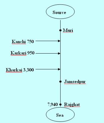
Name of the River
Catchment area in km2
The Subernarekha river basin includes of two reservoirs Chandil and Icha, and two barrages Kharkai and Galudih. On the right bank canal of Galudih barrage (GRBC), there are three small command area reservoirs Haldia, Jambhira, and Baura.
Climate
Average annual rainfall in the Subernarekha basin is on the order of 1,250 mm with the maximum and minimum on record being 1,420 and 1,150 mm, respectively. About 90% of this rainfall is received during the South–West monsoon season, i.e., June to October.