|
Bhakra Beas system is one the most
prestigious and showcase project of
India. The composite Bhakra-Nangal
project consists of the Bhakra dam constructed on
Satluj
River in the State of
Himachal Pradesh and Nangal barrage
constructed on the same river downstream of Bhakra
Dam in the State of Punjab. A distance of around 13 km separates these two
projects.
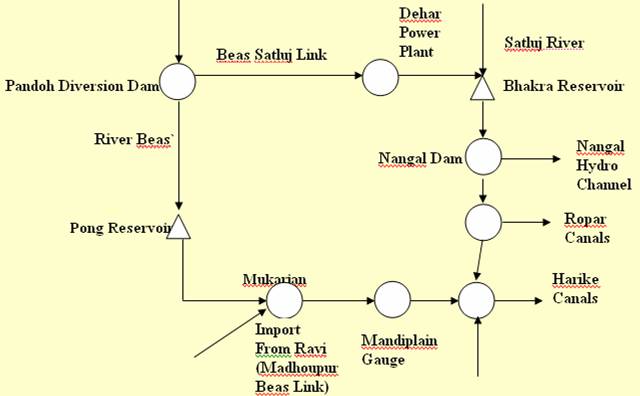
Schematic Diagram of Bhakra
Beas System
Bhakra Dam
The Bhakra dam (bhakra.nic.in) is a concrete gravity dam with a total
height of 225.55 m above the deepest foundation level, completed in 1963. It creates a lake called Gobind
Sagar with total storage capacity of 0.9621 M ha-m at
an elevation 515.11 m and having a surface spread of 16, 868 hectare (41,680
acre). An ogee type of spillway is provided at the center of the dam with its
crest at an elevation 501.4 m. The spillway discharge is controlled by four
15.24 m long radial gates. Facilities for release of water for irrigation and
power production consist of sixteen numbers of 2.64 m horse shoe type river
outlets and 4.572 m diameter steel penstocks, respectively. The river outlets
are arranged in two tiers of eight each in the central spillway section.
Generally water for irrigation is provided through discharges meant for power
generation. However, when the irrigation demand or when the demand at Nangal pond is more than the power releases the river
outlets are operated. The overflow
spillway and river outlets together can take care of around 11,327 cumec of water.
Nangal Barrage diverts the water of
Satluj
River into the Nangal Hydel Channel (NHC) for power generation and irrigation. It
acts as a balancing reservoir with storage about 19.74 MCM to smoothen the
variations in releases from the Bhakra power plants
supplying regulated flow to Nangal Hydel Channel. There
are two powerhouses on the NHC. The
first powerhouse is located at Ganguwal, about 19 km
from Nangal and second is situated at Kotla at a distance of 9.6 km downstream of Gunguwal. A head of
about 28.4 m is available at each of these power houses.
Bist Doab Canal: It takes off from the right bank of River Satluj at Ropar just upstream of Ropar Head Works with full supply discharge of 45.3 cumec. This canal
serves a gross area of 0.25577 million ha.
Beas-Satluj Link
A link between Beas and Satluj rivers could be beneficial in many ways: a) for the
production of hydropower at Dehar Power Plant, b)
augmenting storage in Bhakra reservoir for generation
of power, c) to meet irrigation demands for part of Haryana,
which otherwise could not be commanded from the Beas
at Pong. Also this additional diversion into the Satluj
augments the firm power at Bhakra where two sets of
power plants of 1,050 MW installed capacity are in operation. Beas-Satluj Link (BSL) Project diverts about 4,700 MCM of
water annually from
Beas
River into
Satluj
River.
Beas river water is diverted from Pandoh
dam into the Satluj
River near village Dehar,
upstream of Bhakra reservoir through a 38 km long
water conductor system. The head due to an elevation difference of more than
335 m is utilized to generate 990 MW power.
Water of Beas river at Pandoh dam is carried
through a tunnel up to Baggi, through an open hydel channel up to Sundarnagar,
and through a tunnel from Sundarnagar to Slapper. In between the hydel
channel and Sundarnagar-Slapper tunnel, a Balancing
Reservoir (BR) has been constructed at Sundarnagar
with limited storage capacity to ensure regulated water supply to meet the
fluctuating and peaking load requirement for power generation at Dehar Power House.
The Pandoh-Baggi
Tunnel (PBT), 7.62 m diameter and 13.1 km length carries 255 cumec water and outfalls into concrete lined hydel channel. Water flows through this 1.8 km long open
channel into Sundarnagar Balancing Reservoirs (BR).
The Sundarnagar BR has 3.7 MCM live storage capacity
and takes care of fluctuating water demand at the Dehar
power House. Sundarnagar Slapper
tunnel (8.53 m dia, 12.38 km long) terminates into
surge shaft. The tunnel carries 404 cumec of water
for running six generating units of Dehar Power Plant
(DPP) and flows into Satluj
River. The DPP located on the right
bank of river Satluj produces 990 MW power at its
full capacity.
Beas, Satluj and other Himalayan
rivers are known for their high silt content. The tributaries of river Beas, viz. Tirthan, Parboti and Sarvori meet the
Beas upstream of Pandoh dam.
Silt laden Beas river water from Pandoh dam
flows through tunnel and hydel channel into the
BR. The large quantity of silt carried by the
Beas settles in the BR at Sundarnagar
reducing its holding capacity. Hence, silt disposal from BR is carried out
through dredging. Silt dredger with a capacity of 500-800 m3 of
solids/hr with 15% to 20% of silt by volume is installed in the
BR. The dredged slurry is discharged into the Sukheti khad flowing adjacent to
the BR.
The Sukheti
Khad confluences
Beas River near Mandi
town after flowing a distance of 21 km through a relatively flat terrain.
Silt load in the river system
Out of total catchment of 5,278 sq. km of the Beas, 784 sq. km has been identified as a high silt
yielding area, specifically in the sub-watershed of Parvati,
Bhunter and Larji. It was
anticipated that a total silt load of 407 ha-m would
annually reach Pandoh dam and would fill the dead
storage of the dam in 27 years. However, silt in Pandoh
dam was filled up to the spillway crest in a period of nine years after
commissioning of the project. Operational guidelines for post delta stage were
prepared by BBMB for bed load passes. According to these guidelines, flushing
and dredging operations were started in 1986 to restrict the entry of sediment
into PBT. It was also anticipated that on an average 215 ha-m of suspended load
would enter the water conductor system of BSL and settle in BR, which has a
live storage of 369 ha-m. Out of 162 ha-m of silt
entering in the BR, about 80 ha-m of silt settles in it annually.
Beas Unit –Pandoh Dam:
The Beas-Satluj link
scheme consists of a 76.2 m high rockfill diversion
dam at Pondoh on Beas
River in Mandi district (HP). The
Pandoh dam was constructed in 1977 at Pandoh, 21 km upstream of Mandi
town on Mandi-Kulu road in Himachal
Pradesh. The reservoir has a live storage of 18.56 MCM. The conveyance system
comprises 13.2 km long, 7.62 m diameter tunnel from Pondoh
to Baggi and 11.4 km long hydel
channel from Baggi to Sundernagar
with a maximum capacity of 212.5 cumec. From the tail
of the canal, water is led to the Satluj power plant
near Dehar. There are six turbines to generate power,
each with an installed capacity of 165 MW.
Beas Project-II
Pong Dam: Pong is a multipurpose
earth & rockfill dam on
Beas
River, 40 km from Mukerian, Mukerian District, Himachal
Pradesh. It is located in the Himalayan foot-hills downstream of Pandoh dam. It has a central impervious core with sand and
gravel shell zones on either side. The dam is 132.6 meter high from the deepest
foundation level and about 100.6 meter high above the river bed. The catchment area at the dam is 12,560 km2. The
height and length of the dam is 133 m and 1,951 m respectively. The reservoir has a gross storage capacity of
8,570 MCM and live storage of 7290 MCM at FRL 426.72 m and the MDDL is at 384
m. At FRL, the water spread area covers about 260 sq. km. Pong power house has
6 units of 60 MW each, with mean annual inflow of 15,338 MCM. It has a firm
power of 156 MW. BBMB commissioned the project in 1978-83.
When the
water level reaches 426.7 m the spillway radial gates would be raised. From irrigation and power generation
considerations, the minimum level of permissible water level has been fixed at
an elevation of 384 m. Between the FRL at 426.7 m and the dead storage level of
384 m a capacity of 0.729 M ha-m for controlled irrigation and power generation
is available. An overflow spillway with
six bays of 14.4 m (47.5 ft each has been provided on the left abutment of the
dam with the crest at an elevation of 416 m. The discharge over the spillway is
controlled by six 14.5 m wide and 12.34 m high radial gates with a discharging
facility of 12,375 cumec at the highest flood level
of 433.12 m.
There are several hydropower
plants under Bhakra System in
Indus
basin.
The installed capacity of
hydropower plants under Bhakra system
|
Name of the hydropower
plant
|
Installed Capacity
|
(MW)
|
|
Bhakra (Right
Bank)
|
3x132 + 2x157
|
710
|
|
Bhakra (Left
Bank)
|
5x10⁸
|
540
|
|
Ganguwal
|
2x24.2 + 1x29.25
|
77.65
|
|
Kotla
|
2x24.2 + 1x29.25
|
77.65
|
|
|
6x165
|
990
|
|
Pong
|
6x60
|
360
|
|
|
Total
|
2,755.30
|
Sharing of Benefits
a) Distribution of water
-
Sutlej water: As per the Bhakra Nangal Agreement of 1959, the share of
Punjab, Haryana
and Rajasthan is 57.88%, 32.31% and 9.81% respectively.
-
Ravi Beas water: According
to the agreement of 1981 and the distribution approved by BBMB in 1982, the
surplus Ravi Beas water
(after taking out pre-partition utilization) is distributed among
Punjab, Haryana
and Rajasthan in the ratio of 30%, 21% and 49%, respectively.
Delhi and Jammu & Kashmir
have been given fixed shares of 0.2 MAF and 0.65 MAF as per 1981 agreement. No
water has been allocated either from Bhakra Nangal or from Beas Project to
HP. The Board has been approving the proposals from HP regarding supply of
water for irrigation and drinking water purposes out of the Bhakra
Nangal and
Beas projects.
b) Distribution of Power
-
Bhakra Complex: 15.22% of available energy less the requirement of Common
Pool Consumers and transmission losses is distributed to Rajasthan. The
remaining 84.78% to Punjab, Haryana, New H.P. and UT
of Chandigarh in the proportion 54.5%, 39.5%, 2.5%
and 3.5% respectively.
-
Dehar Power Plant: Available
power less 15 MW to HP allocated by Government of India, 4% transmission losses
and project supply at Sundernagar, Slapper and Pandoh is distributed
to Punjab, Haryana and
Rajasthan in the ratio 48%, 32% and 20%, respectively.
-
Pong
Power Plant: Available power less project supplies at Talwara
and 4% transmission losses is shared by
Punjab, Haryana
and Rajasthan in the same ratio as the sharing of cost, viz., 24.9%, 16.6% and
58.5%.
Operation of Bhakra and Pong Reservoirs
Indira
Gandhi Nahar Project (IGNP)
Indira Gandhi Nahar Project is a
standing example of how large inter-basin transfers have brought about all round
socio-economic growth with overall improvement in the ecology and environment
of the region. Under the Indus Water Treaty, the waters of three eastern rivers
viz. Satluj,
Beas and
Ravi were allocated to
India. As the land to be benefited in
India lies mostly to the east and south of these rivers,
the three rivers had to be interlinked and the water conveyed to canal systems
for serving vast agricultural tracts in Western India. The main storage on Satluj
is at Bhakra while that on Beas is at Pong. Bhakra system
provides irrigation to 26.3 lakh ha of new area
besides stabilization of existing irrigation on 9 lakh
ha. The Beas-Satluj link is 37.25 km long, of which
25.45 km passes through a tunnel under difficult rock formations. The capacity
of the tunnel is 254.70 cumec. Another dam on Ravi namely, Ranjit Sagar dam will provide additional water to Beas and also generate a large amount of power.
Subsequently, it was decided to provide 9.36 BCM of water to
Rajasthan
Canal (Indira Gandhi Nahar) for irrigating the areas of Thar Desert.
Transfer of surplus
waters of Ravi, Beas and Satluj to Rajasthan right up to Jaisalmer
and Barmer through Indira
Gandhi Nahar Pariyojana has
eliminated drought conditions, provided power benefits and transformed desert
waste land into an agriculturally productive area by bringing irrigation and
vegetation to about 2 M-ha area. Contribution in agricultural production due to
implementation of the project is worth Rs. 1,750 crore annually. Canal water is also being used to meet domestic
needs. The project has dramatically changed the living standard and
socio-economic conditions of the people in the region.
The post independence era of
the country has witnessed rapid strides in creation of irrigation potential,
resulting in substantial increase of agricultural production. The IGNP (formerly known as The Rajasthan Canal Project) with a command area
of 15.43 lakh hectare is the largest irrigation and
drinking water project to cater five districts in north-western Rajasthan. The main canal gets water from the
Satluj
River in
Punjab through a feeder canal which takes off from Harike Barrage, constructed at a point down stream of its
influence of Beas and
Satluj
Rivers.
The entire project comprises
of the main Indira
Gandhi
Canal, nine branches, three lifts, and 21 district
distributaries with a length of 7,150 km. The project has been divided in two
stages. Under the first phase, Rajasthan
feeder, the main canal up to 195 km, the Suratgarh
low level, and Namshera branches were completed.
Under the second stage the construction of remaining portion of the main canal
from Chhatargarh to Mohangarh
has been completed. The irrigation potential from the IGNP project is assessed
as 13.87 lakh ha.
The IGNP is a gigantic
canal project to carry 524 cumec
water from the Harike Barrage in a 204 km long
feeder canal in Punjab, to the vast
Great Indian Desert, known as the
Thar
Desert, in Western Rajasthan. The canal network is spread in an area of about 60
km wide and 1,000 km long belt. It consists of 204 km of feeder, 450 km main
canal, 8000 km of distribution networks and several thousand km of lined water
courses, to spread over a gross command area of 2.5 Mha
and provide irrigation to a culturable command of
1.55 Mha.
The salient features of the IGNP are:
-
It will provide additional irrigation in 964,000
hectares,
-
Will deliver drinking water for 14 million
humans, besides a large cattle population,
-
Will help afforesation
in an area of 362,000 hectares,
-
Would provide fodder for 5.2 million units of
cows or equivalent animals,
-
Is expected to provide direct employment to
500,000 persons on regular basis, and
-
Will enables exploitation of mineral resources
and industrialization.
The project was conceived
by the great Indian civil engineer, Kanwar Sain, around the year 1940 and construction was started in
the year 1958. Since then, the project has gone under considerable
modifications and revisions. It is still (year 2006) under construction near
tail areas. Planning, design and construction of canal system is managed by a
high powered Canal Board with many advisory and technical committees.
The main canal is a contour
canal with distribution network and irrigation on the right side only. Few lift
schemes are provided on the left side. Although the main canal was initially
conceived as unlined, design was subsequently modified and it was constructed
as a lined canal as it passes through sandy desert soils. High cuttings of
about 20 m above bed level as well as heavy bed filling of more than 4 m are
encountered in the course of the canal.
No construction
materials except the desert sand are available along the canal or even within
100 km. There are no rivers or stone hillocks nearby. However, there are some
stone hillocks near Ratangarh at a distance of 200 to
300 km from main canal and in tail areas after 450 km of canal (near Mahangarh) at a distance of about 50 km from the tail. Even
the coarse sand (locally known as Bajri) required for
cement mortar is available at a distance of 200 to 300 km away from canal in
deep quarries of Shivbari (Bikaner) and Bap (Phalodi). However, clay soil for manufacture of
tiles/bricks is available in small pockets in depression in between sand dunes,
at distances varying from 5 to 100 km.
The geology of the area is
completely concealed under the thick blanket of dunal
sand and alluvium; no rock exposures are seen on the surface. The lithology of
deep bore holes, dug cum bore hole and piezometers in
the area reveal that stratigraphical unit in the area
ranges in age from alluvium of quaternary group consolidated sedimentaries of paleozoic
group.
In the head reaches,
the depth of the canal is limited to 6.5 m for stability of sandy soils,
operational problems and easiness in construction. It gradually decreases in
tail. Internal side slopes of 1:2 (V:H) were considered safe for sandy soils
and provided for depth from 6.5 m to 5 m, throughout the entire 450 km length
of the main canal. Bed slope has also been restricted to 1 in 12,000, because
of long length of canal and to have sufficient command. Even with this flat
slope, the drop in water level is 54 m from head to tail. It is uniform from
head to tail in 450 km length. Thus velocities are also very much limited in
the entire length from 1.5 m/s to 1.2 m/s. Bed width varies practically from 11
times the depth at head to 2 times the depth at tail. Single tile lining in bed
and double tile lining on sides has been adopted. Burnt clay tile lining is
provided up to 365 km and thereafter P.C.C. block lining is adopted till the
end.
Nathpa Jhakri Hydroelectric Project
The 1500 MW Nathpa Jhakri Hydropower Project
(NJHP) is a prestigious project commissioned by Satluj
Jal Vidyut Nigam Limited (SJVN). SJVN (Formerly Nathpa
Jhakri Power Corporation Limited) was incorporated in
1988 as a joint venture of the Govt. of India and the Govt. of Himachal Pradesh. Work on NJHP began in 1993. The project
includes a 60.5 m high dam and underground desilting
complex. While the dam is located at Nathpa village
in Kinnaur District, the power house is located on
the left bank of
Satluj
River at Jhakri in Shimla District. NJHP has many unique features. It has one
of the largest underground desilting complexes of the
world, one of the deepest surge shafts of the world, and an underground power
house with large a cavern of 222m X 20m X 49m, housing 6 Francis turbines
of 250 MW each. NJHP will generate 6700 Million Units of electrical energy
in a 90% dependable year. The first unit of the project was commissioned in October
2003. SJVN is also associated with many other projects besides NJHP. Details
about Satluj Jal Vidyut Nigam Limited are
available at sjvn.nic.in.
Flash floods in
August 2000 led to extensive loss of time and money to the project, and caused
severe destruction to the dam and power house.
Other Projects
Anandpur Sahib
Anandpur Sahib hydropower project is
located on Anandpur
Sahib
Canal that takes off from Nangal
barrage on Satluj
River, 8 km from Anandpur Sahib
in Ropar District, Punjab.
Two hydropower houses namely Anandpur Sahib I and Anandpur Sahib II have been constructed under this scheme.
Both the powerhouses have 2 units of 33.5 MW each with a total installed
capacity of 134 MW. It has a firm power of 105 MW. Punjab State Electricity
Board (PSEB) commissioned the project in 1985.
Baira Siul Project
Baira hydropower project
is an earth core and rockfill dam on
Baira
River supplemented by Bhaledh and
Siul
Rivers, tributaries of
Ravi
River in
Indus basin. The dam is located in Chamba
District, Himachal Pradesh near Pathankot.
The catchment area at the dam is 1,038 sq. km out of
which 660 sq. km lies in Baira river basin and the
rest lies in Bhaledh
River
basin. The
height and the length of the dam are 53 m and 160 m respectively. The reservoir
has a live storage capacity of 1,270 MCM at FRL 1,122.15 m and the MDDL of the
reservoir is at 1,113 m. Baira surface power house has 3 units of 60 MW each, with
mean annual inflow of 1,060 MCM. It has a firm power of 39 MW and the annual generation is 750 million units in 90% dependable year. NHPC
commissioned the project in 1981 at a cost of Rs. 142.5 crore.
Baspa II
Baspa II hydropower project has been
constructed on a gated barrage on Baspa
River, a tributary of
Satluj
River in
Indus basin. The project is located 210 km from Shimla in Kinnaur District, Himachal Pradesh. The catchment
area at the dam is 969 sq. km. The barrage has a live storage capacity of 75 ha-m at FRL 2,531.50 m and the minimum pond level is
at 2,527.50 m. The power house has 3 units of 100 MW each, with annual inflow
of 99,175 ha-m and 146,737 ha-m on 90% and 50%
dependable year respectively. The
project was commissioned in 2003.
Bassi Project
Bassi power project is
located in Jogindernagar district in Himachal Pradesh. The project utilizes tail waters of Shanan reservoir located in the upstream of Bassi on Uhi
River, tributary of
Beas
River. Bassi power house has 4
units of 15 MW each. It has a firm power of 16 MW. HPSEB commissioned the project in 1970-81.
Chamera I
Chamera I is a
major project consisting of a concrete arch gravity dam on
Ravi
River, 25 km from Dalhousie and 80 km from Pathankot in Chamba District, Himachal Pradesh. The catchment
area at the dam is 472.5 sq. km. The height and the length of the dam are 140 m
and 295 m respectively. The reservoir has a live storage capacity of 110 MCM
and mean annual inflow of 1,273 BCM. Its FRL and MDDL are 760 m and 747 m. Chamera I underground power
house has 3 units of 180 MW each. It has a firm power of 160 MW and in a 90% dependable year, the annual generation is 1,664 million units. NHPC
commissioned the project in 1994 at a cost of Rs. 2,114 crore.
Chamera power station – II
It is located near Pathankot,
in Distt. Chamba, Himachal Pradesh. It has a 39 m high, 118.50 m long concrete
gravity dam and an underground power house containing 3 units of 100 MW each.
In a 90% dependable year, the annual generation is 1,500 MU. This project was
completed by NHPC in 2004 at an estimated cost of Rs.1,930
crore.
Lower
Jhelum
Lower
Jhelum dam has been constructed on
Jhelum
River near Warikhah in Baramulla District, Jammu & Kashmir.
Lower Jhelum power house has 3 units of 35 MW each. It has a firm power of 62 MW. J&KPDC
commissioned the project in 1978-79.
Malana
Malana is a concrete gravity dam completed in 2001 on
Malana
River, a tributary of Parbati
River of Beas basin. The dam is located 20 km from Bhuntar in Kulu District, Himachal Pradesh. The catchment
area at the dam is 4,725 sq. km. The height and the length of the dam are 18 m
and 305 m respectively. The reservoir has a live storage capacity of 0.249 MCM
at FRL 1,893 m; the MDDL has been fixed at 1879 m. Malana
power house has 2 units of 43 MW each, producing a firm power of 12 MW. It has
a mean annual inflow of 403 MCM.
Mukerian
Mukerian is a hydropower project, located on
Shah
Nahar
Canal diverted from
Beas
River, in Hoshiarpur District,
Punjab.
A barrage namely Shah Nahar barrage has been
constructed 5 km down stream of Pong dam in Hoshiarpur
District, Punjab. Four hydropower projects namely Mukerian
I, Mukerian II, Mukerian
III, and Mukerian IV have been constructed under this
scheme. The Shah Nahar barrage has a pond level of
330.7 m. The length of the barrage is 562 m. The barrage has been constructed
for a design flood of 11,073 m3/s. Two
powerhouses have 3 units of 15 MW and other two powerhouses have 3 units of
19.5 MW each. Thus the Mukerian power house has a
firm power of 137 MW. Punjab State Electricity Board (PSEB) commissioned the
project in 1983-89.
Sanjay
Bhaba
Sanjay Bhabha hydropower
project consists of a gated weir, namely Bhabha weir,
located on Bhabha Khad,
tributary of Satluj
River, 190 km from Shimla in Kinnaur District, Himachal
Pradesh. The catchment area at the weir is 280 sq.
km. The pond has a storage capacity of 0.304 MCM at maximum water level 2425.20
m. The power house has 3 units of 40 MW each, with mean annual inflow of 480
MCM. It has a firm power of 33 MW. HPSEB
commissioned the project in 1989.
Salal Project
Salal I is a 113 m high,
450 m long rockfill concrete dam on Chenab River, 90 km from Jammu in Udhampur
District, Jammu & Kashmir. The catchment area at
the dam is 21,500 sq. km. The height and the length of the dam are 113m and 630
m respectively. The FRL of the dam is at 487.68 m. Salal
sub-surface power house has 3 units of 115 MW each. With mean annual inflow of
21,000 MCM, its annual generation is 2,038
MU. It has a firm power of 227 MW. NTPC commissioned the project in 1987. At
1987 price level, the project cost was Rs. 6,212.1 million.
Salal Power Station – II
It has a capacity of 345 MW (3 x
115 MW) and annual generation of 1,063
million units. Its 1st unit was commissioned in 1993, 2nd
unit in 1994, and the 3rd unit in 1995.
Shanan Project
Shanan dam has been
constructed on
Uhi
River and its tributary
Lambadug
River, tributaries of
Beas
River in
Indus basin. It is located 4 km from Jogindernagar
in Kangra District, Himachal
Pradesh. The catchment area at the dam is 381 sq. km.
Shanan power house has 4 units of 15 MW each including
one extra unit of 50 MW.
Thein Dam (Ranjit Sagar)
Ranjit Sagar Hydropower house is
located at Thein earth and rockfill
dam on Ravi
River, 24 km from Madhopur
barrage, in Gurdaspur District,
Punjab.
The reservoir behind the Thein dam is known as Ranjit Sagar reservoir. The catchment area at the dam is 6,086 km2. The
height and length of the dam is 160 m and 617 m respectively. The reservoir has
a live storage capacity of 2,344 MCM. The power house has 4 units of 150 MW
each. It has a firm power of 129 MW. Punjab State Electricity Board (PSEB)
commissioned the project in 2000.
UBDC Project
Upper
Bari
Doab
Canal (UBDC) is a hydropower project, located on Madhopur barrage, on
Upper
Bari
Doab
Canal diverted from
Ravi
River, 12 km from Pathankot in Gurdaspur District, Punjab.
The hydropower complex is a mixture of three power projects, namely UBDC I,
UBDC II, and UBDC III. The Madhopur barrage is 774 m
long and has a normal pond level of 348.5 m. The catchment
area at the project is 6,086 km2. The barrage has been constructed
for a design flood of 17,750 m3/s. All the
three powerhouses have 1 unit of 15 MW and 1 unit of 15.45 MW each with a total
installed capacity of 91.35 MW. It has a firm power of 55 MW with mean annual
inflow of 8,609 MCM. Punjab State Electricity Board (PSEB) commissioned the
project in 1971-91.
Upper Sindh II
Upper Sindh II dam has been constructed on Sindh
Nallah and Wangath Nallah tributaries of Jhelum
River. It is located 40 km from
Srinagar in Srinagar Kangan District, Jammu & Kashmir. The catchment area at the dam is 927 sq. km out of which 697
sq. km lies in Sindh basin and the rest 230 sq. km in
Wangath basin. The tail waters of
Upper Sindh I are diverted into Upper Sindh II for power generation in the project. Upper Sindh II power house has 3 units of 35 MW each. JKPDC
commissioned the project in 2000-02.
Uri
Project
Uri is a 20m high 93.5 m long barrage, located on
Jhelum
River, 8 km from Baramulla in
Kashmir North District, Jammu & Kashmir. The catchment
area at the dam is 12,570 sq. km. The reservoir has a live storage capacity of
0.36 MCM and mean annual inflow of 8,400 MCM. The FRL of the reservoir is 1,491
m. Uri underground power house has 4 units of
120 MW each, It has a firm power of 213 MW and annual generation of 2,663 million units in a 90% dependable year. NTPC
commissioned the project in 1997 at a cost of Rs. 3,300 crore.
Small Hydro Projects
Licences have
been given to set up 4 x 5 MW small hydroelectric power projects in Kangra District of Himachal
Pradesh. The projects are: 5 MW Baner III, 5 MW IKU
II, 5 MW Drinidhar, and 5 MW Upper Khaul. Another private company has won the bid for the 70
MW Budhil Project in Chamba
district. The power plant will have two units of 35 MW each and will generate
313.33 million units of power per annum.
PROJECTS UNDER
CONSTRUCTION
In addition to the above several other projects under
construction or consideration.
Baglihar Hydro-Electric Project
The
hydropower potential from the four major river basins in the state of Jammu and
Kashmir, namely, Chenab, Jhelum,
Indus, and Ravi has been estimated to
be in the range of 11,000 MW. The
Chenab basin by itself has the largest
potential, with an estimated capacity of 8,000 MW (at 60% load factor). Eight
hydropower projects with a total capacity of 5,320 MW have already been
identified along its track in
Jammu and Kashmir
State. However, only about 10% of this huge
renewable source of energy on
Chenab has been exploited up to now. Baglihar is one of such projects with ultimate installed
capacity of 900 MW to be developed in two stages of 450 MW each. It is located
across
Chenab
River in Doda
District.
Pakistan has raised objections against this
project under the Indus Water Treaty.
Bursar Project
Investigations are
in progress for the
1020 MW (4 x 255
MW) project consisting of a
252m
high rockfill
dam and an underground power
house near
Hanzal Village
(near
Kishtwar)
in Doda District of Jammu & Kashmir.
Annual
generation is expected to be
2,018 MU (in a 90% dependable year) at an estimated
cost of
Rs.4,378
crore.
Chamera Stage -
III Project
It is being constructed in Chamba Distt. in Himachal Pradesh. A 68 m high concrete gravity dam on
Ravi
River is being constructed along with an
underground power house consisting of 3 units of 77 MW each (total 231
MW). Completion is scheduled by August
2010 at estimated cost of Rs.1,406 crore.
Chutak Project (Proposed)
This project is
located near
Minji
Village in Kargil
District of Jammu & Kashmir. A 47.5
m long diversion barrage with an underground power house having 4 units of 11 MW
each are proposed.
Dulhasti Project
It involves a 65 m high, 186 m long concrete gravity dam, being
constructed in Doda District in J & K. An
underground power house containing 3 units of 130 MW each (=390 MW) will generation 1,928 MU annually at an estimated cost of Rs.
3,560 crore when it is complete (expected date is end
of 2006).
Kishanganga Project
This is a proposed run-of-the-river hydropower
project on Jhelum
River. It
will be
located near
Kralpore
Village (near Bandipore) in Baramulla District of Jammu & Kashmir. Its underground
power house will have an
installed power production capacity of 330 MW yielding an annual generation of 1,350 MU in a 90%
dependable year. Like the Baglihar Project, construction
of this project has also been opposed by
Pakistan claiming that the diversion tunnel of this project
will cause reduction in flow of
Neelam
River which will be detrimental to
Pakistan’s interests.
Kol Dam
This project is being constructed by the National Thermal
Power Corporation (NTPC) across Satluj
River, 4 km upstream of Dehar
Power Plant in Bilaspur District. Kol
Dam will be a 163m high rock and gravel fill dam with clay core. Its crest
level will be at 648 m. Kol reservoir will have MDDL
at 636 m, FRL at 642 m, and MWL at 646 m. Four units, each of 200 MW capacity will yield total installed capacity of 800 MW. The
estimated annual generation in a 90 % dependable year will be 3054 GWHr and the estimated cost of the project is Rs. 6,300 crore. Work on the
project began in the year 2000.
Nimoo Bazgo Project
It is proposed
near Alchi village in Leh
District of Jammu & Kashmir. A 57 m high 247.9 m long concrete gravity dam is proposed to be constructed with a
surface power house. The project will have
installed capacity of 45 MW (3 X 15 MW) yielding an annual generation of 239.33 MU in a 90% dependable year.
Pakal Dul Project
It is located
near Village Pakal (near Kishtwar) in Doda District of Jammu & Kashmir. It will have a 167 m
high concrete face rockfill dam and an underground power house with capacity of 1,000 MW (4X 250 MW),
giving an annual generation of 3,387
MU (in a 90% dependable year). The project is likely to cost Rs.
5,577 crore. The DPR for the project has been
completed.
Parbati Stage – II
Project
It is being constructed near
Kiratpur in Distt. Kullu, Himachal Pradesh. The
project will have a 85 m high concrete gravity dam and
a surface power house containing 4 Pelton Turbine
Generating units of 200 MW each. These turbines will generate 3,108.66 MU of energy annually (90% dependable
year). The estimated cost of the
project is Rs. 3,920 crore
and it is likely to be commissioned by September 2009.
Parbati Stage – III Project
This project being constructed on
Sainj
River in Kullu
district, Himachal Pradesh consists of a 43 m high rockfill dam with a 34.5 m orifice type spillway. The
underground powerhouse will have 4 units of 130 MW each. It will produce 1977
million units of power in a 90% dependable year. The latest estimated cost of the project is Rs.
2,305 crore.
Work has commenced and is expected to be completed by November, 2010.
Sewa Project
The Sewa
project is being constructed on Sewa
River, a tributary of
Ravi
River, in Basholi tehsil of Kathua
River in
Jammu and Kashmir. Here, a hydropower project, known as Sewa stage-II is under construction. The project envisages
53 m high concrete gravity dam, a tunnel and three units of 40 MW each in the
under-ground powerhouse. The estimated cost of the project is Rs. 665.46 crores. The project is
likely to be completed by August 2007 (The Times of India newspaper, August
11, 2004). The
installed capacity of power plant will be 120 MW and it will generate 533.52 MU
of energy annually.
Sewa Stage – II Project
Is located near
Pathankot on Sewa
River (a tributary of Ravi) in Kathua
District,
J&K
State. The project consists of a 53 m high
concrete gravity dam. Is power house will be equipped with 3 x 40 MW
vertical Pelton turbine units with rated net head of
560 m. Annual generation is expected to
be 534 MU (90% dependable year). The estimated cost of the project is Rs. 665 crore and it is likely to be completed by the end of 2007.
Uri Stage - II
Project
This project is located in
Uri Tehsil of Baramulla
district in Jammu & Kashmir. The project consists of a concrete gravity
dam, 52 m high, 173.2 m long with spillway consisting of 4 bays of 9.0 m each.
An underground power house of 132 m length, 15 m width, and 41 m height is
being constructed to accommodate 4 units of 60 MW capacity
each. Annual energy generation from the
plant to the tune of 1,124 MU (90% dependable year) is expected. This
project is scheduled for completion by
Nov. 2009 at an estimated cost of Rs.1,725 crore.
|