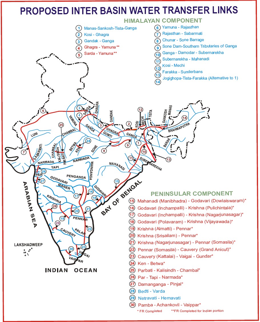
Himalayan Rivers Development Component
The Himalayan component envisages construction of storage reservoirs on the main Ganga and Brahmaputra Rivers and their principal tributaries in India and Nepal so as to conserve monsoon flows for irrigation and hydro-power generation, besides flood control. Links will transfer surplus flows of the Kosi, Gandak and Ghagra to the west. In addition, the Brahmaputra-Ganga Link will augment dry-weather flow of the Ganga. Surplus flows that will become available on account of inter-linking of the Ganga and the Yamuna are proposed to be transferred to the drought prone areas of Haryana, Rajasthan and Gujarat. With this proposal about 14 Mha-m of additional water would be available from these river systems for irrigating an estimated 22 M-ha in the Ganga-Brahmaputra basin apart from Haryana, Punjab, Rajasthan and Gujarat. It would also provide 1120 cumec to Calcutta Port and would provide navigation facility across the country. It will also provide flood moderation in the Ganga-Brahmaputra system. The Himalayan component will benefit not only India but also Nepal and Bangladesh. Fourteen links are proposed in the Himalayan component.
Proposed Fourteen Links in the Himalayan Component
|
1 |
Kosi-Mechi |
2 |
Kosi-Ghagra |
|
3 |
Gandak-Ganga |
4 |
Ghagra-Yamuna |
|
5 |
Sarda-Yamuna |
6 |
Yamuna-Rajasthan |
|
7 |
Rajasthan-Sabarmati |
8 |
Chunar-Sone Barrage |
|
9 |
Sone Dam-South Tributaries of Ganga |
10 |
Brahmaputra-Ganga (MSTG) |
|
11 |
Brahmaputra-Ganga (JTF)(ALT) |
12 |
Farakka-Sunderbans |
|
13 |
Ganga-Damodar-Subernarekha |
14 |
Subernarekha-Mahanadi |
In view of the ongoing dispute on the sharing of the Ganga water with Bangladesh, little details of this component are available. In broader terms, storages and links of the Himalayan component are of mammoth size. Due to size, topography and other reasons, construction and environmental problems might be enormous. Further, there appears to be some anomalies in the planning of this component. Since no additional storages are proposed on the Ganga and the Yamuna, their monsoon flows will continue to go to the Bay of Bengal while huge funds are to be spent to transfer water of Kosi, Ghagra, Gandak and Sarda to the West. The Satluj Yamuna link (which has not been made operational due to inter-state dispute) would transfer water from west to east, the proposed Sarda-Yamuna link towards east will flow in the opposite direction. Similarly, the Narmada canal transfers Narmada waters across Sabarmati towards North-West, the proposed Rajasthan-Sabarmati link will flow in the opposite direction towards South-east.
Interlinking of the Brahmaputra with the Ganga, the Subernarekha and the Mahanadi is proposed to transfer waters of the Brahmaputra to benefit areas in Assam, West Bengal, Bihar, Jharkhand and Orissa. The Manas-Sankosh-Teesta-Ganga link is an important link in this component. This link envisages diversion of surplus water from Manas and Sankosh rivers in the Brahmaputra basin to augment flows of the Ganga upstream of Farakka. A link to the Peninsular component through Subernarekha and Mahanadi is also envisaged. For this link high dams are proposed at Manas and Sankosh with storage capacities of 8.75 BCM and 4.93 BCM, respectively (Singh 2002). A substantial part of the cost of these dams will be allocated to hydropower generation. The 114 km long link canal between Manas and Sankosh will have a discharge capacity of 3,725 m3/s. Beyond Sankosh and up to the Teesta barrage, the link canal is 137 km long with a capacity of 1,092 m3/s. Clearly, this will be a huge canal which will cross major drainages. The MSTG link passes through the narrow chicken neck in West Bengal (north of Bangladesh) and may have security aspects.
The Ghagra-Yamuna link project is an inter-dependent link under the Himalayan Component of NPP. A study reveals that the Ghagra River (known as Karnali in Nepal) at the proposed the Chisapani dam site has surplus water. It is proposed that the existing requirement of water for the Sarda Sahayak Pariyojna, Saryu Nahar Pariyojna and various pump canals would be met from the proposed Gandak - Ganga link project and the water saved thereby could be diverted from the proposed Chisapani reservoir through the Ghagra - Yamuna link canal. The height of proposed dam is 175 m. A regulating dam downstream of the Chisapani dam is proposed with a full reservoir level of 200 m and a minimum drawdown level 193 m. The link canal shall join Yamuna River in Etawah district of Uttar Pradesh. The total length of the link canal would be about 417 km with its depth varying from 8 m in the head reach to 5 m in the tail reach and the width varying from 85.5 m in the head reach to 18 m towards the tail end.
This is a continuous link having a combination of three links, viz., the Sarda-Yamuna link, the Yamuna-Rajasthan link, and the Rajasthan-Sabarmati link. This link canal is planned to divert 17,906 MCM (14.52 MAF) water of Himalayan rivers. Its length will be 1,835 km out of which 75 km will be in Gujarat State. A total of 4 states, Uttar Pradesh, Haryana, Rajasthan and Gujarat, are to be benefited by this link. About 1,627 MCM (1.32 MAF) water has been allocated to North Gujarat which is only 9% of the total divertible water at the canal head. A total 7.38 lakh ha area is to be irrigated by the Rajasthan-Sabarmati link, out of which 5.35 lakh ha in Rajasthan and 2.03 lakh ha in Gujarat.
The Yamuna-Rajasthan link proposal is an extension of the proposed Sarda–Yamuna Link beyond the Yamuna to provide irrigation to the drought prone areas of Haryana and Rajasthan. It envisages diversion of 8,657 Mm3 of water from the Sarda basin at Purnagiri. The Yamuna - Rajasthan link is to take off from the right bank of proposed Yamuna barrage and passes through the Karnal, Sonipat, Jind, Hisar and Bhiwani districts of Haryana and Churu, Hanumangarh, Ganganagar, Bikaner, Jodhpur and Jaisalmer districts of Rajasthan and ends on the Jaisalmer-Hamira-Shri Mohangarh Road at a distance of 4.5 km from village Kanod towards Jaisalmer. The length of the link canal is 786 km, out of which 196 km lies in Haryana and the rest 590 km in Rajasthan. The design discharge at head and tail are 572 cumec and 344 cumec, respectively. The longitudinal slope of the canal is 1:20,000. The full supply depth and bed width of the canal at head are 7 m and 53 m, respectively. The Yamuna - Rajasthan link will provide an annual irrigation of 244,200 ha in the districts of Ganganagar, Bikaner, Jodhpur and Jaisalmer of Rajasthan.
The Rajasthan-Sabarmati link canal is an extension of the proposed Yamuna–Rajasthan Link. The link envisages a transfer of 5,924 Mm3 water available at the tail end of the Yamuna-Rajasthan link for drought prone areas of Rajasthan and Gujarat. The length of the canal is about 725 km out of which 650 km lies in Rajasthan and the rest 75 km in Gujarat. The design discharge at the head and the tail are 344 cumec and 60 cumec, respectively. The full supply depth and bed width of the canal at its head are 6 m and 39 m, respectively. The link canal on its way will cross the Luni River & its tributaries and the Banas River.
The Rajasthan-Sabarmati link will provide an annual irrigation of 535,000 ha in the districts of Jaisalmer, Barmer and Jalor of Rajasthan. The total annual irrigation thus envisaged in Rajasthan State through the above two interbasin water transfer links works out to be 779,200 ha.
Further, interlinking the Gandak, the Ghagra, the Sarda and the Yamuna, all tributaries of the Ganga, on to Rajasthan and the Sabarmati aims at transferring the waters of Gandak and Ghagra Rivers to benefit areas in Uttar Pradesh, Uttaranchal, Haryana, Rajasthan, Gujarat, Bihar and Jharkhand. Other important links proposed in the Himalayan component are the Kosi-Ghagra, Gandak-Ganga, Ghagra-Yamuna and Sarda-Yamuna links to supplement the supplies of the Ganga and the Yamuna and for further transfer of water towards the west to Rajasthan and Gujarat. A large canal parallel and to the east of the existing Rajasthan canal is proposed which will be extended beyond the tail of the present Rajasthan canal and be linked to the Sabarmati.
Peninsular Rivers Development Component
The main component of Peninsular Rivers Development is the “Southern Water Grid” which is envisaged to link Mahanadi, Godavari, Krishna, Pennar, and Cauvery rivers. The peninsular scheme was envisaged to provide additional irrigation benefits of over 13 million ha. The Peninsular component comprises the following four parts:
-
Diversion of surplus flows of Mahanadi and Godavari to Krishna, Pennar, Cauvery and Vaigai.
-
Diversion of west-flowing rivers of Kerala and Karnataka to the east.
-
Inter-linking small rivers flowing along the west coast, north of Mumbai and south of Tapi.
-
Inter-linking the southern tributaries of Yamuna.
The peninsular component of ILR has 13 major water storage/diversion structures situated in four basins. Three non-storage structures, viz., Dowlaiswaram barrage, Prakasam barrage, and Grand Anicut and storage node (Narayanpur) cater to only irrigation, while six storage nodes, viz., Inchampalli, Almatti, Nagarjunasagar, Pulichintala, Krishnarajasagar, and Mettur will serve both irrigation and power needs. One storage node, viz., Somasila is operated to meet domestic and irrigation needs and two storage nodes, viz., Polavaram and Srisailam are multi-purpose projects serving domestic, irrigation, and hydropower demands.
Among these, the interlinking of Mahanadi, Godavari-Krishna-Cauvery rivers will require the construction of a number of large dams and big canals. This system will be one of the largest and ambitious water transfer projects. The system will require huge financial outlays and will have immense influence on economic, social and environmental growth of the region. Logically, therefore, it would be necessary to closely examine the various components and arrive at the best solution. It is pertinent to note that water need not be transferred from a surplus basin, just because it is available. Before adopting such transfers, it would be necessary that all the resources of the recipient basin are put to the optimum use. Sixteen links are proposed in the Peninsular Component.
Proposed links in the Peninsular Component
|
1 |
Mahanadi(Manibhadra)-Godavari (d/s) |
2 |
Godavari (Inchampalli)-Krishna (Nagarjunsagar) |
|
3 |
Godavari (Inchampalli Low Dam)-Krishna (Nagarjunsagar Tail Pond) |
4 |
Godavari (Polavaram)-Krishna (Vijaywada) |
|
5 |
Krishna (Almatti) – Pennar |
6 |
Krishna (Srisailam) – Pennar |
|
7 |
Krishna (Nagarjunsagar) – Pennar (Somasila) |
8 |
Pennar (Somasila)-Cauvery (Grand Anicut) |
|
9 |
Cauvery (Kattalai) – Vaigai – Gundar |
10 |
Ken-Betwa |
|
11 |
Parbati-Kalisindh-Chambal |
12 |
Par-Tapi-Narmada |
|
13 |
Damanganga-Pinjal |
14 |
Bedti-Varda |
|
15 |
Netravati-Hemavati |
16 |
Pamba-Achankovil-Vaippar |
Mahanadi (Manibhadra)-Godavari (Dowlaiswaram) Link
This link has been proposed between the Manibhadra reservoir on Mahanadi River to the Dowlaiswaram barrage on the Godavari. It will divert 11,176 Mm3 of water out of which 3,854 Mm3 is proposed to be used for irrigation of en-route command area and 6,500 Mm3 would be delivered at the Dowlaiswaram barrage. The Manibhadra reservoir has gross and live storages of 9,375 Mm3 and 6,000 Mm3, respectively. The total length of the link canal is about 932 km. The design discharge of the link canal is 627 cumec as its head. The full supply levels at the head and tail are 74.00 m and 13.81 m, respectively.
Godavari (Inchampalli)-Krishna (Nagarjunsagar) Link
This link canal is proposed to divert 16,426 Mm3 from the Inchampalli dam on Godavari River. Out of this, 14,200 Mm3 will be transferred to the Nagarjunsagar reservoir on the Krishna River. The total length of the link canal will be about 298.7 km, including a 9 km long tunnel. The FSL at the head and tail are 142.00 m and 182.765, respectively, with a design discharge of 1,219 cumec. The link would involve a total lift of 116 m in four stages. For this purpose, power needed would be 1,705 MW.
This link has been proposed to divert 3,901 Mm3 of surplus water from the Godavari and 470 Mm3 of Inchampalli Right Bank Canal. Each year, the link would provide 1,382 Mm3 of water in the existing Nagarjunasagar Left Bank Canal command, 746 Mm3 in the proposed new area by extension of the Nagarjunasagar Left Bank Canal command, 1,623 Mm3 in the existing Nagarjunasagar Right Bank Canal command through the proposed Pulichintala Right Bank Canal and 470 Mm3 in the command of the Inchampalli Right Bank Canal. In addition to the dam at the Inchampalli, a dam at Pulichintala on the Krishna River has been proposed. The total length of the lift channel will be 270 km including a 25.5 km long tunnel. The FSL at the head and tail will be 106.68 m and 69.68 m, respectively. The link is proposed to be operated for only 240 days in a year with a head discharge of 263 m3/sec.
Godavari (Polavaram)-Krishna (Vijaywada) Link
This link canal has been proposed to divert 4,903 Mm3 which include 1,448 Mm3 for Polavaram RBC command, 2,265 Mm3 for the Krishna delta as committed under the Godavari Water Dispute Tribunal award and 1,190 Mm3 for existing ayacut in the Krishna Delta. The proposed Polavaram Barrage will be used to divert the Godavari water to the existing Prakasam Barrage of the Krishna River at Vijayawada. The total length of the link canal will be 174 km and head discharge will be 361 cumec. The canal will operate round the year. The FSL at the head and tail are 40.23 m and 27.96 m, respectively.
Krishna (Srisailam)-Pennar Link
The link has been proposed to divert 2,310 Mm3 of water from the Srisailam reservoir to Adinimmayapalli Anicut. The water would mostly flow through natural rivers and it is expected that about 2,095 M m3 would reach the Somasila reservoir. This water is in exchange for surplus waters of the Mahanadi transferred from the Godavari to the Nagarjunasagar. The total length of the channel would be 171.30 km and design discharge will be 186 cumec. This channel would run for 180 days in a year.
Krishna (Nagarjunsagar) - Pennar (Somasila) Link
This proposed link would divert 12,146 Mm3 of water from the Nagarjunasagar reservoir to Pennar River at Somasila. Out of this quantity, 2,356 Mm3 will be utilized to irrigate part of the command of the Nagarjunasagar RBC, about 810 Mm3 will be used for en-route irrigation and 8,648 Mm3 will be transferred to the Somasila reservoir. It is important to note that in most interlinking canals, provision has been made for en-route irrigation. Without this, farmers in the en-route area are likely to oppose water transfer and this might create many problems. The total length of the canal is 394 km and its design discharge is 555 cumec. The canal will be operated for 240 days in a year.
Pennar (Somasila) - Cauvery (Grand Anicut) Link
The aim of this link is to transfer 8,565 Mm3 of water from the Pennar to the Cauvery. Of this quantity, 3,170 Mm3 would be used for en-route irrigation, 279 Mm3 for en-route domestic and industrial uses, 876 Mm3 for the Chennai city water supply and 3,855 Mm3 would be transferred to the Cauvery River at Grand Anicut. About 385 Mm3 water is likely to be lost during transmission. The total length of the canal will be 538 km and its design discharge will be 616.38 cumec. The canal will be operated for 365 days in a year.
Cauvery (Kattalai Regulator) - Vaigai - Gundar Link
The link has been proposed to transfer 2,252 Mm3 of water from the Cauvery River to the Vaigai River to provide irrigation to 353,337 ha annually. The FSLs of the 250 km long link canal at the head and the tail will be 100.75 m and 78.865 m, respectively. This will be a lined canal which would be operated round the year.
The canal linking Krishna (Almatti) with Pennar (587 km long) will take off from right bank of the Almatti dam across the Krishna River in Karnataka with FSL of 510.00 m. The canal will run through Karnataka and Andhra Pradesh before joining Maddileru, a tributary of the Pennar near the Malakavemula village. A balancing reservoir is also proposed at Kalavapalli in Anantapur district. The canal will also supplement the Bukkapatnam tank across Chitravathi River. The link canal will carry about 1,980 Mm3 water during the Kharif season and irrigate about 70,000 ha in Karnataka and 190,000 ha in the Anantapur district of AP. Allocation of 56 Mm3 has also been made for domestic and industrial uses. There is a possibility of additional ground water recharge around the Kalavapalli reservoir and the Bukkapatnam tank.
The Ken-Betwa and the Parbati-Kalisindh-Chambal links of the ILR project are the links on which urgent attention is being focused by the Government. The feasibility report of the Ken-Betwa link is available in the public domain at www.riverlinks.nic.in.
The Ken-Betwa link envisages diversion of surplus waters of Ken basin to water deficit Betwa basin. This link canal will provide irrigation to water short areas of upper Betwa basin of MP and also to en-route areas of MP & UP. It is proposed to transfer 1,020 Mm3 of water from Ken basin to provide irrigation in Madhya Pradesh and Uttar Pradesh. Apart from drinking water facility and en-route irrigation of 47,000 ha in Chhatarpur & Tikamgarh districts of Madhya Pradesh and Hamirpur & Jhansi districts of UP, provision for downstream commitments of 1,375 Mm3 for MP and 850 Mm3 of water for UP has also been kept.
A dam is proposed on Ken River at Daudhan, 2.5 km upstream of existing Gangau weir. The 75% dependable yield of Ken at Daudhan site has been assessed as 6,188 Mm3. The net water availability at dam site after accounting all the upstream requirements is 3,291 Mm3. The downstream commitments from Ken at Daudhan are 2,225 Mm3. Out of which, 850 Mm3 is provided to UP and 1,375 Mm3 to MP as per Interstate agreement (1981) on Ken River. The surplus water for diversion at Daudhan is 1,020 Mm3. Out of which, 659 Mm3 will be transferred to Betwa River upstream of Parichha weir and 312 Mm3 will be utilized in the en-route command.
The dam proposed at Daudhan is an earthen dam with two power houses (installed capacities of 3 x 20 MW and 2 x 6 MW). One Power House will be a pumped storage scheme. The design discharge of the link canal at its head is 72 cumec. The link canal after traversing about 230 km will outfall in existing Barwa Sagar reservoir from where the diverted water will join Betwa river through a natural stream in the upstream of Parichha weir. An area of 1.27 lakh ha in the Raisen and Vidisha districts of Madhya Pradesh will be benefited by water from this link. This link will also provide annual irrigation to 47,000 ha area en-route in the drought prone Chhatarpur and Tikamgarh districts of MP and Hamirpur and Jhansi districts of UP. The link will also provide 11.75 Mm3 water for domestic uses in the en-route villages of Chhatarpur and Tikamgarh districts of MP and Hamirpur and Jhansi districts of UP.
This link canal was proposed to divert surplus water of the rivers, like Par, Auranga, Ambica, Purna and Tapi, up to Vadodara branch of Narmada Command. About 1,350 MCM surplus water is proposed to be diverted by the Par-Tapi link canal up to Ukai Dam and 2,904 MCM surplus water is proposed to be diverted by the Tapi-Narmada link canal (including 1,554 MCM surplus water of Tapi at Ukai). The total length of the Par-Tapi-Narmada link canal is 402 km – the length of the Par-Tapi link will be 177 km and the Tapi-Narmada link will be 225 km. Seven reservoirs are proposed in the upstream catchment area of 2,573 sq. km. The link canal passes through dense forest and hilly region.
Damanganga - Pinjal Link Canal
The proposed Damanganga-Pinjal Link Project envisages the construction of reservoirs at Bhugad and Khargihill. The gross storage of these two reservoirs will be 426.39 & 460.79 million cubic meters (MCM) and live storage will be 400 & 420.56 MCM, respectively. The FRL will be 163.87 m and 154.52 m, respectively. The reservoirs will be connected by 16.85 km long pressure tunnel of 5.00 m diameter. Another 25.70 km long and 5.25 m diameter tunnel will connect Khargihill and Pinjal reservoirs. The surplus water from Bhugad and Khargihill reservoirs will be transferred through pressure tunnels to Pinjal reservoir for onward transmission to Greater Mumbai. This link canal is proposed to supply 909 MCM water annually to Mumbai City to improve the existing inadequate availability of domestic and industrial water.
The project lies partly in the Valsad district of Gujarat and partly in Nasik and Thane districts of Maharashtra. The Bhugad dam site on Damanganga River will intercept 141 km2 catchment area of Gujarat State. It will be located near Bhugad village in the Nasik district and Modushi village in Valsad district. The Khargihill dam will be constructed on the Vagh River near Behapada village in Thane. The Bhugad-Khargihill and Khargihill-Pinjal tunnels lie entirely in Maharashtra.
Pamba - Achankovil - Vaippar Link Project
The proposed Pamba-Achankovil-Vaippar Link project has three storage reservoirs, two tunnels, necessary canal system and a few power generating units. The Punnamedu reservoir (reservoir-2) is located on river Pamba Kal Ar in Pamba basin in Kerala state, which serves a part/full of its downstream mandatory requirements and supplies surplus water to reservoir-1 through tunnel-2. The Achankovil Kal Ar reservoir (reservoir-1) located on the Achankovil Kal Ar River in the Achankovil river basin of Kerala state, supplies water for irrigation purposes to the state of Tamil Nadu, through tunnel-1 to the main canal. The water from the main canal is then distributed to the command area of Vaippar basin in Tamil Nadu state. Besides this, reservoir-1 releases 10 MCM of water daily during six hours of peak load period for power generation. The Achankovil reservoir (reservoir-3), which is located on Achankovil River in the Achankovil river basin of Kerala state, besides acting as a pumped storage scheme accommodating the water drawn from the upstream reservoir-1, also serves the purpose of releasing water downstream to meet its downstream mandatory demands. The 10 MCM of water drawn to the downstream reservoir-3 from reservoir-1 for power generation is pumped back to reservoir-1 in a 16 hours period. Also, if there is deficit at reservoir-1, the surplus water of reservoir-3 can be pumped back to reservoir-l.