|
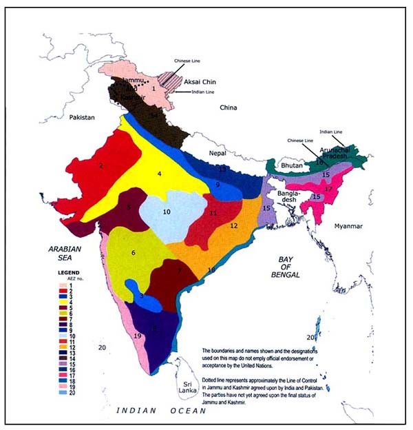
AEZ No. |
Agro-ecological region |
Geographical area (million ha) |
Gross cropped area (million ha) |
Physiography |
Precipitation (mm) |
PET (mm) |
Length of growing period (days) |
Major crops |
|
1. |
Cold arid ecoregion with shallow skeletal soils |
15.2
(4.7%) |
0.07 |
Western Himalayas |
< 150 |
<800 |
< 90 |
Vegetables, millets, wheat, fodder, barley, pulses |
|
2. |
Hot arid ecoregion with desert and saline soils |
31.9
(9.7%) |
20.85 |
Western Plain & Kachchha Peninsula |
< 300 |
1500–2000 |
< 90 |
Millets, fodder, pulses |
|
3. |
Hot arid ecoregion with red and black soils |
4.9
(1.9%) |
4.18 |
Deccan Plateau |
400–500 |
1800–1900 |
< 90 |
Sorghum, safflower, cotton, groundnut, sunflower, sugar cane |
|
4. |
Hot semi-arid ecoregion with alluvium-derived soils |
32.2
(9.8%) |
30.05 |
Northern Plain & Central Highlands including parts of Gujarat Plains |
500–800 |
1400–1900 |
90–150 |
Millets, wheat, pulses, maize; irrigated cotton & sugar cane |
|
5. |
Hot semi-arid ecoregion with medium and deep black soils |
17.6
(5.4%) |
11.04 |
Central (Malwa) Highlands,Gujarat Plains & Kathiawar Peninsula |
500–1000 |
1600–2000 |
90–150 |
Millets, wheat, pulses |
|
6. |
Hot semi-arid ecoregion with shallow and medium (dominant) black soils |
31.0
(9.5%) |
25.02 |
Deccan Plateau |
600–1000 |
1600–1800 |
90–150 |
Millets, cotton, pulses, sugar cane under irrigation |
|
7. |
Hot semi-arid ecoregion with red and black soils |
16.5
(5.2%) |
6.19 |
Deccan (Telangana) Plateau & Eastern Ghats |
600–1000 |
1600–1700 |
90–150 |
Millets, oilseeds, rice, cotton & sugar cane under irrigation |
|
8. |
Hot semi-arid ecoregion with red loamy soils |
19.1
(5.8%) |
6.96 |
Eastern Ghats (Tamil Nadu uplands) & Deccan Plateau (Karnataka) |
600–1000 |
1300–1600 |
90–150 |
Millets, pulses, oilseeds (groundnut), sugar cane & rice under irrigation |
|
9. |
Hot subhumid (dry) ecoregion with alluvium-derived soils |
12.1
(3.7%) |
11.62 |
Northern Plain |
1000–1200 |
1400–1800 |
150–180 |
Rice, wheat, pigeon pea, sugar cane, mustard, maize |
|
10. |
Hot subhumid ecoregion with red and black soils |
22.3
(5.8%) |
14.55 |
Central Highlands (Malwa & Bundelkhand) |
1000–1500 |
1300–1500 |
150–180 |
Rice, wheat, sorghum, soybean, gram, pigeon pea |
|
11. |
Hot subhumid ecoregion with red and yellow soils |
11.1
(4.3%) |
6.47 |
Eastern Plateau (Chhattisgarh Region) |
1200–1600 |
1400–1500 |
150–180 |
Rice, millets, wheat, pigeon pea, green gram, black gram |
|
12. |
Hot subhumid ecoregion with red and lateritic soils |
26.8
(8.2%) |
12.09 |
Eastern (Chhota Nagpur) Plateau and Eastern Ghats |
1000–1600 |
1400–1700 |
150–180 |
Rice, pulses, millets |
|
13. |
Hot subhumid (moist) ecoregion with alluvium-derived soils |
11.1
(3.4%) |
10.95 |
Eastern Plains |
1400–1600 |
1300–1500 |
180–210 |
Rice, wheat, sugar cane |
|
14. |
Warm subhumid to humid with inclusion of perhumid ecoregion with brown
forest and podzolic soils |
18.2
(5.6%) |
3.20 |
Western Himalayas |
1600–2000 |
800–1300 |
180–210 |
Wheat, millets, maize, rice |
|
15. |
Hot subhumid (moist) to humid (inclusion of perhumid) ecoregions with
alluvial-derived soils |
12.1
3.7%) |
8.99 |
Bengal Basin and Assam Plain |
1400–2000 |
1000–1400 |
> 210 |
Rice, jute, plantation crops |
|
16. |
Warm perhumid ecoregion with brown and red hill soils |
9.6
(2.9%) |
1.37 |
Eastern Himalayas |
2000–4000 |
<1000 |
> 210 |
Rice, millets, potato, maize, sesame, Jhum*
cultivation is common |
|
17. |
Warm perhumid ecoregion with red and lateritic soils |
10.6
(3.3%) |
1.56 |
North-Eastern Hills |
1600–2600 |
1000–1100 |
> 210 |
Rice, millets, potato, plantation crops, Jhum*
cultivation is common |
|
18. |
Hot subhumid to semi-arid ecoregion with coastal alluvium-derived soils |
8.5
(2.6%) |
6.12 |
Eastern Coastal Plains |
900–1600 |
1200–1900 |
90>210 |
Rice, coconut, black gram, lentil, sunflower, groundnut |
|
19. |
Hot humid perhumid ecoregion with red, lateritic and alluvium-derived
soils |
11.1
(3.6%) |
5.70 |
Western Ghats and Coastal Plains |
2000–3200 |
1400–1600 |
> 210 |
Rice, tapioca, coconut, spices |
|
20. |
Hot humid / perhumid island ecoregion with red loamy and sandy soils |
0.8
(0.3%) |
0.05 |
Islands of Andaman & Nicobar and Lakshadweep |
1600–3000 |
1400–1600 |
> 210 |
Rice, coconut, areca nut, oil palm |