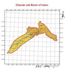
The Chenab Riveris formed by the confluence of the Chandra and Bhaga rivers at Tandi located in the upper Himalayas in the Lahul and Spiti District of Himachal Pradesh, India. In its upper reaches it is also known as the Chandrabhaga. It flows through the Jammu region of Jammu and Kashmir into the plains of the Punjab, forming the boundary between the Rechna and Jech interfluves (Doabs in Persian). The Chenab then joins the Indus at Mithankot, Pakistan. The total length of the Chenab is approximately 960 kilometres. The waters of the Chenab are allocated to Pakistan under the terms of the Indus Waters Treaty.
This river has been in the news of late due to the steps taken by the Indian government to build a number of hydropower dams along its length (in India) most notably the Baglihar hydel power project(expected time of completion 2008). This is a result of the Indus Basin Project. These planned projects on Chenab have been hotly contested by Pakistan which says that India is breaking the terms and clauses of the Indus water treaty by storing and channelling the waters of this river, a claim totally rejected by the Indian government.