The Satluj River rises as Langchen Khabab in the lakes of Mansarover and Rakastal in the Tibetan Plateau from the southern slopes of Mount Kailash at an elevation of about 4,570 m above mean sea level (msl) and forms one of the main tributaries of Indus River. It travels about 322 km in the Tibetan province of Nari‑Khorsam forming a plateau by successive deposits of boulders, gravel, clay and mud. Satluj enters into the Indian territory near Khab, a narrow cut into massive rock structure. The flow of Satluj, arising mainly from snow and glaciers, has cut a valley about 914 m deep through these deposits. Hereafter, the river flows through Himachal Pradesh and Punjab states of India. After flowing in north‑westerly direction, it changes direction towards south‑west and covers another 322 km up to Bhakra gorge, where a 225 m high straight gravity dam (Bhakra/Govind Sagar) has been constructed. The lower catchment largely drains directly into the reservoir and the higher slopes drain through tributaries. The important tributaries of the Satluj River are the Soel khad, Alseed khad, Ali khad, Gamrola khad, Ghambhar khad, Seer khad, Sukhar khad, Sarhali khad, and Lunkar khad.
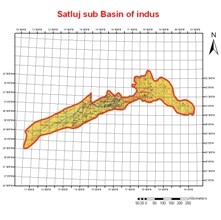
The total geographical area of Satluj River up to Bhakra dam is about 56,980 km2, of which about 37,153 km2 lies in Tibet. The remaining about 19,827 km2 area lies in the Indian territory. Indian part of the Satluj basin is elongated in shape. The shape and location of this basin is such that a major part of the basin area lies in the greater Himalayas where heavy snowfall is experienced during winters. The catchment area lies between longitudes 76o 22' E to 78o 42' E and latitudes 31o 13' N to 32o 23' N.
A major portion of the Satluj basin lies in the greater Himalayan range. The elevation of the catchment varies widely from about 500 m to 7,000 m above msl, although only a very small area exists above 6,000 m. The mean elevation of the basin is about 3,600 m. The gradient is very steep near its source and gradually reduces downstream. Owing to large differences in seasonal temperatures and great range of elevation in the catchment, the snowline is highly variable, descending to an elevation of about 2,000 m during winter.
The waters of the Sutlej are allocated to India under the Indus Waters Treaty between India and Pakistan, and are mostly diverted to irrigation canals in India. A huge, multipurpose Bhakra-Nangal Dam has been built on the Sutlej by the Indian government. There are several major hydroelectric projects on the Sutlej, e.g. the 1000MW Karcham-Wangtoo Hydroelectric project.