Characteristics of the sub-basin with available runoff data
|
Code |
K9 | |
| Length (km) | 391 | |
| Area (km2) | 23,590 | |
| Total Population 2001 (millions) | 4.65 | |
| Population Density 2001 (persons/km2) | 194 | |
| Annual Rainfall Runoff (P) | (mm) | 411 |
| (km3) | 13.4 | |
| Annual Runoff (Q) (km3) | 1.4 | |
| Runoff Coefficient (Q : P) | Observed | 0.11 |
| Predicted | 0.07 | |
| Curve | BZ | |
| Potential Evaporation Ep (mm/yr) | 1,479 | |
| Aridity Index (Ep/P) | 3.6 |
The catchment area for the sub-basins is the area between the gauging station and the nearest upstream gauging stations, and does not include the entire catchment area. (Ref : Closing of the Krishna Basin: Irrigation, Streamflow Depletion and Macroscale Hydrology, Research Report 111. IWMI)
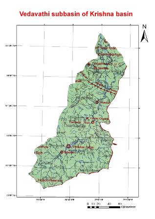
The Vedavathi rises from the Western Ghats and flows through the states of Karnataka and Andhra Pradesh. The Vedavathi is also called the Hagari in parts of Andhra Pradesh. Two rivers, the Veda and Avathi, arise in the eastern part of the Sahyadri Hill range, flow east, and join concert near Pura to form the Vedavathi.The Vani Vilasa Saagara reservoir constructed across river Vedavathi dates back a century.