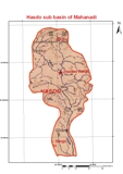
The sub-basin lies between north latitudes of 21°44' and 23°30' and east longitudes of 82°04' and 83°00'. The Hasdo River rises at an elevation of about 915 m at a place nearly 10 km north of Sonhat in the Sarguja district of Chhattisgarh. The river traverses a distance of about 333 km to join the Mahanadi on its left near village Mahuadih. The total drainage area of the river is about 9,856 km2 , which is nearly 6.96% of the Mahanadi catchment. Gej River is the principal sub tributary of the Hasdo River.