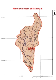
The river originates at an e1evation of about 686 m in the Sarguja district of Chhattisgarh and flows for about 241 km to its confluence with the Mahanadi on its left near Chandarpur. The Koirja nalla, Gopal nalla, Chhindai nalla and Kurket river are the principal tributaries. The river flows through 220 km from its origin to its confluence with Mahanadi near Chandrapur. The sub-basin lies between the North attitudes of 21°40' and 22°03' and east longitudes of 82°41' and 83°37'. The total catchment area of the river is about 5,200 km2.