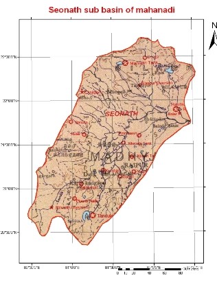
The Seonath River
is the longest tributary of Mahanadi basin. It
rises in an undulating region with numerous small groups of hills at an
elevation of about 533 m near Kotgal and flows
for about 383 km to join the Mahanadi on its
left near Kharghand. The main sub tributaries of
the Seonath are the
Kharhara, the Tandula and the
Kharun on the right bank and the
Surhi, the Hanp, the
Agar and the Arpa on the left bank. The total
drainage area of the Seonath River is about
30,761 km2 which is nearly 22% of the total drainage area of the
Mahanadi basin.
The Basin is
located between latitude 200 16' N to 220 41' N and
Longitude 800 25' E to 82035' E. The Basin area of
river up to confluence with the Mahanadi River is 30,860 Sq Km.
The mean annual rainfall in the basin varies from 1005 mm to 1255 mm.