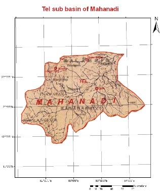
The Tel River originates in plain and open country in the Koraput district of Orissa, about 32 km to the west of Jorigam. Its principal tributaries are Udanti, Indra, Lant, Sutkel, Hatti, Ret, Uttei, Raul and Khadago. The Tel sub-basin is roughly rectangular in shape having maximum length of 230 km in the east-west direction and 182 km in the north-south direction and lies between the north latitudes of 19° 15’ and 20°55’ and east longitudes of 82° 03’ and 84°17’. The river traverses a total length of 296 km to join the Mahanadi River on the right bank, 1.6 km below Sonepur. The total drainage area of the Tel River is about 22,818 km2.