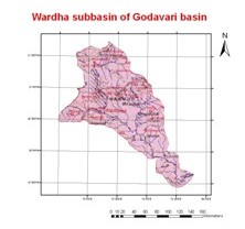
Wardha
is one of the right bank tributaries of Pranhita
River. The Wardha sub basin lies between
latitude 19°18’N
and 21°58’N
and longitudes 77°20’E
and 79°45’E.
Wardha originates at an altitude of
777 m in the Betul district of Madhya Pradesh
and enters Maharashtra about 32 km from its
source. After traversing a distance of 528 km, it joins the
Wainganga at an elevation of 146 m. The major
left bank tributaries of the Wardha are the
Kar, the Wena, The
Jam and the Erai and the right bank tributaries
are The Madu, the Bembla
and the Penganga. The drainage area of the
Wardha River is 24,087 km2 and
throughout its course, the river flows through dense forests. The average
annual rainfall for the entire sub-basin is 1,000 mm approximately.
|