Brief Description of the Basin
- One of the mightiest and the longest rivers
in the world
- Originates from
- Total length of the river is 3,199 km
-
Bisects the physical
- From its origin to the Guddu Barrage in
- The Karakoram and the Haramosh ranges bound the basin on the north, the
- Catchment area : 1,165,500 km2
-
Country under the river
- Drainage area
lying in
- Area lying in
- Drainage
area lying in
-
The river travels about 2,880 km up to its outfall into the
- Length of the river in
-
In
- Longitudes
72º 35' E to 79º 50' E and latitudes 28º 52' N to 37º 20' N.
-
The culturable area of the basin is 9.6 Mha, (about 4.9% of the total
culturable area of the country).
- mean annual
flow of the
- Contribution
of snow and glacier melt to annual runoff is about 60%
Drainage area of the basin (in Km2)
Statewise Drainage Area (in Km2)
State
Drainage Area (km2)
193,762
Himachal Pradesh
51,358
50,306
Rajasthan
15,814
Haryana
9,939
110
Total Drainage Area of
321,289
Topography
Upper
part of the basin lying in
Soil
The
principal soil types found in the basin are submontane,
brown hill, and alluvial soils.
Climate
|
S. N. |
Location |
Temperature (°C) |
Rainfall (mm) |
|
|
Maximum |
Minimum |
|||
|
1. |
|
18.7 - 32.7 |
7.0 - 26.2 |
1,300 |
|
2. |
Kathua |
18.5 - 39.4 |
8.0 - 26.0 |
1,450 |
|
3. |
Udhampur |
18.0 - 38.0 |
6.5 - 25.4 |
1,070 |
|
4. |
Rajouri |
16.5 - 36.0 |
5.3 - 23.0 |
1,065 |
|
5. |
Doda |
16.5 - 37.5 |
6.0 - 23.2 |
460 |
|
6. |
Poonch |
15.3 - 32.0 |
4.3 - 21.4 |
951 |
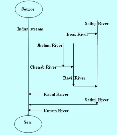
Tributaries
Jhelum
River
Chenab
River ,
Beas
River ,
Ravi
River
and
Sutlej
River
Hydropower Potential
The hydroelectric potential of the Indus basin has been assessed 33832 MW. Out of the identified schemes in the basin, schemes with a total installed capacity of 12254 MW are in operation as on 31.7.2014 and schemes with an installed capacity of about 4809 MW are in various stages of construction. (Source: www.cea.nic.in ). The status of the schemes as on 2010 is given below:
S.
No.
Name
River/Khad
MW
Status
1.
Allian – Dhungan
Allaain Nallah
192
Under Construction
2.
Malana
Malana Khad
86
Under Operation
3.
Parbati Stage – I
Parbati Khad
750
Under Construction
4.
Parbati Stage – II
Parbati Khad
800
Under Construction
5.
Parbati Stage – III
Parbati Khad
501
Under Construction
6.
Larji
126
Under Construction
7.
990
Under Operation
8.
Uhl Stage – I (Shanan)
Uhl Khad
110
Under Operation
9.
Bassi
Uhl Khad
60
Under Operation
10.
Uhl Stage – III
Uhl Khad
100
Under Construction
11.
Neogal
Uhl Khad
15
Under Construction
12.
Binwa
Binwa Khad
6
Under Operation
13.
Baner
Baner Khad
12
Under Operation
14.
Khauli
Khauli Khad
12
Under Construction
15.
Gaj
Gaj Khad
10.5
Under Operation
16.
Pong Dam
360
Under Operation
17.
Patikari
Bakhli Khad
16
Under Construction
18.
Sainj
Sainj Nallah
100
Under Investigation
19.
Gada Gosain
Tirthan Nallah
25
Under Investigation
20.
Baragaon
Baragaon Nallah
10.5
Under Construction
21.
Dhaulasidh
80.0
Under Construction
22.
Lambadug
15.0
Under Construction
23.
Trithan
18.0
Under Investigation
Total
4,495
Hydropower Potential in
S. N.
Name
River
Capacity (MW
Status
1.
Rongtong
Rongtong Khad
2.5
Under
Operation
2.
Kealing Lara
Spiti
40
Under
Investigation
3.
Lara Project
Spiti
60
Under
Investigation
4.
Mane Nadang
Spiti
76
Under
Investigation
5.
Nadang
Spiti
80
Under
Investigation
6.
Lari Sumate
Spiti
104
Under
Investigation
7.
Sumte Kothans
Spiti
130
Under
Investigation
8.
Chango Yangthang
Spiti
140
Under
Investigation
9.
Yangthang Khab
Spiti
400
Under Investigation
10.
Khab Pooh
Satluj
340
Under
Investigation
11.
Pool Spillo
Satluj
300
Under
Investigation
12.
Jhangi Thopan
Satluj
300
Under
Investigation
13.
Thopan Powari
Satluj
400
Under
Investigation
14.
Shongtong Karcham
Satluj
225
Under
Investigation
15.
Baspa Stage - I
Baspa
210
Under
Investigation
16.
Rukti
Rukti Khad
1.5
Under
Operation
17.
Baspa Stage - II
Baspa
300
Under
Construction
18.
Karcham Wangtoo
Satluj
1,000
Under
Construction
19.
Bhaba Aug. P/H
Shango Khad
3
Under
Construction
20.
SVP Bhaba
Bhaba Khad
120
Under
Operation
21.
Nathpa Jhakri
Satluj
1,500
Under
Operation
22.
Ghanvi
Ghanvi Khad
22.5
Under
Operation
23.
Satluj
403
DPR Ready
24.
Nogli Stage - I
Nogli
2.5
Under
Operation
25.
Chaba
Nauti Khad
1.75
Under
Operation
26.
Kol Dam
Satluj
800
Under
Construction
27.
Bhakra Dam
Satluj
1,200
Under
Operation
28.
Keshang
Keshang Khad
160
Under
Construction
29.
Sorang
Sorang
100
Under
Investigation
30.
Tidong
Tidong Khud
100
Under
Investigation
31.
Karang
Karang Khud
16
Under
Investigation
32.
Ropa
Ropa Khud
80
Under
Investigation
33.
Ghanvi-II
Satluj
7
Under
Construction
34.
Barhal
Satluj
9
Under
Investigation
Total
8,633.75
Surface Water
Potential of the
An average annual surface water potential
of 73.3 km3 has been assessed in this basin. Out of this, 46.0 km3
is utilizable water. Culturable area of the basin
is about 9.6 M ha, which is 4.9% of the total culturable
area of the country. The seasonal flow in each
Bhakra Nangal System, Bhakra Dam, Nangal Barrage, Bhakra Canal Systems, Beas-Satluj
Link, Pandoh Dam, Pong Dam,
Indira Gandhi Nahar Project
(IGNP), Nathpa Jhakri Hydroelectric Project,
Anandpur Sahib,
Baira Siul Project,
Baglihar
Hydro-Electric Project, Chamera Project, Dulhasti Project, Kishanganga Project,Kol Dam,
Problems
Flash Floods
Water quality of the tributaries of the basin in Punjab
S. No.
Parameter
Satluj
Ghaggar
1
Temperature 0C
16
16
16
14
2
PH
7.7
7.6
7.8
7.8
3
Conductivity (mmho)
378
424
342
202
4
Nitrogen (NO2 + NO3)
1.0
2.34
1.4
.04
5
DO (mg/l)
7.7
5.8
7.8
9.0
6
BOD (mg/l)
1.8
28.0
4.2
0.4
7
COD (mg/l)
6.4
57.6
14.4
1.6
8
Cl- (mg/l)
20
54.0
23.0
10
9
So4
14
30
16
8.0
10
Na
4.2
21.2
14.6
1.8
11
Fecal Coliform
170
500
500
0.0
12
Turbidity (NTU)
22
62
24
7.0
13
Total Coliform
500
9,000
5,000
7.0
14
TDS
340
396
302
194