Brief Description
-
The
-
It lies between east longitudes 80° 30' to 86° 50' and north latitudes 19° 21' to 23° 35'.
-
It is bounded on the north by the
-
The upper basin is a saucer shaped and mostly lies in Chhattisgarh state.
-
The basin is circular in shape with a diameter of about 400 km and an exit passage of about 160 km length and 60 km breadth
-
Physiographically, the basin can be divided into four regions, namely, the northern plateau, the
-
The basin has a culturable area of about 79,900 km2 which is about 57% of the basin area and four percent of the total culturable area of the country.
Mahanadi River
-
The Mahanadi is one of the major east flowing peninsular rivers draining into Bay of Bengal.
-
The Mahanadi river ranks second to the Godavari river among the peninsular rivers in respect of water potential.
-
The Mahanadi rises in a pool, 6 km from Pharsiya village near Nagri Town in Raipur district of Chhattisgarh state at an elevation of 457 m.
-
The total length of the river form origin to its outfall into Bay of Bengal is 851 km of which 357 km lies in Chhattisgarh and 494 km in Orissa.
-
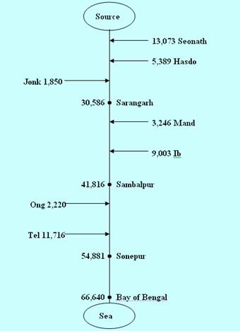
The principal tributaries of the Mahanadi river are; Sheonath, Jonk, Hasdeo, Mand, Ib, Ong and Tel.
River Network
The numbers represent average annual flow in cumec.
Drainage area (in Km2)
Statewise Drainage Area (Km2)
Name of State
Drainage area
Chhattisgarh
75,136
Orissa
65,580
635
238
Total Drainage Area
141,589
Drainage Density
The total length of stream within a catchment divided by the drainage area defines the drainage density of the catchment. Drainage density can also be expressed as length of channels per unit area. The drainage density of the Mahanadi basin upto Manibhadra dam site works out to be 0.022, which is within the range of low drainage density value. It depicts that the basin has a high resistance with permeable soil under dense vegetative cover and low relief.
Topography
The upper reaches of the sub-basin lies in a very undulating plateau with hill locks eroded moulds. The southern part of the plateau is open but to the east and west there are a number of hill ranges, which have steep. slopes resulting in water draining directly into the Mahanadi river. The basin upto Manibhadra is continuously sloping towards the main valley and therefore no drainage congestion is anticipated.
Physiography
The basin upto Manibhadra can be divided into five groups physiographically viz.
-
Hill top and slope
-
Upland,
-
Medium land
-
Low land and
-
River banks
Geology
The catchment upto Manibhadra mostly comprises of archean terrain and consolidated gneiss rock formation greatly influenced by geomorphic features. The hills have igneous and metamorphic rocks under Gangpur series, the important types being quartzite, phyllite, quartz schist, Mica schist and granite. The sub-basin comprises of alluvial formation of recent origin of varying thickness.
Rainfall
The basin receives about 90% of its rainfall during the monsoon season. Generally, the southwest monsoon sets by the middle of June over the entire basin and remains active till the end of September. The spatial variation in rainfall is moderate in the basin. The formation of depressions in the Bay of Bengal cause cyclones, which bring about wide spread heavy rains resulting in floods and destructions. There are 149 IMD raingauge stations in and around the basin.
Temperature
The coldest and hottest months in the basin are December and May respectively. The highest monthly mean maximum temperature was recorded as 42.7°C at Titlagarh in the month of May while the lowest monthly mean minimum temperature of 8.4°C was recorded at Ambikapur. The highest single point temperature of 48.6°C was recorded at Titlagarh on 10.05.1973. The lowest single point temperature of 0°C was recorded at Raigarh on 25.12.1955.
Relative Humidity
It is observed that higher mean monthly relative humidity values are re, during the monsoon season in the basin. The highest mean monthly relative humidity value at 08.00 hrs was recorded as 88% in the month of August at Ambikapur. The lowest mean monthly value at 17.00 hrs was recorded as 18% in the month of April at Raigarh:
Wind Speed
It is observed that higher values of wind speed are recorded during the months of May, June and July. The highest monthly wind speed of 15.5 km/hour was recorded in the month of June at Raigarh while the lowest monthly wind speed of 2.3 km per hour was recorded in the month of December at Ranchi.
Sunshine
It is observed that cloud cover is higher during monsoon season and less during the months of December, January and February. The highest mean monthly cloud amount at 08.00 hrs was recorded as 7 Oktas in the month of July at Raipur. The highest mean monthly cloud amount at 17.00 hrs was recorded as 7.1 Oktas in June, July at Raipur and Ranchi.
Soil and Land use
The
main soil types found in the basin are red and yellow soils. Mixed red and black soils occur in parts of
the Bolangir, Sambalpur,
and Sundargarh districts of Orissa. Laterite soil is
found in the lower parts of Orissa. The deltaic
soil is found in the coastal plains of the
Except in the Chhatisgarh and coastal plains, the basin has an
extensive area under forests.
The information regarding the physical, chemical, morphological characteristics and classification of the soils of an area is necessary for suggesting appropriate cropping pattern, intensity of irrigation and water requirement etc. for sustainable development of irrigation leading to more produce and prosperity .The soils in the basin can be grouped broadly into six types based on the reconnaissance soil survey done by the soil survey department of Chhattisgarh state in the command area of the Hasdeo Bango Project, pre- irrigation soil survey done by Orissa Soil Conservation Department in the ayacut of Ib project and Water Resources Atlas. Based on the information provided by these surveys and the soil maps prepared by the National Thematic & Mapping Organisation (NATMO), Govt. of India, Ministry of Science & Technology, Kolkata. The districtwise description of various types of soils and their characteristics in the basin are furnished below.
Red Soils
These soils may either be red gravelly, red sandy, red loamy, red and yellow or red earth according to the gravel, sand, or presence of fine particles and clay content. These are found in large tracts of basin. These are found in Surguja, Bilaspur, Raigarh, Bastar, parts of Rajnandgaon districts of Chhattisgarh and availability districts of Maharashtra. These soils are medium to fine in texture and porous. These soils have low water holding capacity. The red loamy soils are moderately acidic in nature and deficient in Nitrogen, Calcium, Potassium and low in organic matter in content. However, with green manuring and application of fertilizers, these soils can be profitably managed for cultivation of fruits, vegetables and other cash crops. The main crop is paddy. The colour of the soil is red due to presence of Iron oxide. The clay fraction of the red soil is much in Keolinite type of clay mineral with varying proportion of Iolite.
Laterite Soils
These soils are found in small patches in Raigarh, Durg, Raipur districts of Chhattisgarh and Bargarh district of Orissa. These soils derive their name from the presence of laterite mass either at surface or at some depth beneath the ground level.These have soils have honeycombed structure. These soils are acidic in nature.
Black Soils
These soils are found in Durg, Raipur and Rajnandgaon districts of Chhattisgarh, Sahadol of Madhya Pradesh, Nuapada, Kandhamal, Boudh, Sonepur, Bolangir, Bargarh and Sambalpur districts of Orissa. These soils are moderately deep to very deep in extent and dark grayish brown to black in colour. Accordingly, it is termed as deep, medium, shallow black. These soils possess clayey texture. These soils are calcareous and are alkaline in nature. They are highly retentive and moderately well drained. These Soils are rich in Montemorilonitic group of minerals & deficient in Nitrogen, Phosphoric acid and organic matter but sufficient in Potassium, Magnesium and Lime. These soils are best suited for cultivation of paddy and cotton.
Alluvial Soils
These soils are found in small patches in the basin. The percentage of area under this type of soil is low as compared to the other types of soils. The colour of the soil varies from pale brown at the surface to dark brown underneath. The surface horizons are loamy sand in texture whereas the lower horizons are finer in texture. These soils are very deep,well drained, slightly acidic to neutral in reaction and are low to medium in organic matter content and low in nitrogen content.
Red and Yellow Soils
These soils are found along the banks of the Mahanadi river upto the Hirakud dam and along the banks of Ib and Mand Rivers. These soils are reddish brown to yellowish red in colour. They have mainly developed from Archean formation consisting of gneisses and granites of gondwana systems. They are medium to fine in texture. They have poor water retentive capacity. They are acidic to neutral in reaction.
Mixed Red and Black Soils
These soils are found in the banks of Mahanadi, its tributary Ong and its sub- tributary Jira, Jhaun etc. The districts coming under this type of soil are Baragarh, Sonepur, Bolangir. These soils contain Iron & Manganese content in large proportion hence these are fine to medium fine texture, porous to semi porous in nature. These are suitable for paddy cultivation.
Land Irrigability Classification
The pre-irrigation survey conducted in the command area of the Chhirpani and Hap irrigation projects in the Sheonath sub-basin have revealed that 99% of the project area is suitable for irrigation. The pre-irrigation survey conducted by the Orissa Soil Conservation Department in the Ib Irrigation Project area indicated that 95% of the project area is suitable for irrigation.
Land use
Culturable area of the basin during the year 1998-2003
|
Year |
Culturable area (ha.) |
|
1998-1999 |
5818476 |
|
1999-2000 |
5709631 |
|
2000-2001 |
5818671 |
|
2001-2002 |
5896556 |
|
2002-2003 |
5872245 |
Land Use Particulars of the Basin in the Year 2001-2002
|
Sl. No. |
Land type |
Area in ha |
Percentage |
|
01 |
Forest |
3362125 |
26.72 |
|
02 |
Barren and uncultarable land |
1938349 |
15.41 |
|
03 |
Land under non-agricultural use |
774862 |
6.16 |
|
04 |
Permanent pasture and other grazing lands |
610108 |
4.85 |
|
Sub-total (1+2+3+4) |
6685444 |
53.14 |
|
|
05 |
Cultural waste land |
262896 |
2.09 |
|
06 |
Land under Misc. crops &trees |
21775 |
0.17 |
|
07 |
Current fallows |
474611 |
3.77 |
|
08 |
Other fallows |
302748 |
2.41 |
|
09 |
Net area sown |
4834526 |
38.42 |
|
Culturable Area (5+6+7+8+9) |
5896556 |
46.86 |
|
|
Geographical area |
1,25,82,000 |
100.00 |
|
Average Cropping Pattern for Mahanadi Basin upto Manibhadra Dam Site
|
Name of the Crops |
Area (ha) |
Percentage (%) |
|
Paddy |
2299979 |
83.50 |
|
Wheat |
31044 |
1.10 |
|
Maize |
14213 |
0.50 |
|
Ragi |
7823 |
0.30 |
|
Green-gram |
38 |
0.00 |
|
Black-gram |
32 |
0.00 |
|
Horse-gram |
36 |
0.00 |
|
Til |
19737 |
0.70 |
|
Mung |
36525 |
1.30 |
|
Groundnut |
25640 |
1.00 |
|
Mustard |
5768 |
0.20 |
|
Potato |
5648 |
0.20 |
|
Sessamum |
74 |
0.00 |
|
Biri |
37716 |
1.40 |
|
Jute |
81 |
0.00 |
|
Sugarcane |
6500 |
0.20 |
|
Jowar |
244 |
0.00 |
|
Bajra |
7 |
0.00 |
|
Kodan- Kutki |
48342 |
1.80 |
|
Tur |
134 |
0.00 |
|
Gram |
66 |
0.00 |
|
Barley |
11 |
0.00 |
|
Linseed |
76 |
0.00 |
|
Rape & Mustard |
155 |
0.00 |
|
Soya been |
74 |
0.00 |
|
Sunflower |
1026 |
0.00 |
|
Vegetables |
26 |
0.00 |
|
Pulses |
6205 |
0.20 |
|
Other Pulses |
60126 |
2.20 |
|
Other Oilseeds |
9352 |
0.30 |
|
Other Cereals |
45749 |
170 |
|
Other Food Crops |
92804 |
3.40 |
|
Total |
2755251 |
100.00 |
Climate
To the north, in the region of the
Water Potential of the
Basin
Surface Water potential
66.88 km3
Ground Water potential
16.46 km3
Water Utilization
Surface Water Utilization
Drinking Purposes
Irrigation Purposes
Ground Water Utilization
Drinking Purposes
Irrigation Purposes
Tributaries with
Drainage Area in sq. km.
Name of the Tributary
Drainage area (Km2)
Seonath
30,761
Jonk
3,484
Hasdeo
9,856
Mand
5,200
Ib
12,447
21,652
Ong
5,128
Tel
22,818
Middle
12,654
17,589
Total
141,589
Hirakud Dam, Ravishankar Sagar, Dudhawa Reservoir, Sondur Reservoir, Hasdeo Bango
and Tandula
Water Quality of the Basin
Based on investigations, CPCB has determined water
quality classes of various reaches of
Population
The population of Mahanadi basin upto Manibhadra as per the 2011 census was computed on proportionate area basis from the district figures works out to 230.95 lakh of which the rural population was 176.90 lakh and urban population was 54.05 lakh. The state wise population falling in basin is computed as 128. 78lakh in Chhatisgarh, 0.08 lakh in Madhya Pradesh, 0.10 lakh Maharashtra, 0.14 lakh in Jharkhand and 101.85 lakh in Orissa.
Forest
Out of total geographical area of 12582000 ha of the basin based on land use year 2001-2002 forests occupy nearly 3362125 ha i.e. 26.72% of the total geographical area. The area covered by the forests is nearly 4165 ha (38.92%) in Madhya Pradesh, 2765314 ha (36.76%) in Chhatisgarh, 1128 ha (8.95%) in Jharkhand, 10039 ha (42.18%) in Maharashtra and 581479 ha (11.60%) in Orissa state. There are three types of forest in the basin i. e. mainly reserve forest, protected and unclassified. The tribal people of the basin area mainly depend upon the forest products and forest related industries.
The population of the basin is dependent on the forest produce for their domestic fuel needs and on Kendu, honey, wax, tamarind, mahua, resin and sal seeds for commercial purposes. The northwestern and southern parts of the Sheonath sub-basin and northern parts of the Hasdeo sub-basin are covered with forested hills. In the Sheonath sub-basin as well as in Hasdeo sub-basin, dry Sal forests are seen mostly on flat grounds below the ghats while moist Sal forests are seen in higher elevations. Deciduous types forests are seen in the Jonk, Ib, Tel and Middle Mahanadi sub-basins and in some portions of Mand sub-basin.
The commonly available species in the forests in the basin are Teak, Tamarind, Mahul, Mango, Tendu leaf, Char, Jamun, Kusum, Bija Peasal, Simul, Saaj, Haldu, Palas, Asan and Bamboo .
The animal species found in the basin are lion, deer, rabbit, bear, fox, wild buffalo and reptiles. Different state in basin area has planned to develop forestry in the basin a major thrust towards ecological balance energy conservation and economic stability of rural population. There are many sanctuaries eg. Ushafotti, Khatasuno, Sotfosi gorge, compare, falling in basin area.
Agriculture and Animal Husbandry
The net sown area in the year 2001-02 in the basin is 4834526 ha which works out to be 81.99% of the culturable area of the basin. The principal crop grown in the basin is paddy while other important crops grown are Kodon-Kutki, pulses, wheat, maize, gram and linseed.
The net sown area in the basin 4834526 ha is 38.42% of the geographical area. The values of net sown area in Madhya Pradesh, Chhatisgarh, Jharkhand, Maharashtra and Orissa in ha area 3486 (32.58%),3228110 (42.91%),2248 (17.84%),1712 (7.19%) and 1598970 (31.90%) respectively. The main occupation of the people in the basin is agriculture.
Various agricultural implements
used in the area are
(1) Manually operated: seed cum fertilizer drill, chiff
cutter, wheel hoe, sprayer duster etc.
(2) Animal operated: wooden and steel
ploughs, disc harrows, seed cum fertilizer drill, cultivator (triphate)
leveler, wet land peddler, olpad trushers, carts, Persian wheel sugarcane
crushers etc. and
(3) Power driven: sprayer, duster, pumps, tillers, tractors,
mould board plough, disc harrow, potato digger, trailer, tresher, sugar cane
crusher etc.
Irrigation
The gross irrigated area through the canals, wells, tanks and other sources in the Mahanadi basin upto Manibhadra during the year 2003-04 is 1692046 ha, which works out to be 28.70% of the culturable area. The gross irrigated area through canals, wells, tanks and other sources in Chhattisgarh, Madhya Pradesh, Jharkhand, Maharashtra and Orissa are 1236787 ha, 247 ha, 54 ha, 636 ha and 454322 ha respectively.
Power
There are two existing thermal power stations at Korba viz. the Korba thermal power stations (MPEB) (540 MW) and the Korba super thermal power station (600 MW). The Barry power station (MPEB) is under construction. One super thermal power project is proposed in the Ib sub-basin near Sundergarh with an installed capacity of 1000 MW and one super thermal power station is also proposed near Kharsia town.
There are two existing hydroelectric powerhouses; one is at Burla with an installed capacity of 198 MW and the other one is at Chipilima with an installed capacity of 72 MW , which utilizes the water from Hirakud dam for power generation.
There are proposals to take up various power projects in the basin with an installed capacity of 4306 MW. The Hasdeo Bango multipurpose project will provide 120 MW of hydel power. One hydel power project is proposed in Raipur district. One hydel project in the Ib sub-basin in Sambalpur district of 1450 MW capacity is proposed. A list of proposed power projects in the basin as per the Govt. of Orissa state is given below.
|
Sl.No |
Name of the project |
Capacity |
|
1. |
Sasan Canal Hydro Electric Scheme |
1450 KW |
|
2. |
Addnl. Generation of power from Hirakud dam |
135 KW |
|
3. |
Addnl. Generation of power from Chipilima |
135 MW |
|
4. |
Baragarh H.R. small Hydel Scheme |
9 MW |
|
5. |
Attabira Hydro Electric Schme |
350 MW |
|
6. |
Godabhanga Hydro Electric Scheme |
200 KW |
|
7. |
Andhribhangi Hydro Electric project |
325 KW |
|
8. |
Titlagarh Hydro Electric scheme |
200 KW |
|
9. |
Upper Jonk Rt. Canal |
300 KW |
|
10. |
Raidras H.F. scheme |
130 KW |
|
11. |
Lower Indra H.F. project |
3 MW |
|
12. |
Pipal pala H.F. project |
120 KW |
|
13. |
Ret. H.F. scheme |
600 KW |
|
14. |
Phuljharan H.F. scheme |
300 KW |
|
15. |
Behera H.F. scheme ' |
120 KW |
|
16. |
Dokrichanchara Hydro Electric Project |
1000 KW |
|
17. |
Deogaon |
365 MW |
|
18 |
Kapasira |
397 MW |
|
19. |
Godhaneswar |
522 MW |
|
20. |
U.I. Rt. Main Canal at R.D.10.252 Km |
2000 KW |
|
21. |
U.I. Rt. Main canal at R.D. 24.142 Km |
1500 KW |
|
22. |
Tel |
20 MW |
|
23. |
Lower Suktel M.H. scheme |
300 KW |
|
24. |
Raul- Uttei M.I. Scheme |
195 KW |
|
25. |
Uttei M.H. scheme |
120 KW |
|
26. |
Dhauragotha & Kutu1isingha Hydro Electric Project |
270 MW |
|
27. |
Manjora Hydro Electric Project |
200 KW |
|
28. |
Bagh small 11 M.H.F. scheme |
6 MW |
|
29. |
Salki H.F. project |
27 MW |
|
30. |
Burtang H.F. Project |
7 MW |
|
31. |
Manibhadra H.F. Project |
960 MW |
|
32. |
Sapua- Badjore Canal |
200 KW |
|
33. |
Ranpur Mini H.F. Project. |
300 KW |
|
34. |
Birupa Barraja H.F. scheme. |
3000 KW |
|
35. |
Birbati mini H.F. scheme. |
650 KW |
|
36. |
Baraboria mini H.F. scheme. |
650 KW |
|
37. |
Kendupatna mini H.F. |
500 KW |
Water Needs for Domestic Purposes (Population in 1000)
|
S1. no |
Nature of Population |
Human Population |
Live Stock |
Water needs |
Water requirement. (Mm3) |
|||||
|
|
State |
Urban |
Rural |
|
Urban |
Rural |
Live Stock |
Surface water |
Ground water |
Total |
|
1 |
Orissa |
9155 |
4716 |
20592 |
451 |
121 |
376 |
511 |
436 |
947 |
|
2 |
Jharkhand |
13 |
7 |
115 |
1 |
0 |
2 |
1 |
2 |
3 |
|
3 |
Madhya Pradesh |
7 |
4 |
17 |
0 |
0 |
0 |
0 |
0 |
0 |
|
4 |
Chhatisgarh |
11576 |
5963 |
20743 |
570 |
152 |
379 |
646 |
455 |
1101 |
|
5 |
Maharashtra |
9 |
5 |
16 |
1 |
0 |
0 |
1 |
0 |
1 |
|
|
Total |
20760 |
10695 |
41483 |
1023 |
273 |
757 |
1159 |
893 |
2052 |
|
|
Per capita Daily Needs (liter) |
135 |
70 |
50 |
|
|
|
|
|
|
The ultimate area to be brought under irrigation and the total water requirement by 2050 AD in the Mahanadi basin upto Manibhadra are given in Table below.
|
Category |
Annual Irrigation (ha) |
Water Requirement (Mm3) |
|
|
A. |
Existing projects |
|
|
|
|
Major |
11,43,721 |
9,806 |
|
Medium |
1,67,233 |
1,514 |
|
|
Minor |
2,76,520 |
1,416 |
|
|
Sub total |
15,87,474 |
12,736 |
|
|
B. |
Ongoing projects |
|
|
|
|
Major |
4,40,586 |
4,083 |
|
Medium |
70,399 |
559 |
|
|
Minor |
2,29,120 |
1,384 |
|
|
Sub total |
7,40,105 |
6,026 |
|
|
C. |
Proposed projects |
|
|
|
|
Major |
13,32,843 |
8,260 |
|
Medium |
3,17,729 |
2,051 |
|
|
Minor |
9,73,313 |
5,009 |
|
|
Lift schemes |
1,86,551 |
855 |
|
|
Evaporation losses |
|
2,238 |
|
|
Subtotal |
28,10,436 |
18,413 |
|
|
Grand total |
51,38,015 |
37,175 |
|
The ultimate irrigation in the basin is estimated to be 51,38,015 ha which is 87.00% of maximum culturable area of the basin. The ultimate irrigation requirement is estimated as 37,175 Mm3.
Hydropower needs
There are two existing hydroelectric power projects in the basin. One is located at the Hirakud dam, Burla and the other is at Chiplima on the canal carrying the tailrace water of Hirakud dam Power House. The total installed capacity of this two-power house is 270 MW. The Govt. of Orissa have proposals for installation of 3 Hydel power schemes of run-off river in nature on Mahanadi namely Deogaon, Kapasira and Godhaneswar with an installed capacity of 365 MW, 397 MW and 522 MW respectively. The evaporation loss for the existing Hirakud dam is 801 Mm3. Evaporation losses are not considered for run-off river scheme.
The total surface water requirements for various purposes (State-wise) in Mm3
|
Purpose |
Chhattisgarh |
Orissa |
Madhya Pradesh |
Maharashtra |
Jharkhand |
Total |
|
Domestic |
646 |
511 |
1 |
- |
1 |
1,159 |
|
Irrigation |
22,075 |
15,100 |
- |
- |
- |
37,175 |
|
Industrial |
1,101 |
947 |
- |
- |
3 |
2,052 |
|
Hydropower |
- |
801 |
- |
- |
- |
801 |
|
Environment & Ecological |
|
251 |
- |
- |
- |
251 |
|
Total |
23,822 |
17,610 |
2 |
- |
4 |
41,438 |
Ground Water Potential and Expected Area to be Irrigated (Unit :Mm3)
|
Sl. No. |
Particular |
Madhya Pradesh |
Maharashtra |
Jhark-hand |
Orissa |
Chhattisgarh |
Total |
|
a) |
Gross ground water potential |
10 |
16 |
5 |
4,627 |
4,270 |
8,928 |
|
b) |
Provision for domestic and industrial purpose @15% of (a) |
2 |
3 |
1 |
693 |
641 |
1,340 |
|
c) |
Ground water available for irrigation development (a) -(b) |
8 |
13 |
4 |
3,934 |
3,629 |
7,588 |
|
d) |
Exiting draft |
0 |
2 |
1 |
459 |
1,368 |
1,830 |
|
e) |
Balance ground water available for exploitation (c) -(d) |
8 |
11 |
3 |
3,475 |
2,261 |
5,758 |
|
f) |
Area that can be irrigated from balance water in lakh ha |
0.02 |
0.02 |
0.01 |
7.55 |
4.92 |
12.52 |
Mineral Wealth
The basin is comparatively rich in mineral resources. The coal deposits are available in the Ib sub basin in Sambalpur district. Coal reserves are also found in Korba, Jatraj, Tamberi, Ronkey, Manikpur and Bisrampur of the Hasdeo sub-basin and in Sundargarh district of Orissa. Manganese ore is found in the Jharsuguda district and near Patanagarh of Bolangir district of Orissa. Bauxite is found in Kalahandi, Bolangir and Sambalpur districts of Orissa and in Jashpur area of Madhya Pradesh. Gold is also found near Dharamjaygarh in the Mand sub-basin and in the Mahasamund area of the Jonk sub-basin. Gold is also available in small quantities on the banks and bed of the Ib river in the Jashpur area. Pyrite is available near Katgi. Iron ore is found near Dalli Rajara in Rajnandgaon district. Iron ore, Bauxite, Galena are found along the banks of Kurket river, a tributary of Mand, Graphite deposits are found in Nuapada, Bolangir, Kalahandi, Sambalpur districts of Orissa. Lead, Zinc, Iron Ore, Soap-stone are found in Sundargarh district. Limestone, lead, Manganese, Mica, Dolomite, Fireclay, China Clay, Copper, Quartz are also found in the basin.
Problems in the Basin
Flood problem has
been observed in the basin, particularly in delta areas.
Mythology
The
literal meaning of