Brief Description of the Basin
-
Tapi basin is situated in the northern part of the Deccan Plateau.
-
Extends over an area of 65,145 km.
-
The basin lies between east longitudes of 72º 38' to 78º 17' and north latitudes of 20º 5' to 22º 3'.
-
It is bounded on the north by the Satpura range, on the east by the Mahadeo hills, on the south by the
-
The culturable area of the basin is about 4.29 Mha.
-
The forest cover is about 25% of the area in the basin.
-
Physiographically, the area is a basaltic landscape with major physiographic units of plateau lands, escarpments, hills, piedmont plains, colluvio-alluvial plains and valley plains.
-
The entire Tapi basin can be divided in three sub-basins:
Drainage Area of the Basin
Name of State
Drainage area ( Km2)
Madhya Pradesh
9,804
51,504
3,837
Total Drainage Area of
Topography
The Tapi basin has two
well-defined physical regions, viz., the hilly regions and the plains. The hilly
regions cover the Satpura, the Satmala,
the Mahadeo, the
The basin in Madhya Pradesh is mostly
covered with
Water Potential of the Basin
Surface Water potential
14.88 Km3
Ground Water potential
8.27 Km3
Hydropower Potential
Water Utilization
Surface Water Utilization
Drinking purposes
Irrigation purposes
Ground Water Utilization
Drinking purposes
Irrigation purposes
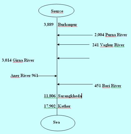
Tributaries
Vaki, Aner, Arunawati, Gomai, Nesu,
Sonkhedi Tank, Sukta, Chandora, Katepurna, Nalganga, Uma, Nirguna, Morna, Gyanganga, Mos, Paltag, Man, Thoran, Hathnur, Girna, Manyad, Bori, Suki, Abhora,
Boker Bari, Agnawati, Tondapur, Aner, Karwand,
anjhra, Malangaon, Kanholi, Burai, Arunawati, Rangawali, Nagasakya,
Haran bari, Ukai, Kakrapar, Lakhigav, Ver
Water Quality of
Water Quality Status at
Different Locations in
Location
Desired Class
2001
Tapi at Nepanagar, M.P.
A
B,
Totcoli
Tapi at Burhanpur, M.P.
A
B,
Totcoli
Tapi at Hathnur, M.P.
A
B,
Totcoli
Tapi at
D,
BOD, Totcoli
Tapi at Bhusawal U/S,
C
D,
BOD
Tapi at
D,
BOD
Tapi at Ukai,
C
NA
Tapi at Mandavi,
C
NA
Tapi at Kathore, (NH-8
Bridge),
C
NA
Problems in Water Resources
Development of
During monsoons, the
Floods were a frequent phenomenon in
Mythology
Also known by the name Tapti,
Tapi was a daughter of Sun. Ptolemy named it Nanagouna. It
is believed that Tapi rises from the sacred tank of
Multai (Mulatapi, i.e.,
the source of Tapi). The Tapi
has its name derived from tapa, ‘heat’ and according to local Brahmanas, it was created
by the Sun to protect himself from his own warmth.